Difference between revisions of "2013-01-07 48 9"
imported>Ekorren (Gallery added) |
imported>Ekorren m |
||
| Line 24: | Line 24: | ||
== Gallery == | == Gallery == | ||
<gallery> | <gallery> | ||
| − | File:2013-01-07_48_9_hashpath_1.JPG| | + | File:2013-01-07_48_9_hashpath_1.JPG|The hashpath |
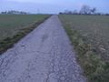
File:2013-01-07_48_9_hashpath_2.JPG| | File:2013-01-07_48_9_hashpath_2.JPG| | ||
File:2013-01-07_48_9_GPS.JPG|coordinates reached | File:2013-01-07_48_9_GPS.JPG|coordinates reached | ||
Revision as of 14:57, 3 May 2014
| Mon 7 Jan 2013 in 48,9: 48.9447156, 9.1796635 geohashing.info google osm bing/os kml crox |
Contents
Location
Freiberg am Neckar, just a simple track
Participants
Expedition
It was too easy, hardly off my "where I'm going anyway" route, so when I checked the coordinates on Friday I just thought "this won't require any planning". On monday, I totally had forgotten about the hash and it came back into my mind a little bit late... but not entirely too late to try. I could still spend 33 minutes for a stopover at a train station a few km from the hash. And so I did.
Well, there were about 9 km to go by bike within of that time (round trip), including traffic lights, traffic, a significant hill to cross twice, and documenting the visit.
And still, it worked out. However, to show just how narrow the time-planning was, let's just say... there were two trains I could take to continue after the visit: One at 17:21, one at 17:24. I missed the first but caught the second.
Gallery
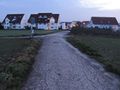
The hashpath
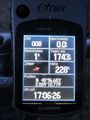
coordinates reached
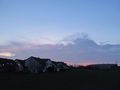
view from hash


