Difference between revisions of "2013-01-19 60 22"
From Geohashing
imported>Pehku (→Photos) |
imported>FippeBot m (Location) |
||
| (8 intermediate revisions by 2 users not shown) | |||
| Line 1: | Line 1: | ||
| − | |||
<!-- If you did not specify these parameters in the template, please substitute appropriate values for IMAGE, LAT, LON, and DATE (YYYY-MM-DD format) | <!-- If you did not specify these parameters in the template, please substitute appropriate values for IMAGE, LAT, LON, and DATE (YYYY-MM-DD format) | ||
| Line 18: | Line 17: | ||
__NOTOC__ | __NOTOC__ | ||
== Location == | == Location == | ||
| − | + | In a field in Piikkiö. | |
== Participants == | == Participants == | ||
| − | + | [[User:Pehku|Pehku]] | |
| − | |||
== Plans == | == Plans == | ||
| Line 31: | Line 29: | ||
| − | *My first geohash! | + | *My first geohash! |
| + | I walked to the point in a nice winter weather. One temperature meter on my route showed it was less than -20 degrees but at the point my phone showed it was only -10. I guess -20 was closer but it was not too cold since I had warm clothes on. | ||
| + | |||
| + | I saw a fox running in the field near the zero point but he has not been visited it though :) | ||
| + | |||
| + | -- [[User:Pehku|Pehku]] [http://www.openstreetmap.org/?lat=60.41060121&lon=22.54375454&zoom=16&layers=B000FTF @60.4106,22.5438] 08:00, 19 January 2013 (EST) | ||
| + | |||
== Tracklog == | == Tracklog == | ||
<!-- if your GPS device keeps a log, you may post a link here --> | <!-- if your GPS device keeps a log, you may post a link here --> | ||
| Line 44: | Line 48: | ||
Image:ZeroPoint 20130119.jpg | At the Zero | Image:ZeroPoint 20130119.jpg | At the Zero | ||
| + | |||
| + | Image:Route-20130119.png | Route I walked when visiting the point. | ||
</gallery> | </gallery> | ||
== Achievements == | == Achievements == | ||
{{#vardefine:ribbonwidth|800px}} | {{#vardefine:ribbonwidth|800px}} | ||
| − | + | {{Land geohash|latitude=60|longitude=22|date=2013-01-19|name=[[User:Pehku|Pehku]]}} | |
| − | + | {{Frozen Geohash|latitude=60|longitude=22|date=2013-01-19|temperature=about -10°C|name=[[User:Pehku|Pehku]]}} | |
| + | {{Tron|latitude=60|longitude=22|date=2013-01-19|name=[[User:Pehku|Pehku]]|tracklog=http://www.gpsvisualizer.com/display/1358614391-05927-88.113.34.7.html|possessive=his}} | ||
| + | {{Walk geohash|latitude=60|longitude=22|date=2013-01-19|name=[[User:Pehku|Pehku]]}} | ||
| − | |||
| − | |||
| − | |||
| − | |||
| − | |||
| − | |||
| − | |||
| − | |||
| − | |||
| − | |||
[[Category:Expeditions]] | [[Category:Expeditions]] | ||
| − | + | [[Category:Expeditions with photos]] | |
| − | [[Category:Expeditions with photos]] | ||
| − | |||
| − | |||
| − | |||
| − | |||
| − | |||
[[Category:Coordinates reached]] | [[Category:Coordinates reached]] | ||
| − | + | {{location|FI|19}} | |
| − | |||
| − | |||
| − | |||
| − | |||
| − | |||
| − | |||
| − | |||
| − | |||
| − | |||
| − | |||
| − | |||
| − | |||
| − | |||
| − | |||
| − | |||
| − | |||
| − | |||
Latest revision as of 00:42, 14 August 2019
| Sat 19 Jan 2013 in 60,22: 60.4105615, 22.5437263 geohashing.info google osm bing/os kml crox |
Location
In a field in Piikkiö.
Participants
Plans
Expedition
- My first geohash!
I walked to the point in a nice winter weather. One temperature meter on my route showed it was less than -20 degrees but at the point my phone showed it was only -10. I guess -20 was closer but it was not too cold since I had warm clothes on.
I saw a fox running in the field near the zero point but he has not been visited it though :)
-- Pehku @60.4106,22.5438 08:00, 19 January 2013 (EST)
Tracklog
Photos
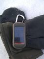
At the Zero
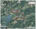
Route I walked when visiting the point.


Achievements
Pehku earned the Land geohash achievement
|
Pehku earned the Frozen Geohash Achievement
|
Pehku earned the Tron achievement
|
Pehku earned the Walk geohash Achievement
|