Difference between revisions of "2013-03-02 36 -79"
imported>Birdray m |
imported>FippeBot m (Location) |
||
| (3 intermediate revisions by one other user not shown) | |||
| Line 1: | Line 1: | ||
| + | [[Image:{{{image|2013-03-02_36_-79_2.jpg}}}|thumb|left]] | ||
| + | |||
{{meetup graticule | {{meetup graticule | ||
| lat=36 | | lat=36 | ||
| Line 10: | Line 12: | ||
== Participants == | == Participants == | ||
| − | [[User:Birdray|Birdray]] | + | * [[User:Birdray|Birdray]] |
| + | * Trusty friend Charlie | ||
== Plans == | == Plans == | ||
| Line 16: | Line 19: | ||
== Expedition == | == Expedition == | ||
| − | + | I picked up my friend Charlie and off we went to the hashpoint via car. (My phone, of course, crashed part of the way there, so my tracklog starts in an odd sort of place, where we pulled off the road at a gas station.) We passed by approximately 80,000 churches before arriving at the park where the hashpoint was located. | |
| + | |||
| + | We parked and followed the path a ways. To one side of the path were some birch saplings, with tiny birds flitting between the branches ahead of us as we walked. When we veered onto the field, the birds flew onto the field and joined a dozen more, and as we walked, the ones nearest us continually flew a little further on until there was a net of birds constantly rising and falling just ahead of us. | ||
| + | |||
| + | We stopped and did a series of little awkward steps to get as close to the hashpoint as we could. We took some pictures of the enthralling landscape of Oak Ridge. | ||
| + | |||
| + | We got back in the car and drove back to town. | ||
== Tracklog == | == Tracklog == | ||
| − | + | [http://www.everytrail.com/view_trip.php?trip_id=2035178 My tracklog on EveryTrail] | |
== Photos == | == Photos == | ||
| − | |||
| − | |||
| − | |||
<gallery perrow="5"> | <gallery perrow="5"> | ||
| + | Image:2013-03-02_36_-79_1.jpg | The Oak Ridge town hall and post office, right across from the park. Welcome to the heart of Oak Ridge. | ||
| + | Image:2013-03-02_36_-79_2.jpg | And us in front of the Oak Ridge town hall and post office. | ||
| + | Image:2013-03-02_36_-79_3.png | Us at the hashpoint. | ||
</gallery> | </gallery> | ||
== Achievements == | == Achievements == | ||
{{#vardefine:ribbonwidth|800px}} | {{#vardefine:ribbonwidth|800px}} | ||
| − | + | {{land geohash | |
| + | | latitude = 36 | ||
| + | | longitude = -79 | ||
| + | | date = 2013-03-02 | ||
| + | | name = [[User:Birdray|Birdray]] | ||
| + | | image = 2013-03-02 36 -79 2.jpg | ||
| + | }} | ||
| + | {{Minesweeper geohash | ||
| + | | graticule = Winston-Salem, North Carolina | ||
| + | | ranknumber = 2 | ||
| + | | e = true | ||
| + | | se = true | ||
| + | | name = [[User:Birdray|Birdray]] | ||
| + | }} | ||
| + | {{drag-along | ||
| + | | latitude = 36 | ||
| + | | longitude = -79 | ||
| + | | date = 2013-03-02 | ||
| + | | partner = Charlie | ||
| + | | name = [[User:Birdray|Birdray]] | ||
| + | | image = 2013-03-02 36 -79 2.jpg | ||
| + | }} | ||
| − | |||
| − | |||
| − | |||
| − | |||
[[Category:Expeditions]] | [[Category:Expeditions]] | ||
| − | |||
[[Category:Expeditions with photos]] | [[Category:Expeditions with photos]] | ||
| − | |||
| − | |||
| − | |||
| − | |||
| − | |||
[[Category:Coordinates reached]] | [[Category:Coordinates reached]] | ||
| − | + | {{location|US|NC|GU}} | |
| − | |||
| − | |||
| − | |||
| − | |||
| − | |||
| − | |||
| − | |||
| − | |||
| − | |||
| − | |||
| − | |||
| − | |||
| − | |||
| − | |||
| − | |||
| − | |||
| − | |||
Latest revision as of 01:12, 14 August 2019

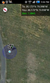
| Sat 2 Mar 2013 in 36,-79: 36.1726841, -79.9984565 geohashing.info google osm bing/os kml crox |
Location
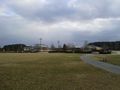
Just off a pathway in Oak Ridge Town Park.
Participants
- Birdray
- Trusty friend Charlie
Plans
Birdray plans to go at some point. Maybe a 4:00 meetup, maybe not. Anyone else?
Expedition
I picked up my friend Charlie and off we went to the hashpoint via car. (My phone, of course, crashed part of the way there, so my tracklog starts in an odd sort of place, where we pulled off the road at a gas station.) We passed by approximately 80,000 churches before arriving at the park where the hashpoint was located.
We parked and followed the path a ways. To one side of the path were some birch saplings, with tiny birds flitting between the branches ahead of us as we walked. When we veered onto the field, the birds flew onto the field and joined a dozen more, and as we walked, the ones nearest us continually flew a little further on until there was a net of birds constantly rising and falling just ahead of us.
We stopped and did a series of little awkward steps to get as close to the hashpoint as we could. We took some pictures of the enthralling landscape of Oak Ridge.
We got back in the car and drove back to town.
Tracklog
Photos
The Oak Ridge town hall and post office, right across from the park. Welcome to the heart of Oak Ridge.

And us in front of the Oak Ridge town hall and post office.
Us at the hashpoint.


Achievements
Birdray earned the Land geohash achievement
|
Birdray achieved level 2 of the Minesweeper Geohash achievement
|
Birdray earned the Drag-along achievement
|