Difference between revisions of "2013-03-03 47 7"
imported>TheOneRing (Created page with "{{meetup graticule | lat=47 | lon=7 | date=2013-03-03 }} == Location == The geohash is at Brüttelen near a street to Ins (canton Bern). == Who Went == [[User:TheOneRing|The...") |
imported>TheOneRing |
||
| Line 11: | Line 11: | ||
[[User:TheOneRing|TheOneRing]] - by public transport. | [[User:TheOneRing|TheOneRing]] - by public transport. | ||
| − | == The | + | == The Expedition == |
| − | I | + | The weather seemed to be like forecastet: foggy. Unfortunately, this was confirmed when I reached Ins. Ok, no problem, at least no rain. |
| + | |||
| + | I left the train station and checked the map and my eTrex. The way to the geohash led through the village of Ins. When I left Ins, also the pavement ended and I had to walk aside the raod. Approximately 800m to the geohash, there was a farm track parallel to the street and I chose to walk there. | ||
| + | |||
| + | The geohash itself was then around 60m on a field next to the farm track. I don't know what will grow there, the plants were still to small. But due to the humid conditions because of the fog and melting snow, the field was muddy. | ||
| + | |||
| + | The necessary photographs I took at the geohash, but some more from the farm track, because I did not want to destroy any (or more) plants. Finally, I walked back to Ins and from there went back to Bern by train. | ||
== Photos == | == Photos == | ||
| + | <gallery perrow="4"> | ||
| + | Image:20130303_47_7Train.jpg|The train to Ins | ||
| + | Image:20130303_47_7Geohash.jpg|On this field there is the geohash | ||
| + | Image:20130303_47_7GPS.jpg|Coordinates reached | ||
| + | Image:20130303_47_7Info.jpg|Some more information | ||
| + | Image:20130303_47_7Me.jpg|The happy hasher | ||
| + | Image:20130303_47_7Surrounding.jpg|A 180deg panoramic view around the geohash | ||
| + | </gallery> | ||
== Achievements == | == Achievements == | ||
| + | {{land geohash | latitude = 47 | longitude = 7 | date = 2013-03-03 | name = TheOneRing }} | ||
| + | {{Public transport geohash | latitude = 47 | longitude = 7 | date = 2013-03-03 | name = TheOneRing}} | ||
| + | |||
| + | [[Category:Expeditions]] | ||
| + | [[Category:Expeditions with photos]] | ||
| + | [[Category:Coordinates reached]] | ||
Revision as of 13:55, 3 March 2013
| Sun 3 Mar 2013 in 47,7: 47.0160004, 7.1443803 geohashing.info google osm bing/os kml crox |
Location
The geohash is at Brüttelen near a street to Ins (canton Bern).
Who Went
TheOneRing - by public transport.
The Expedition
The weather seemed to be like forecastet: foggy. Unfortunately, this was confirmed when I reached Ins. Ok, no problem, at least no rain.
I left the train station and checked the map and my eTrex. The way to the geohash led through the village of Ins. When I left Ins, also the pavement ended and I had to walk aside the raod. Approximately 800m to the geohash, there was a farm track parallel to the street and I chose to walk there.
The geohash itself was then around 60m on a field next to the farm track. I don't know what will grow there, the plants were still to small. But due to the humid conditions because of the fog and melting snow, the field was muddy.
The necessary photographs I took at the geohash, but some more from the farm track, because I did not want to destroy any (or more) plants. Finally, I walked back to Ins and from there went back to Bern by train.
Photos
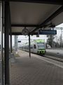
The train to Ins
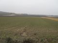
On this field there is the geohash
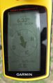
Coordinates reached
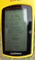
Some more information

The happy hasher
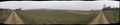
A 180deg panoramic view around the geohash


Achievements
TheOneRing earned the Land geohash achievement
|
TheOneRing earned the Public transport geohash achievement
|