Difference between revisions of "2013-02-27 45 -122"
From Geohashing
imported>Jiml (Add some details) |
imported>FippeBot m (Location) |
||
| (2 intermediate revisions by one other user not shown) | |||
| Line 23: | Line 23: | ||
== Participants == | == Participants == | ||
| − | * [[User:Jiml| | + | * [[User:Jiml|Jim]] |
== Plans == | == Plans == | ||
| Line 45: | Line 45: | ||
<gallery perrow="5"> | <gallery perrow="5"> | ||
| + | Image:2012-02-27 45 -122 GPS.jpg|Proof that the GPS didn't make it to the hashpoint | ||
| + | Image:2012-02-27 45 -122 Hashpoint.jpg|A view towards the hashpoint we didn't go to | ||
</gallery> | </gallery> | ||
| Line 57: | Line 59: | ||
[[Category:Retro coordinates not reached]] | [[Category:Retro coordinates not reached]] | ||
[[Category:Not reached - No public access]] | [[Category:Not reached - No public access]] | ||
| + | {{location|US|OR|WI}} | ||
Latest revision as of 01:09, 14 August 2019
| Wed 27 Feb 2013 in 45,-122: 45.5984678, -122.9566034 geohashing.info google osm bing/os kml crox |
Location
Farmland north of Hwy 26 near Hillsboro
Participants
Plans
I was going to try to wander the road near this hashpoint on my way home, but was just too tired by the time I finally got to my car at the end of the line. So I put it off for a later adventure.
Expedition
On Saturday, I was feeling a little more energetic, so after visiting the Winter Farmer's market and the bakery, I wandered by the hashpoint.
I wasn't the least bit surprised to find it on private land. I took a couple of photos and headed for the gym and home.
Photos
In the camera for a bit
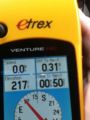
Proof that the GPS didn't make it to the hashpoint
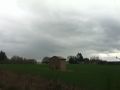
A view towards the hashpoint we didn't go to


Achievements
- No Trespassing?