Difference between revisions of "2013-03-09 52 13"
imported>Karasu (→Plans) |
imported>Karasu (→Tracklog) |
||
| Line 41: | Line 41: | ||
== Tracklog == | == Tracklog == | ||
<!-- if your GPS device keeps a log, you may post a link here --> | <!-- if your GPS device keeps a log, you may post a link here --> | ||
| + | Had some issues with my GPS taking ages to get a satellite feed so only a short log was taken from the bus station to the hash. I see no need to post it here and am not quite sure where to do so in case I want to. So I might add it somewhen... | ||
== Photos == | == Photos == | ||
Revision as of 16:46, 9 March 2013
| Sat 9 Mar 2013 in 52,13: 52.3306481, 13.6416891 geohashing.info google osm bing/os kml crox |
Location
This days hash is outskirts of Berlin near the village Zeuthen,
easily accesible via public transportation
with the nearest station being S-Bhf Wildau.
- Expectation:
The hash is located on the edge of a small forest, very close to a river - Reality:
The hash was roughly 2m off the riverside just within the water.
Participants
Plans
I just recently found out about geo hashing and finally got interestedin visiting one myself. So I waited for the weekend which brought me this easy hash, accesible via public transportation and a brief walk.
Expedition
- Proudly reached my first hash -- Karasu (talk) @52.3306,13.6417 14:52, 9 March 2013 (CET)
Tracklog
Had some issues with my GPS taking ages to get a satellite feed so only a short log was taken from the bus station to the hash. I see no need to post it here and am not quite sure where to do so in case I want to. So I might add it somewhen...
Photos
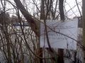
I left a sign hoping the water police that was just passing by wont mind
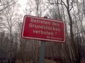
The mayor personally informed me not to tresspass... allthough no raptor warnings were issued
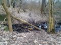
The closest thing to an adventure: a little bit of balancing as not to get your feet dirty


Achievements