Difference between revisions of "2013-03-10 48 12"
imported>Knallgöwer (→Location) |
imported>Palmpje m (Clean up of new report category) |
||
| Line 58: | Line 58: | ||
| − | <!-- =============== USEFUL CATEGORIES FOLLOW ================ | + | <!-- =============== USEFUL CATEGORIES FOLLOW ================ --> |
| − | |||
| − | |||
| − | |||
| − | |||
| − | |||
| − | |||
| − | |||
| − | |||
| − | |||
[[Category:Expeditions]] | [[Category:Expeditions]] | ||
| − | |||
[[Category:Expeditions with photos]] | [[Category:Expeditions with photos]] | ||
| − | |||
| − | |||
| − | |||
| − | |||
| − | |||
[[Category:Coordinates reached]] | [[Category:Coordinates reached]] | ||
| − | |||
| − | |||
| − | |||
| − | |||
| − | |||
| − | |||
| − | |||
| − | |||
| − | |||
| − | |||
| − | |||
| − | |||
| − | |||
| − | |||
| − | |||
| − | |||
| − | |||
| − | |||
Revision as of 10:44, 3 June 2013
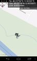
| Sun 10 Mar 2013 in 48,12: 48.0379557, 12.8232070 geohashing.info google osm bing/os kml crox |
Location
A forest surrounding the river Salzach which marks the German Austrian border north of Salzburg.
Participants
Plans
- Plan for tomorrow: reaching two geohashs on one day in 48 11 and 48 12 on my way visiting a friend close to Salzburg -- Knallgöwer (talk) @48.3339,11.6562 15:05, 9 March 2013 (CET)
Expedition
After reaching the 48 11 hash in the morning and visiting a friend during the day I decided to try the next hash as well, although it would be dark until I get there. I passed the Austrian border and about 30 km north of Salzburg just west of the village Ostermiethen I stopped my car at the beginning of the forest close to the river Salzach, which marks the border between Germany and Austria. The hash was hard to get to, because a quite broad stream leading to the river blocked the way. And especially because of the total darkness and the upcoming thunderstorm it was kind of creepy in the forest :-) The massive number of small frogs did the rest to create a frightening atmosphere. Just as I found the hash, it started to rain like hell and so I hurried to take some more photos before I ran back to the car being all drained and wet...again!! But it was really amazing to visit two hashs (in different countries!) in one day...
Tracklog
Photos
Wohoo! @48.0380,12.8233
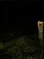
Found the hash in the woods
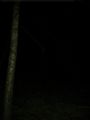
Night time in the woods - it IS creepy
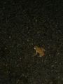
Lots of those little fellas because of the starting rain

Mission accomplished...and getting wet again!


