Difference between revisions of "2013-03-10 48 12"
imported>Knallgöwer (→Expedition) |
imported>FippeBot m (Location) |
||
| (5 intermediate revisions by 3 users not shown) | |||
| Line 1: | Line 1: | ||
| − | |||
| − | |||
| − | |||
| − | |||
| − | |||
| − | |||
| − | |||
| − | |||
| − | |||
| − | |||
{{meetup graticule | {{meetup graticule | ||
| lat=48 | | lat=48 | ||
| Line 19: | Line 9: | ||
== Location == | == Location == | ||
<!-- where you've surveyed the hash to be --> | <!-- where you've surveyed the hash to be --> | ||
| + | A forest surrounding the river Salzach which marks the German Austrian border north of Salzburg. | ||
== Participants == | == Participants == | ||
| Line 26: | Line 17: | ||
== Plans == | == Plans == | ||
<!-- what were the original plans --> | <!-- what were the original plans --> | ||
| + | *Plan for tomorrow: reaching two geohashs on one day in 48 11 and 48 12 on my way visiting a friend close to Salzburg -- [[User:Knallgöwer|Knallgöwer]] ([[User talk:Knallgöwer|talk]]) [http://www.openstreetmap.org/?lat=48.33387561&lon=11.65616880&zoom=16&layers=B000FTF @48.3339,11.6562] 15:05, 9 March 2013 (CET) | ||
== Expedition == | == Expedition == | ||
<!-- how it all turned out. your narrative goes here. --> | <!-- how it all turned out. your narrative goes here. --> | ||
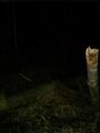
| + | After reaching the [[2013-03-10 48 11 |48 11]] hash in the morning and visiting a friend during the day I decided to try the next hash as well, although it would be dark until I get there. I passed the Austrian border and about 30 km north of Salzburg just west of the village Ostermiethen I stopped my car at the beginning of the forest close to the river Salzach, which marks the border between Germany and Austria. The hash was hard to get to, because a quite broad stream leading to the river blocked the way. And especially because of the total darkness and the upcoming thunderstorm it was kind of creepy in the forest :-) The massive number of small frogs did the rest to create a frightening atmosphere. Just as I found the hash, it started to rain like hell and so I hurried to take some more photos before I ran back to the car being all drained and wet...again!! But it was really amazing to visit two hashs (in different countries!) in one day... | ||
== Tracklog == | == Tracklog == | ||
| Line 54: | Line 47: | ||
<!-- Add any achievement ribbons you earned below, or remove this section --> | <!-- Add any achievement ribbons you earned below, or remove this section --> | ||
| − | |||
| − | |||
| − | |||
| − | |||
| − | |||
| − | |||
| − | |||
| − | |||
| − | |||
| − | |||
| − | |||
[[Category:Expeditions]] | [[Category:Expeditions]] | ||
| − | |||
[[Category:Expeditions with photos]] | [[Category:Expeditions with photos]] | ||
| − | |||
| − | |||
| − | |||
| − | |||
| − | |||
[[Category:Coordinates reached]] | [[Category:Coordinates reached]] | ||
| − | + | {{location|AT|OÖ|BR}} | |
| − | |||
| − | |||
| − | |||
| − | |||
| − | |||
| − | |||
| − | |||
| − | |||
| − | |||
| − | |||
| − | |||
| − | |||
| − | |||
| − | |||
| − | |||
| − | |||
| − | |||
Latest revision as of 01:22, 14 August 2019
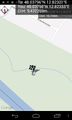
| Sun 10 Mar 2013 in 48,12: 48.0379557, 12.8232070 geohashing.info google osm bing/os kml crox |
Location
A forest surrounding the river Salzach which marks the German Austrian border north of Salzburg.
Participants
Plans
- Plan for tomorrow: reaching two geohashs on one day in 48 11 and 48 12 on my way visiting a friend close to Salzburg -- Knallgöwer (talk) @48.3339,11.6562 15:05, 9 March 2013 (CET)
Expedition
After reaching the 48 11 hash in the morning and visiting a friend during the day I decided to try the next hash as well, although it would be dark until I get there. I passed the Austrian border and about 30 km north of Salzburg just west of the village Ostermiethen I stopped my car at the beginning of the forest close to the river Salzach, which marks the border between Germany and Austria. The hash was hard to get to, because a quite broad stream leading to the river blocked the way. And especially because of the total darkness and the upcoming thunderstorm it was kind of creepy in the forest :-) The massive number of small frogs did the rest to create a frightening atmosphere. Just as I found the hash, it started to rain like hell and so I hurried to take some more photos before I ran back to the car being all drained and wet...again!! But it was really amazing to visit two hashs (in different countries!) in one day...
Tracklog
Photos
Wohoo! @48.0380,12.8233
Found the hash in the woods

Night time in the woods - it IS creepy

Lots of those little fellas because of the starting rain

Mission accomplished...and getting wet again!


