Difference between revisions of "2013-03-12 60 22"
imported>Suurnesu ([http://www.openstreetmap.org/?lat=60.39726750&lon=22.17635259&zoom=16&layers=B000FTF @60.3973,22.1764]) |
imported>Suurnesu |
||
| Line 1: | Line 1: | ||
| − | |||
| − | |||
| − | |||
| − | |||
| − | |||
| − | |||
| − | |||
| − | |||
{{meetup graticule | {{meetup graticule | ||
| lat=60 | | lat=60 | ||
| Line 18: | Line 10: | ||
__NOTOC__ | __NOTOC__ | ||
== Location == | == Location == | ||
| − | + | Again the hashpoint happened to land on one of Turku's islands. This time it was in a small field in the Island of Hirvensalo. | |
== Participants == | == Participants == | ||
| − | + | * [[User:Suurnesu|Suurnesu]] | |
| − | |||
| − | |||
| − | |||
| − | |||
== Expedition == | == Expedition == | ||
| − | + | I noticed that the hashpoint is again quite easy to reach. I would have liked to go there during daylight but unfortunately it was already dark at 21 when I was able to leave home. | |
| − | + | I drove to Hirvensalo and during the ride it begun to snow. Snowing was quite light, however, and I had no problems reaching the place. | |
| − | + | I left my car at a bus stop. Then I continued towards the zero point on foot. It was only about 35 meters from the road. There was quite a lot of snow on the field. I had my long winter boots but still I managed to get some snow inside the boots. At some points there was snow up to my knees. | |
| − | + | Navigating was easy and I managed to get into a position where my GPS showed 0m. | |
| + | It was peaceful and dark. Only one car passed the place while I was trying to take pictures. No other tracks in the snow this time. Nice geohash again! :) | ||
== Photos == | == Photos == | ||
| Line 39: | Line 28: | ||
<gallery perrow="5"> | <gallery perrow="5"> | ||
| − | Image:2013-03-12_60_22_21-05-55-625.jpg | | + | Image:2013-03-12_60_22_21-05-55-625.jpg | Uuuuh! How lovely geohash! |
| − | Image:2013-03-12_60_22_21-06-36-258.jpg | | + | Image:2013-03-12_60_22_21-06-36-258.jpg | Screen capture from NeonGeo |
| − | |||
| − | + | Image:60_22_12_03_2013_1.jpg | I wrote my greetings to the snow | |
| − | |||
| − | |||
| + | Image:60_22_12_03_2013_2.jpg | Footprints in the snow leading to the zero point | ||
| − | + | Image:60_22_12_03_2013_3.jpg | View towards the road across the field | |
| − | + | ||
| − | + | Image:60_22_12_03_2013_4.jpg | Another view | |
| + | </gallery> | ||
| − | |||
| − | |||
| − | |||
| − | |||
| − | |||
[[Category:Expeditions]] | [[Category:Expeditions]] | ||
| − | + | [[Category:Expeditions with photos]] | |
| − | [[Category:Expeditions with photos]] | ||
| − | |||
| − | |||
| − | |||
| − | |||
| − | |||
[[Category:Coordinates reached]] | [[Category:Coordinates reached]] | ||
| − | |||
| − | |||
| − | |||
| − | |||
| − | |||
| − | |||
| − | |||
| − | |||
| − | |||
| − | |||
| − | |||
| − | |||
| − | |||
| − | |||
| − | |||
| − | |||
| − | |||
| − | |||
Revision as of 20:02, 12 March 2013
| Tue 12 Mar 2013 in 60,22: 60.3972633, 22.1765148 geohashing.info google osm bing/os kml crox |
Location
Again the hashpoint happened to land on one of Turku's islands. This time it was in a small field in the Island of Hirvensalo.
Participants
Expedition
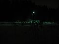
I noticed that the hashpoint is again quite easy to reach. I would have liked to go there during daylight but unfortunately it was already dark at 21 when I was able to leave home. I drove to Hirvensalo and during the ride it begun to snow. Snowing was quite light, however, and I had no problems reaching the place. I left my car at a bus stop. Then I continued towards the zero point on foot. It was only about 35 meters from the road. There was quite a lot of snow on the field. I had my long winter boots but still I managed to get some snow inside the boots. At some points there was snow up to my knees. Navigating was easy and I managed to get into a position where my GPS showed 0m. It was peaceful and dark. Only one car passed the place while I was trying to take pictures. No other tracks in the snow this time. Nice geohash again! :)
Photos

Uuuuh! How lovely geohash!
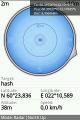
Screen capture from NeonGeo
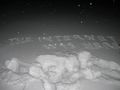
I wrote my greetings to the snow
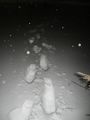
Footprints in the snow leading to the zero point
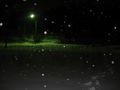
View towards the road across the field
Another view


