Difference between revisions of "2013-03-21 61 23"
imported>Teukkam ([live picture] South. [http://www.openstreetmap.org/?lat=61.59120000&lon=23.61500000&zoom=16&layers=B000FTF @61.5912,23.6150]) |
imported>FippeBot m (Location) |
||
| (7 intermediate revisions by one other user not shown) | |||
| Line 27: | Line 27: | ||
== Plans == | == Plans == | ||
| − | + | *Less than 10 km away from work, might give it a try. -- [[User:Teukkam|TeukkaM]] ([[User talk:Teukkam|talk]]) 15:37, 20 March 2013 (EET) | |
| + | *Park near Antaverkantie / Vahannantie crossing, then continue on foot to the hashpoint. | ||
== Expedition == | == Expedition == | ||
| − | + | I parked my car at the level of the industrial compound and started to make my way through the snow. There were rabbit tracks going towards the hashpoint and I was excited to see if a rabbit geohasher had already reached the hashpoint. Unfortunately, an adult male geohasher weighs more than a rabbit, thus I ended up falling knee-deep in the snow every few steps. It would probably have been easier to walk along the fence of the industrial compound but the signs about video surveillance made me decide otherwise. I finally reached the hashpoint on the snow covered field (the rabbit had turned into the woods so I was the first living being to reach it today), took some photos and wrote the largest xkcd message so far. On my way back I contemplated leaving a message at the postbox of the house the field seemed to belong to, but decided it wasn't necessary. Snow covered field are covered by the freedom to roam, so I wasn't actually trespassing. | |
| − | |||
| − | |||
== Tracklog == | == Tracklog == | ||
<!-- if your GPS device keeps a log, you may post a link here --> | <!-- if your GPS device keeps a log, you may post a link here --> | ||
| Line 44: | Line 43: | ||
Image:2013-03-21_61_23_09-27-24-128.jpg | South. [http://www.openstreetmap.org/?lat=61.59120000&lon=23.61500000&zoom=16&layers=B000FTF @61.5912,23.6150] | Image:2013-03-21_61_23_09-27-24-128.jpg | South. [http://www.openstreetmap.org/?lat=61.59120000&lon=23.61500000&zoom=16&layers=B000FTF @61.5912,23.6150] | ||
| + | |||
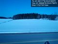
| + | Image:2013-03-21_61_23_09-27-54-246.jpg | West [http://www.openstreetmap.org/?lat=61.59120000&lon=23.61500000&zoom=16&layers=B000FTF @61.5912,23.6150] | ||
| + | |||
| + | Image:2013-03-21_61_23_09-29-00-101.jpg | North. My tracks, a lone pine and the industrial compound. [http://www.openstreetmap.org/?lat=61.59120000&lon=23.61500000&zoom=16&layers=B000FTF @61.5912,23.6150] | ||
| + | |||
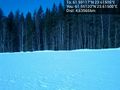
| + | Image:2013-03-21_61_23_09-29-41-782.jpg | East. Some hay bales. [http://www.openstreetmap.org/?lat=61.59120000&lon=23.61500000&zoom=16&layers=B000FTF @61.5912,23.6150] | ||
| + | |||
| + | Image:2013-03-21_61_23_09-37-07-986.jpg | The message. [http://www.openstreetmap.org/?lat=61.59120024&lon=23.61503863&zoom=16&layers=B000FTF @61.5912,23.6150] | ||
| + | |||
| + | Image:2013-03-21_61_23_09-45-04-559.jpg | The message is clearly visible from the main road. I note realise I should have written it the other way around. Oh well. [http://www.openstreetmap.org/?lat=61.59040000&lon=23.61790000&zoom=16&layers=B000FTF @61.5904,23.6179] | ||
| + | |||
| + | Image:2013-03-21_61_23_09-47-50-744.jpg | "Horses on the road". None were sighted. [http://www.openstreetmap.org/?lat=61.59030000&lon=23.61870000&zoom=16&layers=B000FTF @61.5903,23.6187] | ||
</gallery> | </gallery> | ||
| Line 51: | Line 62: | ||
| − | |||
| − | |||
| − | |||
| − | |||
| − | |||
| − | |||
| − | |||
| − | |||
| − | |||
[[Category:Expeditions]] | [[Category:Expeditions]] | ||
| − | |||
[[Category:Expeditions with photos]] | [[Category:Expeditions with photos]] | ||
| − | |||
| − | |||
| − | |||
| − | |||
| − | |||
[[Category:Coordinates reached]] | [[Category:Coordinates reached]] | ||
| − | + | {{location|FI|11}} | |
| − | |||
| − | |||
| − | |||
| − | |||
| − | |||
| − | |||
| − | |||
| − | |||
| − | |||
| − | |||
| − | |||
| − | |||
| − | |||
| − | |||
| − | |||
| − | |||
| − | |||
Latest revision as of 01:29, 14 August 2019
| Thu 21 Mar 2013 in 61,23: 61.5911662, 23.6150509 geohashing.info google osm bing/os kml crox |
Location
On a field in Ylöjärvi, just outside the fence of a small industrial compound.
Participants
Plans
- Less than 10 km away from work, might give it a try. -- TeukkaM (talk) 15:37, 20 March 2013 (EET)
- Park near Antaverkantie / Vahannantie crossing, then continue on foot to the hashpoint.
Expedition
I parked my car at the level of the industrial compound and started to make my way through the snow. There were rabbit tracks going towards the hashpoint and I was excited to see if a rabbit geohasher had already reached the hashpoint. Unfortunately, an adult male geohasher weighs more than a rabbit, thus I ended up falling knee-deep in the snow every few steps. It would probably have been easier to walk along the fence of the industrial compound but the signs about video surveillance made me decide otherwise. I finally reached the hashpoint on the snow covered field (the rabbit had turned into the woods so I was the first living being to reach it today), took some photos and wrote the largest xkcd message so far. On my way back I contemplated leaving a message at the postbox of the house the field seemed to belong to, but decided it wasn't necessary. Snow covered field are covered by the freedom to roam, so I wasn't actually trespassing.
Tracklog
Photos
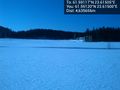
South. @61.5912,23.6150
West @61.5912,23.6150
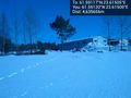
North. My tracks, a lone pine and the industrial compound. @61.5912,23.6150

East. Some hay bales. @61.5912,23.6150

The message. @61.5912,23.6150
The message is clearly visible from the main road. I note realise I should have written it the other way around. Oh well. @61.5904,23.6179
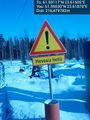
"Horses on the road". None were sighted. @61.5903,23.6187


