Difference between revisions of "2013-03-28 47 -122"
imported>Thomcat ([live] At the bank - geohash nearby!) |
imported>FippeBot m (Location) |
||
| (7 intermediate revisions by one other user not shown) | |||
| Line 1: | Line 1: | ||
| − | |||
| − | |||
| − | |||
| − | |||
| − | |||
| − | |||
| − | |||
| − | |||
| − | |||
| − | |||
{{meetup graticule | {{meetup graticule | ||
| lat=47 | | lat=47 | ||
| lon=-122 | | lon=-122 | ||
| date=2013-03-28 | | date=2013-03-28 | ||
| + | | graticule_name=Seattle | ||
| + | | graticule_link=Seattle, Washington | ||
}} | }} | ||
| Line 18: | Line 10: | ||
__NOTOC__ | __NOTOC__ | ||
== Location == | == Location == | ||
| − | + | The southern boundary of a field in Kirkland. | |
== Participants == | == Participants == | ||
| − | + | * [[User:Thomcat|Thomcat]] | |
| − | |||
== Plans == | == Plans == | ||
| − | + | Stop by after work, then take the toll bridge back to Seattle. | |
== Expedition == | == Expedition == | ||
| − | + | *At the bank - geohash nearby! -- [[User:Thomcat|Thomcat]] ([[User talk:Thomcat|talk]]) [http://www.openstreetmap.org/?lat=47.67915927&lon=-122.16898283&zoom=16&layers=B000FTF @47.6792,-122.1690] 16:55, 28 March 2013 (PDT) | |
| + | |||
| + | As you can see, the bank was very close to the spot. Drove a bit south, then around past a school zone, and down a very narrow road. By driving right next to the fence, I parked on the spot... or did I? Once parked, the spot began drifting away from me - headed east! Also, I had very little cell reception, despite being mostly in the open. | ||
| + | |||
| + | *7m north - time to try from the other side -- [[User:Thomcat|Thomcat]] ([[User talk:Thomcat|talk]]) [http://www.openstreetmap.org/?lat=47.67166960&lon=-122.17026213&zoom=16&layers=B000FTF @47.6717,-122.1703] 17:02, 28 March 2013 (PDT) | ||
| + | |||
| + | That is because the field had several radio transmission towers, and associated high power wires leading in also. I drove around to the south side, thinking I could walk across the field, though the barbed wire along the top of the north fence led me to think that wouldn't be the case. | ||
| + | |||
| + | ... and it wasn't. Driving up to the gate, I saw the cell signal drop one bar per 10 meters or so, and parked in front of the gate I couldn't connect at all. Since my current GPS is my Android phone, I was able to get a location (after it gave up on cell signal) but unable to upload to the site (until I backed up 20 meters from the gate). | ||
| + | Did I reach the spot? Later satellite photo analysis shows the spot to be just inside the fence, and while I leaned on the fence, I didn't get inside. The spot is certainly less that 7 meters away from where I was (that was drift) but I also wasn't on it, measurement devices be damned. +1 expedition, but no success this time. | ||
| − | + | Happy Easter everybody! | |
| − | |||
| − | |||
== Photos == | == Photos == | ||
| − | |||
| − | |||
| − | |||
<gallery perrow="5"> | <gallery perrow="5"> | ||
| + | Image:2013-03-28 47 -122 Nearby.jpg | Parked next to the fence | ||
| + | Image:2013-03-28 47 -122 OverThere.jpg | The geohash is through that brush | ||
| + | Image:2013-03-28 47 -122 Parked.jpg | How close to the fence? | ||
| + | |||
| + | Image:2013-03-28_47_-122_17-17-20-178.jpg | KARR 1460 AM says no trespassing [http://www.openstreetmap.org/?lat=47.67399977&lon=-122.16939805&zoom=16&layers=B000FTF @47.6740,-122.1694] | ||
</gallery> | </gallery> | ||
== Achievements == | == Achievements == | ||
{{#vardefine:ribbonwidth|800px}} | {{#vardefine:ribbonwidth|800px}} | ||
| − | + | {{No trespassing |latitude= 47 |longitude= -122 |date= 2013-03-28 |image= 2013-03-28_47_-122_17-17-20-178.jpg |name= Thomcat |distance= }} | |
| − | |||
| − | |||
| − | |||
| − | |||
| − | |||
| − | |||
| − | |||
| − | |||
| − | |||
| − | |||
| − | |||
[[Category:Expeditions]] | [[Category:Expeditions]] | ||
| − | |||
[[Category:Expeditions with photos]] | [[Category:Expeditions with photos]] | ||
| − | |||
| − | |||
| − | |||
| − | |||
| − | |||
| − | |||
| − | |||
| − | |||
| − | |||
[[Category:Coordinates not reached]] | [[Category:Coordinates not reached]] | ||
| − | |||
| − | |||
| − | |||
| − | |||
| − | |||
[[Category:Not reached - No public access]] | [[Category:Not reached - No public access]] | ||
| − | + | {{location|US|WA|KN}} | |
| − | |||
| − | |||
| − | |||
| − | |||
| − | |||
| − | |||
| − | |||
Latest revision as of 01:38, 14 August 2019
| Thu 28 Mar 2013 in Seattle: 47.6717396, -122.1702692 geohashing.info google osm bing/os kml crox |
Location
The southern boundary of a field in Kirkland.
Participants
Plans
Stop by after work, then take the toll bridge back to Seattle.
Expedition
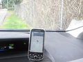
- At the bank - geohash nearby! -- Thomcat (talk) @47.6792,-122.1690 16:55, 28 March 2013 (PDT)
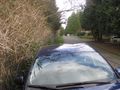
As you can see, the bank was very close to the spot. Drove a bit south, then around past a school zone, and down a very narrow road. By driving right next to the fence, I parked on the spot... or did I? Once parked, the spot began drifting away from me - headed east! Also, I had very little cell reception, despite being mostly in the open.
- 7m north - time to try from the other side -- Thomcat (talk) @47.6717,-122.1703 17:02, 28 March 2013 (PDT)
That is because the field had several radio transmission towers, and associated high power wires leading in also. I drove around to the south side, thinking I could walk across the field, though the barbed wire along the top of the north fence led me to think that wouldn't be the case.
... and it wasn't. Driving up to the gate, I saw the cell signal drop one bar per 10 meters or so, and parked in front of the gate I couldn't connect at all. Since my current GPS is my Android phone, I was able to get a location (after it gave up on cell signal) but unable to upload to the site (until I backed up 20 meters from the gate).
Did I reach the spot? Later satellite photo analysis shows the spot to be just inside the fence, and while I leaned on the fence, I didn't get inside. The spot is certainly less that 7 meters away from where I was (that was drift) but I also wasn't on it, measurement devices be damned. +1 expedition, but no success this time.
Happy Easter everybody!
Photos
Parked next to the fence
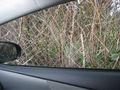
The geohash is through that brush
How close to the fence?
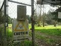
KARR 1460 AM says no trespassing @47.6740,-122.1694


Achievements
Thomcat earned the No trespassing consolation prize
|