Difference between revisions of "2013-04-02 45 -111"
From Geohashing
imported>Davidfg4 (add info) |
imported>Davidfg4 (→Photos: add photos) |
||
| Line 40: | Line 40: | ||
Image:2012-##-## ## ## Alpha.jpg | Witty Comment | Image:2012-##-## ## ## Alpha.jpg | Witty Comment | ||
--> | --> | ||
| − | <gallery perrow=" | + | <gallery perrow="4"> |
| + | Image:2013-04-02_45_-111_davidfg4_gps.jpeg | GPS proof | ||
| + | Image:2013-04-02_45_-111_davidfg4_view.jpeg | A rather limited but lovely view of town. | ||
</gallery> | </gallery> | ||
Revision as of 23:06, 2 April 2013
| Tue 2 Apr 2013 in 45,-111: 45.7180351, -111.0166102 geohashing.info google osm bing/os kml crox |
Location
North of Bozeman, 200 feet off of Valley Ridge Road at the edge of a field.
Participants
Plans
I saw the location this morning and decided to grab it for how close it was.
Expedition
It was an easy drive to 200 ft of the location. I was originally worried that the field would be fenced, or there would be houses nearby, but neither of those were the case. The road is completely devoid of houses, although there is electric and gas set up for about 10 to be built. After photographing the location I drove down the rest of the road for OSM and mapped it.
On they way home I nabbed Hang Up and Drive 10, GC3BZ3C.
Tracklog
Photos
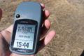
GPS proof

A rather limited but lovely view of town.

