Difference between revisions of "2013-04-02 45 -111"
From Geohashing
imported>Davidfg4 (let's try that again) |
imported>FippeBot m (Location) |
||
| (3 intermediate revisions by one other user not shown) | |||
| Line 18: | Line 18: | ||
__NOTOC__ | __NOTOC__ | ||
== Location == | == Location == | ||
| − | + | North of Bozeman, 200 feet off of Valley Ridge Road at the edge of a field. | |
== Participants == | == Participants == | ||
<!-- who attended: If you link to your wiki user name in this section, your expedition will be picked up by the various statistics generated for geohashing. You may use three tildes ~ as a shortcut to automatically insert the user signature of the account you are editing with. | <!-- who attended: If you link to your wiki user name in this section, your expedition will be picked up by the various statistics generated for geohashing. You may use three tildes ~ as a shortcut to automatically insert the user signature of the account you are editing with. | ||
--> | --> | ||
| + | [[User:davidfg4|davidfg4]] | ||
== Plans == | == Plans == | ||
| − | + | I saw the location this morning and decided to grab it for how close it was. | |
== Expedition == | == Expedition == | ||
| − | + | It was an easy drive to 200 ft of the location. I was originally worried that the field would be fenced, or there would be houses nearby, but neither of those were the case. The road is completely devoid of houses, although there is electric and gas set up for about 10 to be built. After photographing the location I drove down the rest of the road for OSM and mapped it. | |
| + | |||
| + | On they way home I nabbed [http://www.geocaching.com/seek/cache_details.aspx?guid=59812064-9387-4127-9309-7bbdb4c2b6f6 Hang Up and Drive 10, GC3BZ3C]. | ||
== Tracklog == | == Tracklog == | ||
| Line 37: | Line 40: | ||
Image:2012-##-## ## ## Alpha.jpg | Witty Comment | Image:2012-##-## ## ## Alpha.jpg | Witty Comment | ||
--> | --> | ||
| − | <gallery perrow=" | + | <gallery perrow="4"> |
| + | Image:2013-04-02_45_-111_davidfg4_gps.jpeg | GPS proof | ||
| + | Image:2013-04-02_45_-111_davidfg4_view.jpeg | A rather limited but lovely view of town. | ||
</gallery> | </gallery> | ||
| Line 43: | Line 48: | ||
{{#vardefine:ribbonwidth|800px}} | {{#vardefine:ribbonwidth|800px}} | ||
<!-- Add any achievement ribbons you earned below, or remove this section --> | <!-- Add any achievement ribbons you earned below, or remove this section --> | ||
| − | |||
| − | |||
| − | |||
| − | |||
| − | |||
| − | |||
| − | |||
| − | |||
| − | |||
| − | |||
<!-- An actual expedition: | <!-- An actual expedition: | ||
| Line 61: | Line 56: | ||
[[Category:Expedition without GPS]] | [[Category:Expedition without GPS]] | ||
--> | --> | ||
| − | + | ||
| − | + | [[Category:Expeditions]] | |
[[Category:Coordinates reached]] | [[Category:Coordinates reached]] | ||
| − | + | [[Category:Expeditions with photos]] | |
| − | + | {{location|US|MT|GL}} | |
| − | |||
| − | [[Category: | ||
| − | |||
| − | |||
| − | |||
| − | |||
| − | |||
| − | |||
| − | |||
| − | |||
| − | |||
| − | |||
| − | |||
| − | |||
| − | |||
| − | |||
Latest revision as of 01:43, 14 August 2019
| Tue 2 Apr 2013 in 45,-111: 45.7180351, -111.0166102 geohashing.info google osm bing/os kml crox |
Location
North of Bozeman, 200 feet off of Valley Ridge Road at the edge of a field.
Participants
Plans
I saw the location this morning and decided to grab it for how close it was.
Expedition
It was an easy drive to 200 ft of the location. I was originally worried that the field would be fenced, or there would be houses nearby, but neither of those were the case. The road is completely devoid of houses, although there is electric and gas set up for about 10 to be built. After photographing the location I drove down the rest of the road for OSM and mapped it.
On they way home I nabbed Hang Up and Drive 10, GC3BZ3C.
Tracklog
Photos
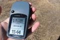
GPS proof
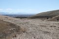
A rather limited but lovely view of town.

