Difference between revisions of "2013-04-03 43 -116"
imported>Eldin ([live] Coordinates reached. Will post details when I get home.) |
imported>FippeBot m (Location) |
||
| (3 intermediate revisions by one other user not shown) | |||
| Line 1: | Line 1: | ||
| − | |||
| − | |||
| − | |||
| − | |||
| − | |||
| − | |||
| − | |||
| − | |||
| − | |||
| − | |||
{{meetup graticule | {{meetup graticule | ||
| lat=43 | | lat=43 | ||
| Line 15: | Line 5: | ||
}} | }} | ||
| − | |||
__NOTOC__ | __NOTOC__ | ||
== Location == | == Location == | ||
| − | + | At the edge of a field, just off Sand Hollow Rd. | |
== Participants == | == Participants == | ||
| − | + | * [[User:Eldin | Eldin]] | |
| − | + | * Borneo | |
| − | |||
| − | |||
== Expedition == | == Expedition == | ||
| − | + | I'd had a run of bad luck with reaching coordinates lately, so when today's coordinates looked very reachable, I decided I had to go for it. I invited a friend who has expressed some interest in geohashing in the past to come with me. | |
| + | |||
| + | The expedition itself was unremarkable, as expeditions to easy coordinates often are. I picked up my friend at his house, we drove out and were able to park within 200ft of the coordinates, and it was an easy walk along the edge of a field with very young alfalfa growing in it to reach the hash. We had to walk right to the very edge of where the crop was growing to reach the point. Once there, we snapped a few pictures for proof, and then headed back into town to grab dinner. All in all it was a pleasant, if unspectacular, evening. | ||
*Coordinates reached. Will post details when I get home. -- [[User:Eldin|Eldin]] ([[User talk:Eldin|talk]]) [http://www.openstreetmap.org/?lat=43.90480367&lon=-116.77275103&zoom=16&layers=B000FTF @43.9048,-116.7728] 19:56, 3 April 2013 (MDT) | *Coordinates reached. Will post details when I get home. -- [[User:Eldin|Eldin]] ([[User talk:Eldin|talk]]) [http://www.openstreetmap.org/?lat=43.90480367&lon=-116.77275103&zoom=16&layers=B000FTF @43.9048,-116.7728] 19:56, 3 April 2013 (MDT) | ||
| − | |||
| − | |||
== Photos == | == Photos == | ||
| − | |||
| − | |||
| − | |||
<gallery perrow="5"> | <gallery perrow="5"> | ||
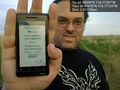
Image:2013-04-03_43_-116_19-51-13-196.jpg | Us at the coordinates. [http://www.openstreetmap.org/?lat=43.90439298&lon=-116.77280010&zoom=16&layers=B000FTF @43.9044,-116.7728] | Image:2013-04-03_43_-116_19-51-13-196.jpg | Us at the coordinates. [http://www.openstreetmap.org/?lat=43.90439298&lon=-116.77280010&zoom=16&layers=B000FTF @43.9044,-116.7728] | ||
| + | |||
| + | Image:2013-04-03_43_-116_20-02-28-773.jpg | Proof [http://www.openstreetmap.org/?lat=43.87470143&lon=-116.77124532&zoom=16&layers=B000FTF @43.8747,-116.7712] | ||
</gallery> | </gallery> | ||
== Achievements == | == Achievements == | ||
| − | {{ | + | {{land geohash |
| − | + | | latitude = 43 | |
| + | | longitude = -116 | ||
| + | | date = 2013-04-03 | ||
| + | | name = [[User:Eldin | Eldin]] and Borneo | ||
| + | }} | ||
| + | {{drag-along | ||
| + | | latitude = 43 | longitude = -116 | ||
| + | | date = 2013-04-03 | ||
| + | | partner = Borneo | ||
| + | | name = [[User:Eldin |Eldin ]] | ||
| + | }} | ||
| − | |||
| − | |||
| − | |||
| − | |||
| − | |||
| − | |||
| − | |||
| − | |||
| − | |||
| − | |||
[[Category:Expeditions]] | [[Category:Expeditions]] | ||
| − | |||
[[Category:Expeditions with photos]] | [[Category:Expeditions with photos]] | ||
| − | |||
| − | |||
| − | |||
| − | |||
| − | |||
[[Category:Coordinates reached]] | [[Category:Coordinates reached]] | ||
| − | + | {{location|US|ID|PA}} | |
| − | |||
| − | |||
| − | |||
| − | |||
| − | |||
| − | |||
| − | |||
| − | |||
| − | |||
| − | |||
| − | |||
| − | |||
| − | |||
| − | |||
| − | |||
| − | |||
| − | |||
Latest revision as of 01:44, 14 August 2019
| Wed 3 Apr 2013 in 43,-116: 43.9043891, -116.7728067 geohashing.info google osm bing/os kml crox |
Location
At the edge of a field, just off Sand Hollow Rd.
Participants
- Eldin
- Borneo
Expedition
I'd had a run of bad luck with reaching coordinates lately, so when today's coordinates looked very reachable, I decided I had to go for it. I invited a friend who has expressed some interest in geohashing in the past to come with me.
The expedition itself was unremarkable, as expeditions to easy coordinates often are. I picked up my friend at his house, we drove out and were able to park within 200ft of the coordinates, and it was an easy walk along the edge of a field with very young alfalfa growing in it to reach the hash. We had to walk right to the very edge of where the crop was growing to reach the point. Once there, we snapped a few pictures for proof, and then headed back into town to grab dinner. All in all it was a pleasant, if unspectacular, evening.
- Coordinates reached. Will post details when I get home. -- Eldin (talk) @43.9048,-116.7728 19:56, 3 April 2013 (MDT)
Photos

Us at the coordinates. @43.9044,-116.7728
Proof @43.8747,-116.7712


Achievements
Eldin and Borneo earned the Land geohash achievement
|
Eldin earned the Drag-along achievement
|