Difference between revisions of "2013-04-04 32 -117"
From Geohashing
imported>LucasBrown |
imported>FippeBot m (Location) |
||
| (One intermediate revision by one other user not shown) | |||
| Line 1: | Line 1: | ||
| − | + | {{meetup graticule | lat=32 | lon=-117 | date=2013-04-04}} | |
__NOTOC__ | __NOTOC__ | ||
| Line 17: | Line 17: | ||
[[Category:Expeditions with photos]] | [[Category:Expeditions with photos]] | ||
[[Category:Coordinates reached]] | [[Category:Coordinates reached]] | ||
| + | {{location|US|CA|SD}} | ||
Latest revision as of 01:44, 14 August 2019
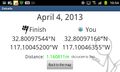
| Thu 4 Apr 2013 in 32,-117: 32.8009754, -117.1004520 geohashing.info google osm bing/os kml crox |
Location
Under an oak tree at the edge of the Admiral Baker golf course near Friars Road
Participants
Photos
Geohash Droid details page at the hashpoint
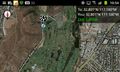
Map at the hashpoint

