Difference between revisions of "2013-04-21 55 37"
From Geohashing
imported>Vb (→Achievements) |
imported>FippeBot m (Location) |
||
| (One intermediate revision by one other user not shown) | |||
| Line 54: | Line 54: | ||
<!-- Add any achievement ribbons you earned below, or remove this section --> | <!-- Add any achievement ribbons you earned below, or remove this section --> | ||
| − | {{Walk geohash | latitude = 55 | longitude = 37 | date = 2013-04-21 | name = [[User:Vb|vb]] }} | + | {{Walk geohash | latitude = 55 | longitude = 37 | date = 2013-04-21 | name = [[User:Vb|vb]] | distance = 18.3km | image = 2013-04-21_55_37_track.jpg }} |
| Line 62: | Line 62: | ||
[[Category:Walk geohash achievement]] | [[Category:Walk geohash achievement]] | ||
[[Category:Land geohash achievement]] | [[Category:Land geohash achievement]] | ||
| + | {{location|RU|MOW}} | ||
Latest revision as of 01:59, 14 August 2019
| Sun 21 Apr 2013 in 55,37: 55.6455865, 37.3601992 geohashing.info google osm bing/os kml crox |
Location
In Choboty forest, Novo-Peredelkino district. Which is actually, despite being called a forest, is more like a park.
Participants
Plans
To walk, perhaps. Depends on the weather mostly.
Expedition
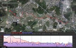
~18.3km walk, home - hash - some sightseeing - train station
Tracklog
Not completely, but mostly cleared from GPS glitches.
Photos
Achievements
vb earned the Walk geohash Achievement
|


