Difference between revisions of "2013-05-08 48 7"
imported>RecentlyChanged (Created page with "{{subst:Expedition | lat = 48 | lon = 7 | date = 2013-05-08 }}") |
imported>FippeBot m (Location) |
||
| (3 intermediate revisions by 2 users not shown) | |||
| Line 15: | Line 15: | ||
}} | }} | ||
| − | + | ||
__NOTOC__ | __NOTOC__ | ||
| − | |||
| − | |||
| − | |||
== Participants == | == Participants == | ||
| − | + | * [[User:RecentlyChanged|RecentlyChanged]] and a | |
| − | + | * friend of his who is new to geohashing. | |
| − | |||
| − | |||
| − | |||
== Expedition == | == Expedition == | ||
| − | + | We wanted to make a party in Freiburg. So we met in Offenburg: I took my car; he took the train. | |
| + | We came from almost opposite directions. | ||
| + | After a few problems with my PC (he distracted me), my car (something broke) and the traffic (he stood) I arrived about 45 minutes late, but he already bought something to read so he wasn't angry. After that we drove almost directly into 2 kilometers distance to the Hash, I already looked it up in GM. Then we entered the coordinates into the GPS device. My friend made his job very good and after just two wrong turns we found a good way. Good way in the sense of "It came near the Hash", I don't mean the quality of the way. There were deep mudholes and very high grass, I really was afraid to find a big stone in it, but it worked out well. Just my trunklid went open after a bigger stone, but it was more fun than danger. It's the second time now this happens while hashing, it only happens while hashing! | ||
| + | To get to the Hashpoint after our odyssey to the Hash was almost to easy, because it was not on a field but 30 meters away from the place I stopped my car, we took a few quick photos and went on to Freiburg. | ||
== Tracklog == | == Tracklog == | ||
| − | + | will come, but not very interesting | |
== Photos == | == Photos == | ||
| + | There are some ;) | ||
<!-- Insert pictures between the gallery tags using the following format: | <!-- Insert pictures between the gallery tags using the following format: | ||
Image:2012-##-## ## ## Alpha.jpg | Witty Comment | Image:2012-##-## ## ## Alpha.jpg | Witty Comment | ||
--> | --> | ||
<gallery perrow="5"> | <gallery perrow="5"> | ||
| + | Image:2013-05-08 48 7theproof.jpg|the proof | ||
| + | Image:2013-05-08 48 8 RC.jpg|Me looking for Hashpoint | ||
| + | Image:2013-05-08 48 8 formalattire.jpg| Proof for formal attire and drag along | ||
| + | |||
</gallery> | </gallery> | ||
== Achievements == | == Achievements == | ||
{{#vardefine:ribbonwidth|800px}} | {{#vardefine:ribbonwidth|800px}} | ||
| − | + | {{land geohash | latitude = 48 | longitude = 7 | date = 2013-05-08 | name = RecentlyChanged and another friend}} | |
| + | {{Formal attire | latitude = 48 | longitude = 7 | date = 2013-05-08 | name = friend of RC }} | ||
| + | {{drag-along | latitude = 48 | longitude = 7 | date = 2013-05-08 | name = RecentlyChanged}} {{Minesweeper geohash | ||
| + | |||
| + | | graticule = Pforzheim, Germany | ||
| + | | ranknumber = 2 | ||
| + | | n = true if graticule to the north has been hashed (optional) | ||
| + | | w = true | ||
| + | | name = RecentlyChanged | ||
| + | |||
| + | }} | ||
| − | |||
| − | |||
| − | |||
| − | |||
| − | |||
| − | |||
| − | |||
| − | |||
[[Category:Expeditions]] | [[Category:Expeditions]] | ||
| − | + | [[Category:Expeditions with photos]] | |
| − | [[Category:Expeditions with photos]] | ||
| − | |||
| − | |||
| − | |||
| − | |||
| − | |||
[[Category:Coordinates reached]] | [[Category:Coordinates reached]] | ||
| − | + | {{location|DE|BW|OG}} | |
| − | |||
| − | |||
| − | |||
| − | |||
| − | |||
| − | |||
| − | |||
| − | |||
| − | |||
| − | |||
| − | |||
| − | |||
| − | |||
| − | |||
| − | |||
| − | |||
| − | |||
Latest revision as of 02:14, 14 August 2019
| Wed 8 May 2013 in 48,7: 48.3755020, 7.8518256 geohashing.info google osm bing/os kml crox |
Participants
- RecentlyChanged and a
- friend of his who is new to geohashing.
Expedition
We wanted to make a party in Freiburg. So we met in Offenburg: I took my car; he took the train. We came from almost opposite directions. After a few problems with my PC (he distracted me), my car (something broke) and the traffic (he stood) I arrived about 45 minutes late, but he already bought something to read so he wasn't angry. After that we drove almost directly into 2 kilometers distance to the Hash, I already looked it up in GM. Then we entered the coordinates into the GPS device. My friend made his job very good and after just two wrong turns we found a good way. Good way in the sense of "It came near the Hash", I don't mean the quality of the way. There were deep mudholes and very high grass, I really was afraid to find a big stone in it, but it worked out well. Just my trunklid went open after a bigger stone, but it was more fun than danger. It's the second time now this happens while hashing, it only happens while hashing! To get to the Hashpoint after our odyssey to the Hash was almost to easy, because it was not on a field but 30 meters away from the place I stopped my car, we took a few quick photos and went on to Freiburg.
Tracklog
will come, but not very interesting
Photos
There are some ;)
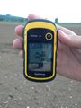
the proof
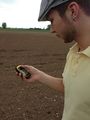
Me looking for Hashpoint
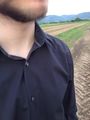
Proof for formal attire and drag along


Achievements
RecentlyChanged and another friend earned the Land geohash achievement
|
friend of RC earned the Formal attire achievement
|
RecentlyChanged earned the Drag-along achievement
|
RecentlyChanged achieved level 2 of the Minesweeper Geohash achievement
|