Difference between revisions of "2013-05-12 51 -0"
imported>Jondclarke |
imported>FippeBot m (Location) |
||
| (12 intermediate revisions by 2 users not shown) | |||
| Line 4: | Line 4: | ||
| date=2013-05-12 | | date=2013-05-12 | ||
}} | }} | ||
| − | |||
| − | |||
| − | |||
== Location == | == Location == | ||
| Line 16: | Line 13: | ||
== Participants == | == Participants == | ||
| − | |||
*[[User:PaintedJaguar|PainterJaguar]] | *[[User:PaintedJaguar|PainterJaguar]] | ||
*MrsPaintedJaguar | *MrsPaintedJaguar | ||
== Plans == | == Plans == | ||
| − | [[User: | + | [[User:PaintedJaguar|PaintedJaguar]] intends to catch the 10:51 train from Cambridge to Waltham Cross, and then walk to the hashpoint, arriving at around 12:30 (just missing Jondclarke, but maybe finding some kind of marker that he might leave behind from the earlier expedition?). MrsPaintedJaguar's desire to explore the Lee Valley area, rather than the M25, means that the double hash with the neighbouring graticule probably won't be possible. |
| − | + | == Expedition == | |
| − | + | === PaintedJaguar and MrsPaintedJaguar === | |
| − | + | Oh, the joys of public transport :-) | |
| − | + | We arrived at Cambridge station in good time to catch the 10:51 train, as planned. However, the departure boards were showing the 10:51 train as only going as far as Bishop's Stortford due to overrunning engineering works (for those who don't know the Cambridge to London train lines like the back of their hand, Bishop's Stortford is about half-way between Cambridge and our intended destination of Waltham Cross). We were, however, assured that there would be a rail replacement bus service from Bishop's Stortford, so got on the train as planned. | |
| − | + | Upon arrival at Bishop's Stortford, we were directed to the bus, only to be told that the bus was only going as far as Cheshunt (one stop before Waltham Cross), and there'd be another train from Cheshunt. Comically the bus turned out to be an everyday bus that is normally used for short journeys within a city, rather than a proper coach, and there were a number of times when we weren't sure it was going to survive being driven at high speed down major trunk roads. But fortunately it did survive, and for good measure it even took us along a road that we had walked down in our [[2013-02-03_51_0|previous geohash in Sawbridgeworth]], past a pub where we'd enjoyed a very nice Sunday lunch. | |
| − | + | Eventually we made it to Cheshunt, now an hour later than our intended arrival time at Waltham Cross. But the next train to Waltham Cross was shown as delayed by 20 minutes, and when we saw that other trains were still being cancelled at the last minute due to the still problematic engineering works, we decided to change our plans. Cheshunt is still adjacent to the Lee Valley, which we'd intended to explore after reaching the geohash, so we checked our maps to verify that we had printed out enough of the area to include Cheshunt, and plotted a walking route from Cheshunt to Waltham Cross, with a plan to reach the hashpoint at the end of the day. | |
| − | |||
| − | |||
| − | + | So we set off in glorious sunshine, exploring the Lee Valley, and after not long found ourselves in Lee Valley Park Farm, which had a collection of rather cute animals, and also, somewhat inappropriately we felt, a collection of turkeys whose "home" had been decorated to look like a Christmas scene! Having eventually persuaded MrsPaintedJaguar that we couldn't take a meerkat or a rabbit home with us, we set about the main walk to the hashpoint. The sky had clouded over and the wind had picked up, which suggested that rain wasn't too far away, and sure enough the drizzle started not long after we left the farm. The path followed a river where we saw a number of grebes and coots, as well as the more common ducks, swans and geese. We soon reached the last point where we could sensibly abandon the trip and head back to Cheshunt station instead of pressing on to Waltham Cross, but decided that as the rain wasn't too bad, we should press on. | |
| − | + | This, of course, was the perfect cue for the rain to get heavier, which it duly did. But we carried on, eventually passing under the M25 motorway that signified the hashpoint was close, and that we needed to leave the proper path by the river and head into the nearby shrubland. There was a well-trodden path through the shrubs, but we were a bit concerned by the height of some of them - the impression from Google Maps had been that this was just a grassy area, rather than brambles and nettles. Eventually we got to a point 50m from the hashpoint where the path no longer continued in the right direction, and we had to fight our way through the brambles. This wasn't as bad as we'd initially thought - but I was glad to be wearing long trousers and not shorts! | |
| − | + | Getting to the exact hashpoint wasn't too bad, and the GPS didn't misbehave at all, directing us pretty much straight to right point, easily within its accuracy level. The brambles near the hashpoint did look a little bit like they'd already been flattened, perhaps suggesting jondclarke had been here earlier in the day, but to be honest it was impossible to be sure if someone else had been there or not. There was a small bush nearby with an easily accessible trunk, so I chalked a geohashing maker to the trunk. Then, despite the weather and less-than-comfortable ground, we got out the picnic rug and ate some of our provisions, although it was probably the quickest picnic I've ever had! | |
| − | + | After packing up again, we headed back to the river and back under the M25, before turning away from the river to head into Waltham Cross. On arriving at the train station we saw that the trains were now running to time, but we had to wait either 30 or 90 minutes for a scheduled train back to Cambridge. We decided to head into the centre of Waltham Cross to find a pub, but after 10-15 minutes of wandering around a town centre where absolutely everything appeared to be closed, and no pub in sight, we headed back to the station to get the first train home. | |
| − | |||
| − | + | == Photos == | |
| + | === PaintedJaguar and MrsPaintedJaguar === | ||
| + | <gallery perrow="5"> | ||
| + | Image:2013-05-12_51_-0_turkey_christmas_coop_DSC05788.JPG|Inappropriately housed turkeys | ||
| + | Image:2013-05-12_51_-0_meerkat.JPG|Meerkat | ||
| + | Image:2013-05-12_51_-0_rabbit2.JPG|Rabbit | ||
| + | Image:2013-05-12_51_-0_rabbit1.JPG|Rabbit nibbling at MrsPaintedJaguar's foot | ||
| + | Image:2013-05-12_51_-0_tractor_sign.JPG|The thought hadn't crossed my mind until I saw the sign... | ||
| + | Image:2013-05-12_51_-0_river.JPG|River in Lee Valley Park | ||
| + | Image:2013-05-12_51_-0_approaching_M25.JPG|Approaching the M25 | ||
| + | Image:2013-05-12_51_-0_under_M25.JPG|Going under the M25 | ||
| + | Image:2013-05-12_51_-0_M25.JPG|View of M25 from near the hashpoint | ||
| + | Image:2013-05-12_51_-0_hashpoint.JPG|View from the hashpoint | ||
| + | Image:2013-05-12_51_-0_gps.JPG|GPS coordinates at the hashpoint | ||
| + | Image:2013-05-12_51_-0_grin.JPG|Silly grin | ||
| + | Image:2013-05-12_51_-0_picnic.JPG|Picnic in the rain, with Hammersmith the hashscot | ||
| + | Image:2013-05-12_51_-0_picnic2.JPG|Picnic in the rain | ||
| + | Image:2013-05-12_51_-0_marker.JPG|XKCD marker written onto a nearby tree | ||
| + | Image:2013-05-12_51_-0_train_tickets.JPG|Proof of public transport geohash | ||
| + | </gallery> | ||
| − | + | == Tracklog == | |
| − | + | http://en.wikiloc.com/wikiloc/view.do?id=4622932 shows PaintedJaguar's walk from Chesunt station, through Lee Valley to the hashpoint, and bac k to Waltham Cross station. | |
| − | + | == Achievements == | |
| + | {{#vardefine:ribbonwidth|800px}} | ||
| − | + | {{land geohash | |
| + | | latitude = 51 | ||
| + | | longitude = -0 | ||
| + | | date = 2013-05-12 | ||
| + | | name = PaintedJaguar | ||
| + | }} | ||
| − | + | {{Public transport geohash | |
| + | | latitude = 51 | ||
| + | | longitude = -0 | ||
| + | | date = 2013-05-12 | ||
| + | | busline = the significantly delayed train and rail-replacement bus | ||
| + | | name = PaintedJaguar | ||
| + | | image = 2013-05-12_51_-0_train_tickets.JPG | ||
| + | }} | ||
| − | + | {{Picnic_geohash | |
| + | | latitude = 51 | ||
| + | | longitude = -0 | ||
| + | | date = 2013-05-12 | ||
| + | | name = PaintedJaguar | ||
| + | | food = couscous salad, cherry tomatoes and hard-boiled eggs | ||
| + | | image = 2013-05-12_51_-0_picnic.JPG | ||
| + | }} | ||
| − | + | {{Drowned rat geohash | |
| − | + | | latitude = 51 | |
| − | + | | longitude = -0 | |
| − | + | | date = 2013-05-12 | |
| − | + | | name = PaintedJaguar | |
| − | + | | reason = persistent steady rain | |
| − | + | | honourable = yes | |
| − | + | }} | |
| − | |||
| − | |||
| − | |||
| − | |||
| − | |||
| − | |||
| − | |||
| − | |||
| − | |||
| − | |||
| − | + | [[Category:Expeditions]] | |
| − | [[Category:Expedition | + | [[Category:Expeditions with photos]] |
| + | [[Category:Expedition without GPS]] | ||
| + | [[Category:Coordinates reached]] | ||
| + | {{location|GB|ENG|ENF}} | ||
Latest revision as of 05:55, 6 August 2019
| Sun 12 May 2013 in 51,-0: 51.6778850, -0.0141189 geohashing.info google osm bing/os kml crox |
Contents
Location
A green space near the River Lee navigation and cycleway in Enfield.
On Google Street View [1], looks like this is a public park called Ramney Marsh, but I can't find any reference to rights of way, etc. in either Ordnance Survey or OpenStreetMap. Oh well, I'll just go for it! I should be able to reach S Ordnance Road, follow the footpath by the channel for 200m, then enter the green space heading WNW then N. Hopefully I'll be able to see the footbridge through the trees, bearing 085, and the junction of paths, bearing 180.
It's also within a few hundred metres (as the crow flies...) of the neighbouring graticule's hashpoint 2013-05-12 51 0. Of course, I'm not a crow, and there are the small problems of a river, a side-channel, several hedges and the M25 motorway in between... As Huinesoron said, "Gotta love that Prime Meridian!"
Participants
- PainterJaguar
- MrsPaintedJaguar
Plans
PaintedJaguar intends to catch the 10:51 train from Cambridge to Waltham Cross, and then walk to the hashpoint, arriving at around 12:30 (just missing Jondclarke, but maybe finding some kind of marker that he might leave behind from the earlier expedition?). MrsPaintedJaguar's desire to explore the Lee Valley area, rather than the M25, means that the double hash with the neighbouring graticule probably won't be possible.
Expedition
PaintedJaguar and MrsPaintedJaguar
Oh, the joys of public transport :-)
We arrived at Cambridge station in good time to catch the 10:51 train, as planned. However, the departure boards were showing the 10:51 train as only going as far as Bishop's Stortford due to overrunning engineering works (for those who don't know the Cambridge to London train lines like the back of their hand, Bishop's Stortford is about half-way between Cambridge and our intended destination of Waltham Cross). We were, however, assured that there would be a rail replacement bus service from Bishop's Stortford, so got on the train as planned.
Upon arrival at Bishop's Stortford, we were directed to the bus, only to be told that the bus was only going as far as Cheshunt (one stop before Waltham Cross), and there'd be another train from Cheshunt. Comically the bus turned out to be an everyday bus that is normally used for short journeys within a city, rather than a proper coach, and there were a number of times when we weren't sure it was going to survive being driven at high speed down major trunk roads. But fortunately it did survive, and for good measure it even took us along a road that we had walked down in our previous geohash in Sawbridgeworth, past a pub where we'd enjoyed a very nice Sunday lunch.
Eventually we made it to Cheshunt, now an hour later than our intended arrival time at Waltham Cross. But the next train to Waltham Cross was shown as delayed by 20 minutes, and when we saw that other trains were still being cancelled at the last minute due to the still problematic engineering works, we decided to change our plans. Cheshunt is still adjacent to the Lee Valley, which we'd intended to explore after reaching the geohash, so we checked our maps to verify that we had printed out enough of the area to include Cheshunt, and plotted a walking route from Cheshunt to Waltham Cross, with a plan to reach the hashpoint at the end of the day.
So we set off in glorious sunshine, exploring the Lee Valley, and after not long found ourselves in Lee Valley Park Farm, which had a collection of rather cute animals, and also, somewhat inappropriately we felt, a collection of turkeys whose "home" had been decorated to look like a Christmas scene! Having eventually persuaded MrsPaintedJaguar that we couldn't take a meerkat or a rabbit home with us, we set about the main walk to the hashpoint. The sky had clouded over and the wind had picked up, which suggested that rain wasn't too far away, and sure enough the drizzle started not long after we left the farm. The path followed a river where we saw a number of grebes and coots, as well as the more common ducks, swans and geese. We soon reached the last point where we could sensibly abandon the trip and head back to Cheshunt station instead of pressing on to Waltham Cross, but decided that as the rain wasn't too bad, we should press on.
This, of course, was the perfect cue for the rain to get heavier, which it duly did. But we carried on, eventually passing under the M25 motorway that signified the hashpoint was close, and that we needed to leave the proper path by the river and head into the nearby shrubland. There was a well-trodden path through the shrubs, but we were a bit concerned by the height of some of them - the impression from Google Maps had been that this was just a grassy area, rather than brambles and nettles. Eventually we got to a point 50m from the hashpoint where the path no longer continued in the right direction, and we had to fight our way through the brambles. This wasn't as bad as we'd initially thought - but I was glad to be wearing long trousers and not shorts!
Getting to the exact hashpoint wasn't too bad, and the GPS didn't misbehave at all, directing us pretty much straight to right point, easily within its accuracy level. The brambles near the hashpoint did look a little bit like they'd already been flattened, perhaps suggesting jondclarke had been here earlier in the day, but to be honest it was impossible to be sure if someone else had been there or not. There was a small bush nearby with an easily accessible trunk, so I chalked a geohashing maker to the trunk. Then, despite the weather and less-than-comfortable ground, we got out the picnic rug and ate some of our provisions, although it was probably the quickest picnic I've ever had!
After packing up again, we headed back to the river and back under the M25, before turning away from the river to head into Waltham Cross. On arriving at the train station we saw that the trains were now running to time, but we had to wait either 30 or 90 minutes for a scheduled train back to Cambridge. We decided to head into the centre of Waltham Cross to find a pub, but after 10-15 minutes of wandering around a town centre where absolutely everything appeared to be closed, and no pub in sight, we headed back to the station to get the first train home.
Photos
PaintedJaguar and MrsPaintedJaguar

Inappropriately housed turkeys
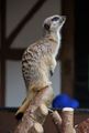
Meerkat
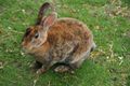
Rabbit
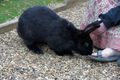
Rabbit nibbling at MrsPaintedJaguar's foot
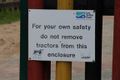
The thought hadn't crossed my mind until I saw the sign...
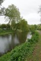
River in Lee Valley Park
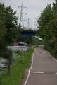
Approaching the M25
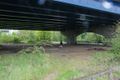
Going under the M25
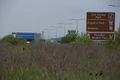
View of M25 from near the hashpoint
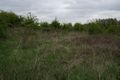
View from the hashpoint
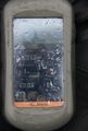
GPS coordinates at the hashpoint

Silly grin
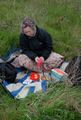
Picnic in the rain, with Hammersmith the hashscot
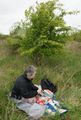
Picnic in the rain
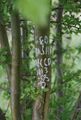
XKCD marker written onto a nearby tree
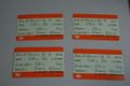
Proof of public transport geohash


Tracklog
http://en.wikiloc.com/wikiloc/view.do?id=4622932 shows PaintedJaguar's walk from Chesunt station, through Lee Valley to the hashpoint, and bac k to Waltham Cross station.
Achievements
PaintedJaguar earned the Land geohash achievement
|
PaintedJaguar earned the Public transport geohash achievement
|
PaintedJaguar earned the Picnic achievement
|
PaintedJaguar earned the Drowned Rat Geohash Honourable Mention
|