Difference between revisions of "2013-05-15 43 -116"
imported>Eldin ([live] At the hashpoint now. Easy one today) |
imported>FippeBot m (Location) |
||
| (10 intermediate revisions by one other user not shown) | |||
| Line 1: | Line 1: | ||
| − | |||
| − | |||
| − | |||
| − | |||
| − | |||
| − | |||
| − | |||
| − | |||
| − | |||
| − | |||
{{meetup graticule | {{meetup graticule | ||
| lat=43 | | lat=43 | ||
| Line 15: | Line 5: | ||
}} | }} | ||
| − | |||
__NOTOC__ | __NOTOC__ | ||
== Location == | == Location == | ||
| − | + | ||
| + | Behind the Walgreens at Horseshoe Bend Rd. and State St. in Eagle, ID. | ||
== Participants == | == Participants == | ||
| − | + | ||
| − | + | * [[User:Eldin|Eldin]] | |
== Plans == | == Plans == | ||
| − | + | ||
| + | Visit the hash because it was too easy to pass up. | ||
== Expedition == | == Expedition == | ||
| − | + | I drove to the hash. I left a poster. I took pictures. Not a terribly exciting expedition. In retrospect, I probably should have bicycled to this one. But I got a later start than I'd hoped due to work, and the route there isn't terribly bicycle friendly. | |
| + | *At the hashpoint now. Easy one today -- [[User:Eldin|Eldin]] ([[User talk:Eldin|talk]]) [http://www.openstreetmap.org/?lat=43.68105493&lon=-116.31242572&zoom=16&layers=B000FTF @43.6811,-116.3124] 18:43, 15 May 2013 (MDT) | ||
| − | + | '''NOTE:''' It has been pointed out to me that the photos uploaded via the Geohash Droid app show a distance of over 400ft from the hash. I can not account for why they show this, but please see the 'proof' picture for the coordinates I was seeing when I was there. And based on both OSM maps and Google Satelite imagery, combined with what I saw while I was there, I am highly confident that the coordinates displayed on my phone's screen are accurate, while the coordinates displayed on the photos are not. | |
| − | |||
| − | |||
== Photos == | == Photos == | ||
| − | |||
| − | |||
| − | |||
<gallery perrow="5"> | <gallery perrow="5"> | ||
| − | |||
| − | == | + | Image:2013-05-15_43_-116_18-44-18-962.jpg | Grin [http://www.openstreetmap.org/?lat=43.68030000&lon=-116.31100000&zoom=16&layers=B000FTF @43.6803,-116.3110] |
| − | + | ||
| − | + | Image:2013-05-15_43_-116_18-45-10-611.jpg | Marker | |
| + | Image:2013-05-15_43_-116_18-45-37-084.jpg | Hashpoint | ||
| − | + | Image:2013-05-15_43_-116_18-46-33-880.jpg | Walgreens to the west. | |
| − | |||
| − | |||
| − | + | Image:2013-05-15_43_-116_18-47-16-402.jpg | Clinic to the south. | |
| − | |||
| − | |||
| − | |||
| − | + | Image:2013-05-15_43_-116_18-48-24-030.jpg | Sign to the east. This hash point is for sale. | |
| − | |||
| − | |||
| − | |||
| − | |||
| − | |||
| − | -- | ||
| − | |||
| − | |||
| − | |||
| + | Image:2013-05-15_43_-116_18-49-07-976.jpg | Houses and trees to the north. | ||
| − | + | Image:2013-05-15 43 -116 proof.jpg | Proof of reaching the coordinates. | |
| − | + | </gallery> | |
| − | |||
| − | |||
| − | |||
| − | |||
| − | |||
| − | |||
| − | + | == Achievements == | |
| − | + | {{#vardefine:ribbonwidth|800px}} | |
| − | + | {{land geohash | |
| − | + | | latitude = 43 | |
| − | [[ | + | | longitude = -116 |
| + | | date = 2013-05-15 | ||
| + | | name = [[User:Eldin|Eldin]] | ||
| + | }} | ||
| − | + | [[Category:Expeditions]] | |
| + | [[Category:Expeditions with photos]] | ||
| + | [[Category:Coordinates reached]] | ||
| + | {{location|US|ID|AA}} | ||
Latest revision as of 02:20, 14 August 2019
| Wed 15 May 2013 in 43,-116: 43.6810543, -116.3124297 geohashing.info google osm bing/os kml crox |
Location
Behind the Walgreens at Horseshoe Bend Rd. and State St. in Eagle, ID.
Participants
Plans
Visit the hash because it was too easy to pass up.
Expedition
I drove to the hash. I left a poster. I took pictures. Not a terribly exciting expedition. In retrospect, I probably should have bicycled to this one. But I got a later start than I'd hoped due to work, and the route there isn't terribly bicycle friendly.
- At the hashpoint now. Easy one today -- Eldin (talk) @43.6811,-116.3124 18:43, 15 May 2013 (MDT)
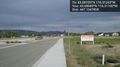
NOTE: It has been pointed out to me that the photos uploaded via the Geohash Droid app show a distance of over 400ft from the hash. I can not account for why they show this, but please see the 'proof' picture for the coordinates I was seeing when I was there. And based on both OSM maps and Google Satelite imagery, combined with what I saw while I was there, I am highly confident that the coordinates displayed on my phone's screen are accurate, while the coordinates displayed on the photos are not.
Photos

Grin @43.6803,-116.3110
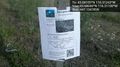
Marker
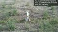
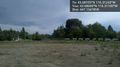
Hashpoint
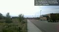
Walgreens to the west.

Clinic to the south.
Sign to the east. This hash point is for sale.
Houses and trees to the north.
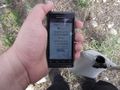
Proof of reaching the coordinates.


Achievements
Eldin earned the Land geohash achievement
|