Difference between revisions of "2013-05-09 53 8"
imported>Oliver (Created page with "{{subst:Expedition |lat = 53 |lon = 8 |date = 2013-05-09 }}") |
imported>FippeBot m (Location) |
||
| (4 intermediate revisions by 3 users not shown) | |||
| Line 1: | Line 1: | ||
| − | |||
| − | |||
| − | |||
| − | |||
| − | |||
| − | |||
| − | |||
| − | |||
| − | |||
{{meetup graticule | {{meetup graticule | ||
| lat=53 | | lat=53 | ||
| Line 15: | Line 6: | ||
}} | }} | ||
| − | |||
__NOTOC__ | __NOTOC__ | ||
== Location == | == Location == | ||
| − | + | Todays hash was located near the city of Bremen, on the shore of small Wümme river. | |
== Participants == | == Participants == | ||
| − | + | [[User:Oliver|Oliver]] | |
| − | |||
== Plans == | == Plans == | ||
| − | + | This was a perfect day and occurence to start geohashing in Bremen: holiday due to Ascension Day (in Germany this is also Fathers' Day), perfect weather, and a geohash within 12km from home in beautiful landscape. The bike was finally in perfect condition, so everything screamed to go on a cycle tour to the norther outskirts of the city. Other geohashers are rare in this region, but the arrival was planned for the usual meetup time of 16:00h anyway. | |
== Expedition == | == Expedition == | ||
| − | + | With everything prepared (or so was hoped), I left home at around 15:00h and leisurely cycled through Bremen. There's a great route going through Bürgerpark and then through the extensive allotment areas to the north, then crossing the Blockland area and finally leading along the southern shore of Wümme river. This being Fathers' Day, Bürgerpark and the meadowy Blockland area was crowded with people enjoying the nice weather and a cold beer. | |
| + | |||
| + | Reaching the point of the river where the geohash was located I found my worst fears confirmed: the spot was decidedly in the watery part of the shore, and what was supposed to be the non-watery part of the shore was actually a flooded swamp. Exploring the landscape or the map from all sides was interesting but not fruitful. Attempts to hire a boat at the nearby mooring were met with failure. It now turned out that preparation had missed critical pieces of equipment: towel (''oh how could he!'') and swimming trunks. | ||
| − | + | So, separated from the desired spot by several ten meters of river, I gave up on this geohash and returned, taking the cycleway through Gröpelingen and along Werdersee which turned this into a nice cycling trip all in all. | |
| − | |||
== Photos == | == Photos == | ||
| − | |||
| − | |||
| − | |||
<gallery perrow="5"> | <gallery perrow="5"> | ||
| + | Image:Geohash-2013-05-13-grat-53-8-bremen-1s.jpg | From southern shore - looks nice | ||
| + | Image:Geohash-2013-05-13-grat-53-8-bremen-2s.jpg | From northern shore - looks not so nice | ||
| + | Image:Geohash-2013-05-13-grat-53-8-bremen-3s.jpg | ||
</gallery> | </gallery> | ||
== Achievements == | == Achievements == | ||
| − | + | ||
| − | + | * MNB? | |
| + | * Kingdom for my boat? | ||
<!-- =============== USEFUL CATEGORIES FOLLOW ================ | <!-- =============== USEFUL CATEGORIES FOLLOW ================ | ||
Delete the next line ONLY if you have chosen the appropriate categories below. If you are unsure, don't worry. People will read your report and help you with the classification. --> | Delete the next line ONLY if you have chosen the appropriate categories below. If you are unsure, don't worry. People will read your report and help you with the classification. --> | ||
| − | [[Category: | + | [[Category:Expeditions]] |
| − | |||
| − | |||
| − | |||
| − | |||
| − | |||
| − | |||
| − | |||
| − | |||
[[Category:Expeditions with photos]] | [[Category:Expeditions with photos]] | ||
| − | |||
| − | |||
| − | |||
| − | |||
| − | |||
| − | |||
| − | |||
[[Category:Coordinates not reached]] | [[Category:Coordinates not reached]] | ||
| − | + | ||
| − | |||
[[Category:Not reached - Mother Nature]] | [[Category:Not reached - Mother Nature]] | ||
| − | + | {{location|DE|NI|OHZ}} | |
| − | |||
| − | |||
| − | |||
| − | |||
| − | |||
| − | |||
| − | |||
| − | |||
| − | |||
| − | |||
Latest revision as of 02:15, 14 August 2019
| Thu 9 May 2013 in 53,8: 53.1637194, 8.7544208 geohashing.info google osm bing/os kml crox |
Location
Todays hash was located near the city of Bremen, on the shore of small Wümme river.
Participants
Plans
This was a perfect day and occurence to start geohashing in Bremen: holiday due to Ascension Day (in Germany this is also Fathers' Day), perfect weather, and a geohash within 12km from home in beautiful landscape. The bike was finally in perfect condition, so everything screamed to go on a cycle tour to the norther outskirts of the city. Other geohashers are rare in this region, but the arrival was planned for the usual meetup time of 16:00h anyway.
Expedition
With everything prepared (or so was hoped), I left home at around 15:00h and leisurely cycled through Bremen. There's a great route going through Bürgerpark and then through the extensive allotment areas to the north, then crossing the Blockland area and finally leading along the southern shore of Wümme river. This being Fathers' Day, Bürgerpark and the meadowy Blockland area was crowded with people enjoying the nice weather and a cold beer.
Reaching the point of the river where the geohash was located I found my worst fears confirmed: the spot was decidedly in the watery part of the shore, and what was supposed to be the non-watery part of the shore was actually a flooded swamp. Exploring the landscape or the map from all sides was interesting but not fruitful. Attempts to hire a boat at the nearby mooring were met with failure. It now turned out that preparation had missed critical pieces of equipment: towel (oh how could he!) and swimming trunks.
So, separated from the desired spot by several ten meters of river, I gave up on this geohash and returned, taking the cycleway through Gröpelingen and along Werdersee which turned this into a nice cycling trip all in all.
Photos
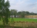
From southern shore - looks nice
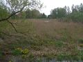
From northern shore - looks not so nice


Achievements
- MNB?
- Kingdom for my boat?