Difference between revisions of "2013-05-19 53 8"
imported>Oliver |
imported>Oliver |
||
| Line 1: | Line 1: | ||
| − | |||
| − | |||
| − | |||
| − | |||
| − | |||
| − | |||
| − | |||
| − | |||
| − | |||
{{meetup graticule | {{meetup graticule | ||
| lat=53 | | lat=53 | ||
| Line 21: | Line 12: | ||
== Participants == | == Participants == | ||
| − | |||
| − | |||
[[User:Oliver|Oliver]] | [[User:Oliver|Oliver]] | ||
== Plans == | == Plans == | ||
| − | |||
Planning to do a bicycle tour there. | Planning to do a bicycle tour there. | ||
| Line 37: | Line 25: | ||
== Photos == | == Photos == | ||
| − | |||
| − | |||
| − | |||
<gallery perrow="5"> | <gallery perrow="5"> | ||
| + | Image:Geohash-2013-05-19-grat-53-8-seehausen-1s.jpg | Time for a "field" trip | ||
| + | Image:Geohash-2013-05-19-grat-53-8-seehausen-2s.jpg | Made it! | ||
| + | Image:Geohash-2013-05-19-grat-53-8-seehausen-3s.jpg | Wonder how long permanent marker will endure in these conditions? | ||
| + | Image:Geohash-2013-05-19-grat-53-8-seehausen-4s.jpg | Crossing the swamp; in the background the furnaces of <strike>Mordor</strike> [http://de.wikipedia.org/wiki/ArcelorMittal_Bremen Bremen steel works] | ||
</gallery> | </gallery> | ||
| Line 47: | Line 36: | ||
<!-- Add any achievement ribbons you earned below, or remove this section --> | <!-- Add any achievement ribbons you earned below, or remove this section --> | ||
| − | |||
| − | |||
| − | |||
| − | |||
| − | |||
| − | |||
| − | |||
| − | |||
| − | |||
| − | |||
| − | |||
[[Category:Expeditions]] | [[Category:Expeditions]] | ||
| − | |||
[[Category:Expeditions with photos]] | [[Category:Expeditions with photos]] | ||
| − | |||
| − | |||
| − | |||
| − | |||
| − | |||
[[Category:Coordinates reached]] | [[Category:Coordinates reached]] | ||
| − | |||
| − | |||
| − | |||
| − | |||
| − | |||
| − | |||
| − | |||
| − | |||
| − | |||
| − | |||
| − | |||
| − | |||
| − | |||
| − | |||
| − | |||
| − | |||
| − | |||
| − | |||
Revision as of 22:19, 19 May 2013
| Sun 19 May 2013 in 53,8: 53.1036379, 8.6840838 geohashing.info google osm bing/os kml crox |
Location
In the meadows near Seehausen/Bremen.
Participants
Plans
Planning to do a bicycle tour there.
Expedition
With weather being nicer than yesterday (no rain at least), I started cycling towards Seehausen around at 15:00h. The geohash was near the Weserradweg, a national cycling route along Weser river; as result, the largest part of my tour went over excellent cycleways and through quite nice areas. Hence I easily reached the junction on the main road from where a country road led through the fields.
Google Maps had shown that the geohash was somewhere in the fields which were divided by ditches; so now I looked for the correct field to enter - hoping it wouldn't be one of those with cows on it. Finally picked one field which was cow-free and hopefully at the right location. Being lazy, I decided that cycling is better than walking, lifted the bike over the gate, and rode on through the grass. There was a high seat visible in the distance, probably quite close to the geohash; so I was pretty confident that the spot was reachable. However, whatever hunter used to go there probably wore knee-high rubber boots to get through the swamp that cut the field in half. For me, that meant some jumping, and a shoe full of water; and all the while the angry chirping of lots of birds - probably nesting in the vast swampy meadows.
Getting closer to the geohash, it turned out that I had indeed chosen the wrong field. Fortunately there was a ditch crossing at the high seat. So after climbing another fence and yet another gate and walking through the field for 10 minutes (trying to hit the coordinates without treading into one the many infernally hidden mini-ditches), I finally made it! As the spot was right on the grass, I decided not to leave any paper marker, and instead wrote a note on a fencepost at the high seat. Made my way back over the gate, through the swamp and over the other gate, and off. I guess the birds were happy to finally be rid of me.
Photos
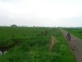
Time for a "field" trip
Made it!
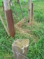
Wonder how long permanent marker will endure in these conditions?
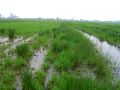
Crossing the swamp; in the background the furnaces of
MordorBremen steel works


