Difference between revisions of "2013-05-26 53 8"
imported>Oliver |
imported>FippeBot m (Location) |
||
| (One intermediate revision by one other user not shown) | |||
| Line 1: | Line 1: | ||
| − | |||
| − | |||
| − | |||
| − | |||
| − | |||
| − | |||
| − | |||
| − | |||
| − | |||
{{meetup graticule | {{meetup graticule | ||
| lat=53 | | lat=53 | ||
| Line 15: | Line 6: | ||
}} | }} | ||
| − | |||
__NOTOC__ | __NOTOC__ | ||
== Location == | == Location == | ||
| − | |||
In the wetlands at Wümme river, near Bremen. | In the wetlands at Wümme river, near Bremen. | ||
== Participants == | == Participants == | ||
| − | |||
| − | |||
[[User:Oliver|Oliver]] | [[User:Oliver|Oliver]] | ||
== Plans == | == Plans == | ||
| − | |||
It's close to Bremen, so I'll do a bicycle tour there. Not sure if the geohash itself is reachable (according to [http://www.openstreetmap.org/?mlat=53.11459057&mlon=8.96006199&zoom=15 OSM] it's a swamp). | It's close to Bremen, so I'll do a bicycle tour there. Not sure if the geohash itself is reachable (according to [http://www.openstreetmap.org/?mlat=53.11459057&mlon=8.96006199&zoom=15 OSM] it's a swamp). | ||
== Expedition == | == Expedition == | ||
| − | |||
Well, it's no swamp, it's wetlands; which doesn't make it much better. | Well, it's no swamp, it's wetlands; which doesn't make it much better. | ||
| Line 39: | Line 24: | ||
== Photos == | == Photos == | ||
| − | |||
| − | |||
| − | |||
<gallery perrow="5"> | <gallery perrow="5"> | ||
| + | Image:Geohash-2013-05-26-grat-53-8-bremen-3s.jpg | The Wümme | ||
| + | Image:Geohash-2013-05-26-grat-53-8-bremen-1s.jpg | Into the wild blue-green yonder | ||
| + | Image:Geohash-2013-05-26-grat-53-8-bremen-2s.jpg | End of the line... | ||
</gallery> | </gallery> | ||
| − | |||
| − | |||
| − | |||
| − | |||
[[Category:Expeditions]] | [[Category:Expeditions]] | ||
[[Category:Coordinates not reached]] | [[Category:Coordinates not reached]] | ||
[[Category:Not reached - Mother Nature]] | [[Category:Not reached - Mother Nature]] | ||
| + | {{location|DE|NI|VER}} | ||
Latest revision as of 02:34, 14 August 2019
| Sun 26 May 2013 in 53,8: 53.1145906, 8.9600620 geohashing.info google osm bing/os kml crox |
Location
In the wetlands at Wümme river, near Bremen.
Participants
Plans
It's close to Bremen, so I'll do a bicycle tour there. Not sure if the geohash itself is reachable (according to OSM it's a swamp).
Expedition
Well, it's no swamp, it's wetlands; which doesn't make it much better.
The cycling tour itself was uneventful but rainy, and I quickly reached a point shortly behind Wümme bridge where I left the bike and continued by foot. As promised by OSM there was a path leading into the fields, which I followed to its end. From there I was able to go on by walking through the field, checking at each step whether the ground was sufficiently solid. There was still hope to reach the geohash this way - but only for maybe 50 meters. Finally, a ditch in the flooded field made clear that this territory belonged to the water rather than the land. Seeking for a crossing I walked along the ditch for some ten meters, but was blocked by the water joining from the field itself. A boat wouldn't have helped either; but maybe rubber boots, wooden planks, a tractor or a horse would have been successful here. Having brought neither of these, I finally gave up and went back to the bike.
Trying to enter the fields from another place up the road wasn't any more successful, so I turned around and drove home. Interestingly, the road where I left my bike is part of the D7 national cycling route on its way from Hamburg to Bremen, so at least I could enjoy excellent cycle ways on my way back home.
Photos
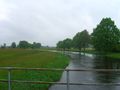
The Wümme
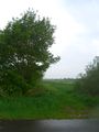
Into the wild blue-green yonder
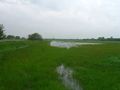
End of the line...


