Difference between revisions of "2013-05-26 64 27"
From Geohashing
imported>Pastori (Pastori achieves triple hash and minesweeper level 4!) |
imported>FippeBot m (Location) |
||
| (4 intermediate revisions by 2 users not shown) | |||
| Line 20: | Line 20: | ||
This hashpoint was within the municipality of Sotkamo, near the road to Pöppölä. We had to walk only 170 meters. The point was among very thick patch of spruces. It was a miracle the satellites could locate Pastori and The Wife from there. | This hashpoint was within the municipality of Sotkamo, near the road to Pöppölä. We had to walk only 170 meters. The point was among very thick patch of spruces. It was a miracle the satellites could locate Pastori and The Wife from there. | ||
| − | Our stats from the four day trip from east to west and back | + | Our stats from the four day trip from east to west and back were: 1150 km by car, a few kilometers wandering in the forest, and we visited 8 hashpoints, of which 6 succeeded perfectly. We scored no less than four virgin graticules and concluded our trip with three successful hashes on single day! Beat that! |
== Additional photos == | == Additional photos == | ||
| Line 36: | Line 36: | ||
{{Multihash2 | count = 3 | date = 2013-05-26 | name = [[User:Pastori|Pastori]] and The Wife | image = 2013-05-26_64_27DSC_1149_1500px.jpg }} | {{Multihash2 | count = 3 | date = 2013-05-26 | name = [[User:Pastori|Pastori]] and The Wife | image = 2013-05-26_64_27DSC_1149_1500px.jpg }} | ||
| + | |||
| + | {{consecutive geohash 2 | ||
| + | | count = 3 | ||
| + | | latitude = 62 | ||
| + | | longitude = 23 | ||
| + | | date = 2013-05-24 | ||
| + | | name = [[User:Pastori|Pastori]] and The Wife | ||
| + | }} | ||
{{land geohash | latitude = 64 | longitude = 26 | date = 2013-05-26 | name = [[User:Pastori|Pastori]] | image = 2013-05-26_64_26DSC_1131_1500px.jpg | {{land geohash | latitude = 64 | longitude = 26 | date = 2013-05-26 | name = [[User:Pastori|Pastori]] | image = 2013-05-26_64_26DSC_1131_1500px.jpg | ||
}} | }} | ||
| − | |||
| − | |||
[[Category:Expeditions]] | [[Category:Expeditions]] | ||
[[Category:Expeditions with photos]] | [[Category:Expeditions with photos]] | ||
| + | [[Category:Coordinates reached]] | ||
| + | {{location|FI|05}} | ||
Latest revision as of 02:35, 14 August 2019
| Sun 26 May 2013 in 64,27: 64.1145906, 27.9600620 geohashing.info google osm bing/os kml crox |
Location
In Sotkamo, in a forest.
Participants
- Pastori
- The Wife
Expedition
Last day of the road trip of Pastori and The Wife, last hashpoint. The first hashvisit of the trip.
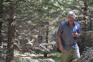
This hashpoint was within the municipality of Sotkamo, near the road to Pöppölä. We had to walk only 170 meters. The point was among very thick patch of spruces. It was a miracle the satellites could locate Pastori and The Wife from there.
Our stats from the four day trip from east to west and back were: 1150 km by car, a few kilometers wandering in the forest, and we visited 8 hashpoints, of which 6 succeeded perfectly. We scored no less than four virgin graticules and concluded our trip with three successful hashes on single day! Beat that!
Additional photos
Achievements
Pastori achieved level 4 of the Minesweeper Geohash achievement
|
Pastori and The Wife earned the Multihash Achievement
|
Pastori and The Wife earned the Consecutive geohash achievement
|
Pastori earned the Land geohash achievement
|


