Difference between revisions of "2013-06-01 32 -117"
From Geohashing
imported>LucasBrown |
imported>FippeBot m (Location) |
||
| (2 intermediate revisions by one other user not shown) | |||
| Line 16: | Line 16: | ||
Image:2013-06-01_32_-117_11-39-59-055.jpg | Geohash Droid details page at the hashpoint ([[User:LucasBrown|LucasBrown]]) | Image:2013-06-01_32_-117_11-39-59-055.jpg | Geohash Droid details page at the hashpoint ([[User:LucasBrown|LucasBrown]]) | ||
Image:2013-06-01_32_-117_11-41-32-085.jpg | Map at the hashpoint ([[User:LucasBrown|LucasBrown]]) | Image:2013-06-01_32_-117_11-41-32-085.jpg | Map at the hashpoint ([[User:LucasBrown|LucasBrown]]) | ||
| + | Image:2013-06-01_32_-117_11-43-57-097.jpg | Rusty gate near the hashpoint | ||
</gallery> | </gallery> | ||
| Line 21: | Line 22: | ||
[[Category:Expeditions with photos]] | [[Category:Expeditions with photos]] | ||
[[Category:Coordinates reached]] | [[Category:Coordinates reached]] | ||
| + | {{location|US|CA|SD}} | ||
Latest revision as of 02:38, 14 August 2019
| Sat 1 Jun 2013 in 32,-117: 32.6477531, -117.1495333 geohashing.info google osm bing/os kml crox |
Location
Right on the Silver Strand beach
Participants
- JesseW (talk)
- LucasBrown (independent expedition; reached the hashpoint at 12:43 PDT)
Plans
Head over there sometime today. -- JesseW (talk) 13:51, 1 June 2013 (EDT)
Photos
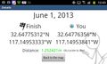
Geohash Droid details page at the hashpoint (LucasBrown)
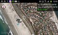
Map at the hashpoint (LucasBrown)
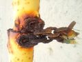
Rusty gate near the hashpoint


