Difference between revisions of "2013-06-06 54 -3"
imported>Alexandersmith (→Participants) |
imported>FippeBot m (Location) |
||
| (9 intermediate revisions by one other user not shown) | |||
| Line 19: | Line 19: | ||
== Location == | == Location == | ||
Parkhouse Road, Barrow-in-Furness. | Parkhouse Road, Barrow-in-Furness. | ||
| + | |||
| + | The road is "busy" for what looks like a minor country road, and because it joins two parts of the town it does get used as a short-cut. I know, I've done it myself. | ||
== Participants == | == Participants == | ||
| − | + | [[User:Alexandersmith|Alexandersmith]] ([[User talk:Alexandersmith|talk]]) | |
== Plans == | == Plans == | ||
| − | + | I am planning to cycle to the hash, with an attempt on the TRON award for the entire journey. | |
== Expedition == | == Expedition == | ||
| − | + | A text-book geohashing expedition. I cycled to the meet-up point, saw there was plenty of passing traffic, but nobody else seemed like they were from the internet. | |
| + | |||
| + | I captured a few images, and left, being careful to not cross my track on the way back. | ||
== Tracklog == | == Tracklog == | ||
| − | + | http://www.alxsmith.talktalk.net/xkcd/20130606.gpx | |
== Photos == | == Photos == | ||
| − | < | + | <gallery perrow="3"> |
| − | Image: | + | Image:20130606_GeohashAchieved.jpg | Droid Geohash app showing my proximity to the geohash point. |
| − | -- | + | Image:20130606_GeohashAutoPhoto.jpg | Auto-photo at the geo-hash. |
| − | + | Image:20130606_GeohashGeneralLocation.jpg | The general nature of the location. The location of the hash is in the centre of the image. | |
</gallery> | </gallery> | ||
== Achievements == | == Achievements == | ||
{{#vardefine:ribbonwidth|800px}} | {{#vardefine:ribbonwidth|800px}} | ||
| − | + | {{bicycle geohash | latitude = 54 | longitude = -3 | date = 2013-06-06 | name = [[User:Alexandersmith|Alexandersmith]] | distance = 8 miles | bothways = true }} | |
| − | + | {{Land geohash | latitude = 54 | longitude = -3 | date = 2013-06-06 | name = [[User:Alexandersmith|Alexandersmith]]}} | |
| − | |||
| − | |||
| − | |||
| − | |||
| − | |||
| − | |||
| − | |||
| − | |||
| − | |||
| − | |||
[[Category:Expeditions]] | [[Category:Expeditions]] | ||
| − | |||
[[Category:Expeditions with photos]] | [[Category:Expeditions with photos]] | ||
| − | |||
| − | |||
| − | |||
| − | |||
| − | |||
[[Category:Coordinates reached]] | [[Category:Coordinates reached]] | ||
| + | {{Tron | ||
| − | - | + | | latitude = 54 |
| − | + | | longitude = -3 | |
| − | + | | date = 2013-06-06 | |
| − | + | | tracklog = http://www.alxsmith.talktalk.net/xkcd/20130606.gpx | |
| − | + | | possessive = his | |
| − | + | | name = [[User:Alexandersmith|Alexandersmith]] ([[User talk:Alexandersmith|talk]]) | |
| − | + | }} | |
| − | [[ | + | {{location|GB|ENG|CMA}} |
| − | |||
| − | |||
| − | [[ | ||
| − | |||
| − | |||
| − | |||
| − | |||
| − | |||
Latest revision as of 02:43, 14 August 2019
| Thu 6 Jun 2013 in 54,-3: 54.1325924, -3.1886021 geohashing.info google osm bing/os kml crox |
Location
Parkhouse Road, Barrow-in-Furness.
The road is "busy" for what looks like a minor country road, and because it joins two parts of the town it does get used as a short-cut. I know, I've done it myself.
Participants
Plans
I am planning to cycle to the hash, with an attempt on the TRON award for the entire journey.
Expedition
A text-book geohashing expedition. I cycled to the meet-up point, saw there was plenty of passing traffic, but nobody else seemed like they were from the internet.
I captured a few images, and left, being careful to not cross my track on the way back.
Tracklog
http://www.alxsmith.talktalk.net/xkcd/20130606.gpx
Photos

Droid Geohash app showing my proximity to the geohash point.
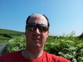
Auto-photo at the geo-hash.
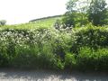
The general nature of the location. The location of the hash is in the centre of the image.


Achievements
Alexandersmith earned the Bicycle geohash achievement
|
Alexandersmith earned the Land geohash achievement
|
Alexandersmith (talk) earned the Tron achievement
|