Difference between revisions of "2013-06-08 52 -1"
From Geohashing
imported>Nickholden (This does not look like a cycle path. And it wasn't. Oops.) |
imported>Palmpje m (Set result codes) |
||
| Line 56: | Line 56: | ||
<!-- =============== USEFUL CATEGORIES FOLLOW ================ | <!-- =============== USEFUL CATEGORIES FOLLOW ================ | ||
Delete the next line ONLY if you have chosen the appropriate categories below. If you are unsure, don't worry. People will read your report and help you with the classification. --> | Delete the next line ONLY if you have chosen the appropriate categories below. If you are unsure, don't worry. People will read your report and help you with the classification. --> | ||
| − | |||
| − | |||
| − | |||
| − | |||
| − | |||
[[Category:Expeditions]] | [[Category:Expeditions]] | ||
| − | |||
[[Category:Expeditions with photos]] | [[Category:Expeditions with photos]] | ||
| − | |||
| − | |||
| − | |||
| − | |||
| − | |||
[[Category:Coordinates reached]] | [[Category:Coordinates reached]] | ||
| − | |||
| − | |||
| − | |||
| − | |||
| − | |||
| − | |||
| − | |||
| − | |||
| − | |||
| − | |||
| − | |||
| − | |||
| − | |||
| − | |||
| − | |||
| − | |||
| − | |||
| − | |||
Revision as of 08:11, 9 June 2013
| Sat 8 Jun 2013 in 52,-1: 52.2897934, -1.3964875 geohashing.info google osm bing/os kml crox |
Location
Long Itchington, Warwickshire. In a farm field off Marton Road.
Participants
Plans
Looks like a nice day for a bike ride. It's also the first day of Strava's "fi'zi:k Tour Tune-Up" so clocking some time in the saddle will be good. Aiming to be at the hashpoint about 4pm, wind and leg muscles permitting.
Expedition
- Got lost in Rugby on the way there, and found lots of bonus hills that were not on the route. And then got lost on the way home leading to an impromptu wander around a golf course. Strange day.
On the other hand, got right to the hash point where someone was growing potatoes. And clocked 109km which makes this my longest ride ever. -- Nickholden (talk) @52.5803,-1.1022 22:22, 8 June 2013 (GMT+01:00)
Tracklog
Photos
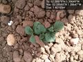
Potatoes! @52.2898,-1.3965

Cheesy grin and a potato field @52.2898,-1.3965
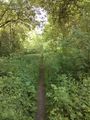
This does not look like a cycle path. And it wasn't. Oops.


