Difference between revisions of "2013-06-16 48 9"
From Geohashing
imported>Kobras (An expedition message sent via Geohash Droid for Android.) |
imported>FippeBot m (Location) |
||
| (3 intermediate revisions by 2 users not shown) | |||
| Line 19: | Line 19: | ||
== Location == | == Location == | ||
<!-- where you've surveyed the hash to be --> | <!-- where you've surveyed the hash to be --> | ||
| + | Near Dettingen an der Erms | ||
== Participants == | == Participants == | ||
<!-- who attended: If you link to your wiki user name in this section, your expedition will be picked up by the various statistics generated for geohashing. You may use three tildes ~ as a shortcut to automatically insert the user signature of the account you are editing with. | <!-- who attended: If you link to your wiki user name in this section, your expedition will be picked up by the various statistics generated for geohashing. You may use three tildes ~ as a shortcut to automatically insert the user signature of the account you are editing with. | ||
--> | --> | ||
| + | * [[User:Kobras|Kobras]] | ||
| + | * Don | ||
== Plans == | == Plans == | ||
<!-- what were the original plans --> | <!-- what were the original plans --> | ||
| + | Finally reach a geohash without the GPS batteries running flat shortly before reaching the final destination. | ||
== Expedition == | == Expedition == | ||
<!-- how it all turned out. your narrative goes here. --> | <!-- how it all turned out. your narrative goes here. --> | ||
| − | + | Don and me made it to the destination near Dettingen, first by car on a series of decreasingly less main roads, then went for a short walk to the final location. The geohash was between some trees right next to a track, overseeing lovely Erms valley. [http://www.openstreetmap.org/?lat=48.51050000&lon=9.35571000&zoom=16&layers=B000FTF @48.5105,9.3557] | |
| − | == | ||
| − | |||
== Photos == | == Photos == | ||
| Line 38: | Line 40: | ||
--> | --> | ||
<gallery perrow="5"> | <gallery perrow="5"> | ||
| + | |||
| + | Image:2013-06-16_48_9_21-46-23-710.jpg | Don and me at hash location | ||
</gallery> | </gallery> | ||
| Line 44: | Line 48: | ||
<!-- Add any achievement ribbons you earned below, or remove this section --> | <!-- Add any achievement ribbons you earned below, or remove this section --> | ||
| − | |||
| − | |||
| − | |||
| − | |||
| − | |||
| − | |||
| − | |||
| − | |||
| − | |||
| − | |||
| − | |||
[[Category:Expeditions]] | [[Category:Expeditions]] | ||
| − | |||
[[Category:Expeditions with photos]] | [[Category:Expeditions with photos]] | ||
| − | |||
| − | |||
| − | |||
| − | |||
| − | |||
[[Category:Coordinates reached]] | [[Category:Coordinates reached]] | ||
| − | + | <!-- or if you failed :( | |
| − | |||
[[Category:Coordinates not reached]] | [[Category:Coordinates not reached]] | ||
-- and a reason -- | -- and a reason -- | ||
| Line 82: | Line 68: | ||
(Don't forget to delete this final close comment marker) --> | (Don't forget to delete this final close comment marker) --> | ||
| + | {{location|DE|BW|RT}} | ||
Latest revision as of 02:51, 14 August 2019
| Sun 16 Jun 2013 in 48,9: 48.5105090, 9.3556832 geohashing.info google osm bing/os kml crox |
Location
Near Dettingen an der Erms
Participants
- Kobras
- Don
Plans
Finally reach a geohash without the GPS batteries running flat shortly before reaching the final destination.
Expedition
Don and me made it to the destination near Dettingen, first by car on a series of decreasingly less main roads, then went for a short walk to the final location. The geohash was between some trees right next to a track, overseeing lovely Erms valley. @48.5105,9.3557
Photos
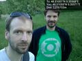
Don and me at hash location
