Difference between revisions of "2013-06-17 39 -77"
From Geohashing
imported>OfficeLinebacker ([live picture]) |
imported>FippeBot m (Location) |
||
| (10 intermediate revisions by 2 users not shown) | |||
| Line 19: | Line 19: | ||
== Location == | == Location == | ||
<!-- where you've surveyed the hash to be --> | <!-- where you've surveyed the hash to be --> | ||
| + | In some woods in Ashton, MD | ||
== Participants == | == Participants == | ||
<!-- who attended: If you link to your wiki user name in this section, your expedition will be picked up by the various statistics generated for geohashing. You may use three tildes ~ as a shortcut to automatically insert the user signature of the account you are editing with. | <!-- who attended: If you link to your wiki user name in this section, your expedition will be picked up by the various statistics generated for geohashing. You may use three tildes ~ as a shortcut to automatically insert the user signature of the account you are editing with. | ||
--> | --> | ||
| + | *Friend of [[User:OfficeLinebacker|OfficeLinebacker]] | ||
== Plans == | == Plans == | ||
| Line 29: | Line 31: | ||
== Expedition == | == Expedition == | ||
<!-- how it all turned out. your narrative goes here. --> | <!-- how it all turned out. your narrative goes here. --> | ||
| + | I didn't make it to this one. A friend borrowed my phone and I guess she got there, though the battery died shortly thereafter. | ||
| + | |||
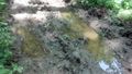
| + | She said it was very muddy and damp and there were lots of frogs as well as muddy trails with hoofprints. But she didn't see any horses or horse farms. | ||
== Tracklog == | == Tracklog == | ||
| Line 40: | Line 45: | ||
Image:2013-06-17_39_-77_12-01-46-268.jpg | | Image:2013-06-17_39_-77_12-01-46-268.jpg | | ||
| + | |||
| + | Image:2013-06-17_39_-77_12-02-38-798.jpg | | ||
| + | |||
| + | Image:2013-06-17_39_-77_12-07-09-307.jpg | Hoof prints" [http://www.openstreetmap.org/?lat=39.16950617&lon=-77.03971037&zoom=16&layers=B000FTF @39.1695,-77.0397] | ||
| + | |||
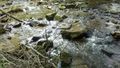
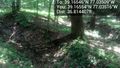
| + | Image:2013-06-17_39_-77_12-11-35-611.jpg | Treacherous | ||
| + | |||
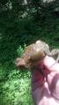
| + | Image:2013-06-17_39_-77_12-36-32-909.jpg | Geofauna [http://www.openstreetmap.org/?lat=39.16560872&lon=-77.03512913&zoom=16&layers=B000FTF @39.1656,-77.0351] | ||
| + | |||
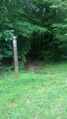
| + | Image:2013-06-17_39_-77_12-39-11-264.jpg | The spot [http://www.openstreetmap.org/?lat=39.16553902&lon=-77.03516087&zoom=16&layers=B000FTF @39.1655,-77.0352] | ||
| + | |||
| + | Image:2013-06-17_39_-77_14-25-36-825.jpg | | ||
</gallery> | </gallery> | ||
| Line 46: | Line 63: | ||
<!-- Add any achievement ribbons you earned below, or remove this section --> | <!-- Add any achievement ribbons you earned below, or remove this section --> | ||
| − | |||
| − | |||
| − | |||
| − | |||
| − | |||
| − | |||
| − | |||
| − | |||
| − | |||
| − | |||
| − | |||
[[Category:Expeditions]] | [[Category:Expeditions]] | ||
| − | |||
[[Category:Expeditions with photos]] | [[Category:Expeditions with photos]] | ||
| − | |||
| − | |||
| − | |||
| − | |||
| − | |||
[[Category:Coordinates reached]] | [[Category:Coordinates reached]] | ||
| − | + | {{location|US|MD|MO}} | |
| − | |||
| − | |||
| − | |||
| − | |||
| − | |||
| − | |||
| − | |||
| − | |||
| − | |||
| − | |||
| − | |||
| − | |||
| − | |||
| − | |||
| − | |||
| − | |||
| − | |||
Latest revision as of 02:52, 14 August 2019
| Mon 17 Jun 2013 in 39,-77: 39.1654562, -77.0350864 geohashing.info google osm bing/os kml crox |
Location
In some woods in Ashton, MD
Participants
- Friend of OfficeLinebacker
Plans
Expedition
I didn't make it to this one. A friend borrowed my phone and I guess she got there, though the battery died shortly thereafter.
She said it was very muddy and damp and there were lots of frogs as well as muddy trails with hoofprints. But she didn't see any horses or horse farms.
Tracklog
Photos
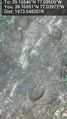
Hoof prints" @39.1695,-77.0397
Treacherous
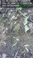
Geofauna @39.1656,-77.0351
The spot @39.1655,-77.0352