Difference between revisions of "2013-06-23 54 -1"
imported>Mcbaneg |
imported>FippeBot m (Location) |
||
| (15 intermediate revisions by 2 users not shown) | |||
| Line 1: | Line 1: | ||
<!-- If you did not specify these parameters in the template, please substitute appropriate values for IMAGE, LAT, LON, and DATE (YYYY-MM-DD format) | <!-- If you did not specify these parameters in the template, please substitute appropriate values for IMAGE, LAT, LON, and DATE (YYYY-MM-DD format) | ||
| − | [[{{{image| | + | [[{{{image|Wirehorse.jpg}}}|800px]] |
Remove this section if you don't want an image at the top (left) of your report. You should remove the "Image:" or "File:" | Remove this section if you don't want an image at the top (left) of your report. You should remove the "Image:" or "File:" | ||
| Line 8: | Line 8: | ||
And DON'T FORGET to add your expedition and the best photo you took to the gallery on the Main Page! We'd love to read your report, but that means we first have to discover it! :) | And DON'T FORGET to add your expedition and the best photo you took to the gallery on the Main Page! We'd love to read your report, but that means we first have to discover it! :) | ||
--> | --> | ||
| − | [[Image:{{{image| | + | [[Image:{{{image|Wirehorse.JPG}}}|thumb|left]] |
{{meetup graticule | {{meetup graticule | ||
| Line 26: | Line 26: | ||
*Rebekah | *Rebekah | ||
*Jake | *Jake | ||
| − | *Jessica | + | *Jessica |
| Line 76: | Line 76: | ||
--> | --> | ||
<gallery perrow="4"> | <gallery perrow="4"> | ||
| − | Image:Rebekah_at_gate. | + | Image:Rebekah_at_gate.jpeg | This gate we COULD go through. |
| − | Image: | + | Image:Waskerley_way.jpeg | So long as we didn't have motorcycles. (Check.) |
| − | Image: | + | Image:GKRJ.jpeg | At the hashpoint: George, Katja, Rebekah, Jess. |
| − | Image: | + | Image:GKRJ2.jpeg | At the hashpoint, Jake now. Notice that George REALLY doesn't like camera flashes at night. |
| − | Image: | + | Image:Wirehorse.JPG | Big sculpture on the hill above the hashpoint. Photo taken ca. 11:15 pm. For a daytime shot (by someone else) see [http://www.panoramio.com/photo/51885587 http://www.panoramio.com/photo/51885587] |
| − | Image: | + | Image:GPS_reading.jpeg | The reading was too unstable to do better than this. |
| + | Image:Midnight.jpeg | Midnight! | ||
</gallery> | </gallery> | ||
| Line 87: | Line 88: | ||
{{#vardefine:ribbonwidth|800px}} | {{#vardefine:ribbonwidth|800px}} | ||
<!-- Add any achievement ribbons you earned below, or remove this section --> | <!-- Add any achievement ribbons you earned below, or remove this section --> | ||
| + | |||
| + | {{land geohash | ||
| + | | latitude = 54 | ||
| + | | longitude = -1 | ||
| + | | date = 2013-06-23 | ||
| + | | name = George, Katja, Rebekah, Jake, and Jessica | ||
| + | }} | ||
{{Midnight geohash | {{Midnight geohash | ||
| Line 92: | Line 100: | ||
| longitude = -1 | | longitude = -1 | ||
| date = 2013-06-23 | | date = 2013-06-23 | ||
| − | | name = George, Katja, Rebekah, Jake, Jessica | + | | name = George, Katja, Rebekah, Jake, and Jessica |
| − | | image = GKRJ.jpg | + | <!-- | image = GKRJ.jpg --> |
}} | }} | ||
| − | |||
<!-- =============== USEFUL CATEGORIES FOLLOW ================ | <!-- =============== USEFUL CATEGORIES FOLLOW ================ | ||
| Line 105: | Line 112: | ||
[[Category:Expeditions with photos]] | [[Category:Expeditions with photos]] | ||
[[Category:Coordinates reached]] | [[Category:Coordinates reached]] | ||
| − | + | {{location|GB|ENG|DUR}} | |
| − | |||
| − | |||
| − | |||
| − | |||
| − | |||
| − | |||
| − | |||
| − | |||
| − | |||
| − | |||
| − | |||
| − | |||
| − | |||
| − | |||
| − | |||
| − | |||
| − | |||
| − | |||
| − | |||
| − | |||
| − | |||
| − | |||
| − | |||
| − | |||
| − | |||
| − | |||
| − | |||
Latest revision as of 02:56, 14 August 2019

| Sun 23 Jun 2013 in 54,-1: 54.7840435, -1.9946319 geohashing.info google osm bing/os kml crox |
Location
moorland/pasture north of Stanhope on the northern rim of Weardale, County Durham, UK
Participants
Plans
We're planning to head up there this evening, hoping to have enough light still at 11 pm or so to find the spot, and be there for the midnight hash.
Expedition
Northern summer twilight held for us. We arrived at the parking lot of the nearby B&B (which seemed to have a good number of clients; nice to see) around 10:45. As we walked past its restaurant, a guy came out asking us "are you guests here?" We responded "No, we're just trying to get to a spot on the moor a little over that way." "Okay", he says, "you can walk along this road, but don't go through that gate to the other side of the fence." The gate had a house trailer and a big dog on the other side of it, so we were happy not to go through it, but there was some worry that the fence might extend a long way north and block our access to the moor. As it turned out, walking north just a little way brought us to a public cycleway, from which there was no impediment other than boggy moorland blocking our route. After some tussock-hopping (thank you summer solstice for just-adequate illumination) we arrived on firmer ground and had no trouble finding the narrow grassy path that showed up on the satellite image. The hashpoint was along that path a few feet away from a Y-intersection, and there was also a big barn for orientation, so we found the spot without problems.
Cellphone locator service was working better than usual out in the dales, but was still a little flaky; moving about three feet could change its distance-to-target estimate by ten yards or so, and there was no way to play "warmer/colder" to get a better marker than the highest-resolution satellite map had already given us. We took a picture of the cellphone screen anyway, giving a distance estimate of 6.16 yards.
The ladies went exploring around the heather a little while, encountering a family of grouse, to make the time to midnight pass faster. In fact they were surprised to find that when they got back to Jake and me it was only twelve minutes to midnight! We waited around the remaining time, huddling to keep the cool wind at bay, took a picture of my cellphone clock showing midnight (we liked that one because it was the most advanced), declared victory, and headed for home. There was a pub open in Stanhope but it was probably a little farther away from the hashpoint than the Pub Hash requirements, our party included two underage people, and anyway we were all ready to turn in, so we passed it up.
Photos
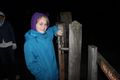
This gate we COULD go through.
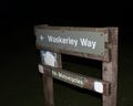
So long as we didn't have motorcycles. (Check.)
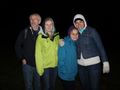
At the hashpoint: George, Katja, Rebekah, Jess.
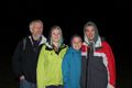
At the hashpoint, Jake now. Notice that George REALLY doesn't like camera flashes at night.
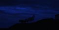
Big sculpture on the hill above the hashpoint. Photo taken ca. 11:15 pm. For a daytime shot (by someone else) see http://www.panoramio.com/photo/51885587
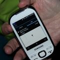
The reading was too unstable to do better than this.

Midnight!


Achievements
George, Katja, Rebekah, Jake, and Jessica earned the Land geohash achievement
|
George, Katja, Rebekah, Jake, and Jessica earned the Midnight Geohash achievement
|