Difference between revisions of "2013-06-24 43 27"
From Geohashing
imported>Kisolre (An expedition message sent via Geohash Droid for Android.) |
imported>FippeBot m (Location) |
||
| (4 intermediate revisions by 2 users not shown) | |||
| Line 18: | Line 18: | ||
__NOTOC__ | __NOTOC__ | ||
== Location == | == Location == | ||
| − | + | A meadow near Smolnitsa village (population: 5). | |
== Participants == | == Participants == | ||
| − | + | *[[User:Kisolre|Kisolre]] | |
| − | |||
== Plans == | == Plans == | ||
| Line 38: | Line 37: | ||
--> | --> | ||
<gallery perrow="5"> | <gallery perrow="5"> | ||
| + | |||
| + | Image:2013-06-24_43_27_16-04-23-400.jpg | Proof [http://www.openstreetmap.org/?lat=43.62884829&lon=27.72119712&zoom=16&layers=B000FTF @43.6288,27.7212] | ||
| + | |||
| + | Image:2013-06-24_43_27_16-06-23-550.jpg | Panorama at the hash [http://www.openstreetmap.org/?lat=43.62880000&lon=27.72120000&zoom=16&layers=B000FTF @43.6288,27.7212] | ||
| + | |||
| + | Image:2013-06-24_43_27_16-07-56-415.jpg | Stupid grin :-) [http://www.openstreetmap.org/?lat=43.62880000&lon=27.72120000&zoom=16&layers=B000FTF @43.6288,27.7212] | ||
</gallery> | </gallery> | ||
| Line 45: | Line 50: | ||
| − | |||
| − | |||
| − | |||
| − | |||
| − | |||
| − | |||
| − | |||
| − | |||
| − | |||
[[Category:Expeditions]] | [[Category:Expeditions]] | ||
| − | |||
[[Category:Expeditions with photos]] | [[Category:Expeditions with photos]] | ||
| − | |||
| − | |||
| − | |||
| − | |||
| − | |||
[[Category:Coordinates reached]] | [[Category:Coordinates reached]] | ||
| − | + | {{location|BG|TX}} | |
| − | |||
| − | |||
| − | |||
| − | |||
| − | |||
| − | |||
| − | |||
| − | |||
| − | |||
| − | |||
| − | |||
| − | |||
| − | |||
| − | |||
| − | |||
| − | |||
| − | |||
Latest revision as of 06:07, 6 August 2019
| Mon 24 Jun 2013 in 43,27: 43.6288472, 27.7212401 geohashing.info google osm bing/os kml crox |
Location
A meadow near Smolnitsa village (population: 5).
Participants
Plans
Expedition
Tracklog
Photos
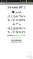
Proof @43.6288,27.7212

Panorama at the hash @43.6288,27.7212

Stupid grin :-) @43.6288,27.7212

