Difference between revisions of "2013-06-29 60 24"
imported>Nebini (Created page with "{{subst:Expedition |lat = 60 |lon = 24 |date = 2013-06-29 }}") |
imported>Nebini (Expedition report) |
||
| Line 1: | Line 1: | ||
| − | |||
| − | |||
| − | |||
| − | |||
| − | |||
| − | |||
| − | |||
| − | |||
| − | |||
| − | |||
{{meetup graticule | {{meetup graticule | ||
| lat=60 | | lat=60 | ||
| Line 18: | Line 8: | ||
__NOTOC__ | __NOTOC__ | ||
== Location == | == Location == | ||
| − | + | ||
| + | Kirkkonummi, in dense forest. About 2.5 km from the front gate of Upinniemi naval base. | ||
== Participants == | == Participants == | ||
| − | + | ||
| − | + | [[User:Nebini|Nebini]] | |
== Plans == | == Plans == | ||
| − | < | + | [[User:Tilley|Tilley]] accidentally mentioned Geohashing at IRC. |
| + | 20:57 < Tilley> hmm, väärä kanava, mutta eipä mitään.. Geohashingista siis kyse, joskus | ||
| + | täälläkin oon maininnut. http://wiki.xkcd.com/geohashing/Main_Page | ||
| + | A conversation started and I looked if there were any reachable locations nearby. This location seemed reachable by bike. Plan was to cycle there and back using shortest route possible 2x31 km. | ||
== Expedition == | == Expedition == | ||
| − | |||
| − | + | Route seemed easy on paper, but recent improvements to road 51 caused few detours. Additional places visited included Peuramaa golf course and [http://www.maatilapuoti.fi/ Maatilapuoti ] a hybrid between cafe and farmer's market. | |
| − | + | ||
| + | Actual place was a swamp with lots of mosquitoes and raw mulberries. A bottle of insect repellant would have been a nice addition to gear. | ||
| + | |||
== Photos == | == Photos == | ||
| − | |||
| − | |||
| − | |||
<gallery perrow="5"> | <gallery perrow="5"> | ||
| + | File:2013-06-29_60_24_mulberry.jpeg | Raw mulberry with the GPS | ||
| + | File:2013-06-29_60_24_approach.jpeg | End of official road, less than 100m to meetup | ||
| + | File:2013-06-29_60_24_shop.jpeg | Maatilapuoti | ||
</gallery> | </gallery> | ||
| Line 45: | Line 40: | ||
| − | |||
| − | |||
[[Category:New report]] | [[Category:New report]] | ||
| − | + | [[Category:Expeditions with photos]] | |
| − | |||
| − | [[Category: | ||
| − | |||
| − | |||
| − | |||
[[Category:Expeditions]] | [[Category:Expeditions]] | ||
| − | |||
| − | |||
| − | |||
| − | |||
| − | |||
| − | |||
| − | |||
[[Category:Coordinates reached]] | [[Category:Coordinates reached]] | ||
| − | |||
| − | |||
| − | |||
| − | |||
| − | |||
| − | |||
| − | |||
| − | |||
| − | |||
| − | |||
| − | |||
| − | |||
| − | |||
| − | |||
| − | |||
| − | |||
| − | |||
| − | |||
Revision as of 20:44, 29 June 2013
| Sat 29 Jun 2013 in 60,24: 60.0695241, 24.3760538 geohashing.info google osm bing/os kml crox |
Location
Kirkkonummi, in dense forest. About 2.5 km from the front gate of Upinniemi naval base.
Participants
Plans
Tilley accidentally mentioned Geohashing at IRC.
20:57 < Tilley> hmm, väärä kanava, mutta eipä mitään.. Geohashingista siis kyse, joskus
                täälläkin oon maininnut. http://wiki.xkcd.com/geohashing/Main_Page
A conversation started and I looked if there were any reachable locations nearby. This location seemed reachable by bike. Plan was to cycle there and back using shortest route possible 2x31 km.
Expedition
Route seemed easy on paper, but recent improvements to road 51 caused few detours. Additional places visited included Peuramaa golf course and Maatilapuoti a hybrid between cafe and farmer's market.
Actual place was a swamp with lots of mosquitoes and raw mulberries. A bottle of insect repellant would have been a nice addition to gear.
Photos
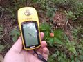
Raw mulberry with the GPS
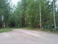
End of official road, less than 100m to meetup
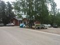
Maatilapuoti


