Difference between revisions of "2013-07-05 42 -87"
imported>Swoop2 (→Expedition) |
imported>FippeBot m (Location) |
||
| (12 intermediate revisions by 4 users not shown) | |||
| Line 25: | Line 25: | ||
*[[User:Swoop2|Swoop2]] | *[[User:Swoop2|Swoop2]] | ||
*[[User:TJAMM|TJAMM]] | *[[User:TJAMM|TJAMM]] | ||
| + | *[[User:Haberdasher|Haberdasher]] | ||
== Plans == | == Plans == | ||
<!-- what were the original plans --> | <!-- what were the original plans --> | ||
Heading out from work during my lunch break. We should be there around 12:30. After that we are heading to Smash Burger! | Heading out from work during my lunch break. We should be there around 12:30. After that we are heading to Smash Burger! | ||
| + | |||
| + | I ([[User:Haberdasher|Haberdasher]]) hadn't seen the above plans in time and was uncertain about the practicality of this hashpoint anyway, but has found time for reaching it later in the evening, hoping to arrive around 6:30 PM. | ||
== Expedition == | == Expedition == | ||
| − | We (TJAMM and I) arrived at the park shortly after noon. It was beautiful weather in a cute, little park. A fountain gurgled nearby. People were sitting around reading or eating lunch. We strolled to the geohash location between a shady tree and a park bench. | + | We (TJAMM and I) arrived at the park shortly after noon. It was beautiful weather in a cute, little park. A fountain gurgled nearby. People were sitting around reading or eating lunch. We strolled to the geohash location between a shady tree and a park bench. In all a very nice place to visit. I'm glad we went. |
| − | + | I ([[User:Haberdasher|Haberdasher]]) ended up getting there around 7:15 due to reasons. It was still light out, and the weather was indeed nice. There was a festival going on, so the park was somewhat busy and finding a parking space was a bit challenging, but the actual hashpoint itself was quite easy to reach. After some GPS-dancing and inspecting passersby on the off-chance that they too were geohashers, I headed out, my first geohash in over a month successfully completed. | |
| − | |||
== Photos == | == Photos == | ||
| Line 41: | Line 43: | ||
--> | --> | ||
<gallery perrow="5"> | <gallery perrow="5"> | ||
| + | Image:2013-07-05_42_-88_bench.png | Bench | ||
| + | Image:2013-07-05_42_-88_fountain.png | Fountain | ||
| + | Image:2013-07-05_42_-88_marker.png | The nearest brick | ||
| + | Image:2013-07-05_42_-88_shotgun.png | Partner in... geohash! | ||
| + | </gallery> | ||
| + | |||
| + | <gallery perrow="5"> | ||
| + | Image:2013-07-05_42_-87Fountain.JPG | Fountain | ||
| + | Image:2013-07-05_42_-87GPS.JPG | GPS | ||
| + | Image:2013-07-05_42_-87StupidGrin.JPG | Stupid Grin | ||
</gallery> | </gallery> | ||
| Line 47: | Line 59: | ||
<!-- Add any achievement ribbons you earned below, or remove this section --> | <!-- Add any achievement ribbons you earned below, or remove this section --> | ||
| + | {{Minesweeper geohash | ||
| + | | graticule = Aurora, Illinois | ||
| + | | ranknumber = 2 | ||
| + | | ne = true | ||
| + | | e = true | ||
| + | | name = Haberdasher | ||
| + | }} | ||
| − | |||
| − | |||
| − | |||
| − | |||
| − | |||
| − | |||
| − | |||
| − | |||
| − | |||
[[Category:Expeditions]] | [[Category:Expeditions]] | ||
| − | |||
[[Category:Expeditions with photos]] | [[Category:Expeditions with photos]] | ||
| − | |||
| − | |||
| − | |||
| − | |||
| − | |||
[[Category:Coordinates reached]] | [[Category:Coordinates reached]] | ||
| − | + | {{location|US|IL|CO}} | |
| − | |||
| − | |||
| − | |||
| − | |||
| − | |||
| − | |||
| − | |||
| − | |||
| − | |||
| − | |||
| − | |||
| − | |||
| − | |||
| − | |||
| − | |||
| − | |||
| − | |||
Latest revision as of 03:02, 14 August 2019
| Fri 5 Jul 2013 in 42,-87: 42.0863438, -87.9809153 geohashing.info google osm bing/os kml crox |
Location
North School Park in Arlington Heights, Illinois
Participants
Plans
Heading out from work during my lunch break. We should be there around 12:30. After that we are heading to Smash Burger!
I (Haberdasher) hadn't seen the above plans in time and was uncertain about the practicality of this hashpoint anyway, but has found time for reaching it later in the evening, hoping to arrive around 6:30 PM.
Expedition
We (TJAMM and I) arrived at the park shortly after noon. It was beautiful weather in a cute, little park. A fountain gurgled nearby. People were sitting around reading or eating lunch. We strolled to the geohash location between a shady tree and a park bench. In all a very nice place to visit. I'm glad we went.
I (Haberdasher) ended up getting there around 7:15 due to reasons. It was still light out, and the weather was indeed nice. There was a festival going on, so the park was somewhat busy and finding a parking space was a bit challenging, but the actual hashpoint itself was quite easy to reach. After some GPS-dancing and inspecting passersby on the off-chance that they too were geohashers, I headed out, my first geohash in over a month successfully completed.
Photos
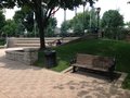
Bench

Fountain

The nearest brick

Partner in... geohash!


Fountain

GPS

Stupid Grin


Achievements
Haberdasher achieved level 2 of the Minesweeper Geohash achievement
|