Difference between revisions of "2013-07-15 51 8"
imported>GeorgDerReisende (Created page with "{{subst:Expedition |lat = 51 |lon = 8 |date = 2013-07-15 }}") |
imported>FippeBot m (Location) |
||
| (3 intermediate revisions by one other user not shown) | |||
| Line 1: | Line 1: | ||
| − | |||
| − | |||
| − | |||
| − | |||
| − | |||
| − | |||
| − | |||
| − | |||
| − | |||
{{meetup graticule | {{meetup graticule | ||
| lat=51 | | lat=51 | ||
| Line 18: | Line 9: | ||
__NOTOC__ | __NOTOC__ | ||
== Location == | == Location == | ||
| − | + | ||
| + | The hash of today lies in the middle of the motorway A44 shortly west of the interchange Wünnenberg-Haaren. | ||
== Participants == | == Participants == | ||
| − | + | ||
| − | + | [[User:GeorgDerReisende|GeorgDerReisende]] | |
== Plans == | == Plans == | ||
| − | + | ||
| + | I will go to the meetup graticule [[2013-07-15 51 7]] near Kamen by hitchhiking, so I have to pass this point. | ||
== Expedition == | == Expedition == | ||
| − | + | ||
| + | I started to hitchhike from the junction Wilhelmshöhe at the A44. The first car stopped after 25 minutes, which brought me to the service station ''Am Biggenkopf''. After another waiting time of 15 minutes the next car stopped and I got a lift to Dortmund. That car passed nearby the hash at about 11:50. | ||
== Tracklog == | == Tracklog == | ||
| − | + | ||
== Photos == | == Photos == | ||
| Line 38: | Line 32: | ||
--> | --> | ||
<gallery perrow="5"> | <gallery perrow="5"> | ||
| + | Image:2013-07-15 51 8 GeorgDerReisende 6537.jpg | beginning of the watch | ||
| + | Image:2013-07-15 51 8 GeorgDerReisende 6539.jpg | 1900 meters before the interchange Wünnenberg is 3700 meters before the hash | ||
| + | Image:2013-07-15 51 8 GeorgDerReisende 6541.jpg | look to the north from the motorway | ||
| + | Image:2013-07-15 51 8 GeorgDerReisende 6542.jpg | the GPS tells me, that I am near the hash | ||
| + | Image:2013-07-15 51 8 GeorgDerReisende 6543.jpg | short before the hash | ||
| + | Image:2013-07-15 51 8 GeorgDerReisende 6544.jpg | short behind the hash | ||
| + | Image:2013-07-15 51 8 GeorgDerReisende 6548.jpg | another view to the north of the motorway | ||
| + | Image:2013-07-15 51 8 GeorgDerReisende 6551.jpg | nearest place to the hash | ||
</gallery> | </gallery> | ||
== Achievements == | == Achievements == | ||
{{#vardefine:ribbonwidth|800px}} | {{#vardefine:ribbonwidth|800px}} | ||
| − | |||
| − | + | [[Category:Expeditions]] | |
| − | |||
| − | [[Category: | ||
| − | |||
| − | |||
| − | |||
| − | |||
| − | |||
| − | |||
| − | |||
| − | |||
[[Category:Expeditions with photos]] | [[Category:Expeditions with photos]] | ||
| − | |||
| − | |||
| − | |||
| − | |||
| − | |||
[[Category:Coordinates reached]] | [[Category:Coordinates reached]] | ||
| − | + | {{location|DE|NW|PB}} | |
| − | |||
| − | |||
| − | |||
| − | |||
| − | |||
| − | |||
| − | |||
| − | |||
| − | |||
| − | |||
| − | |||
| − | |||
| − | |||
| − | |||
| − | |||
| − | |||
| − | |||
Latest revision as of 03:11, 14 August 2019
| Mon 15 Jul 2013 in 51,8: 51.5865881, 8.7034166 geohashing.info google osm bing/os kml crox |
Location
The hash of today lies in the middle of the motorway A44 shortly west of the interchange Wünnenberg-Haaren.
Participants
Plans
I will go to the meetup graticule 2013-07-15 51 7 near Kamen by hitchhiking, so I have to pass this point.
Expedition
I started to hitchhike from the junction Wilhelmshöhe at the A44. The first car stopped after 25 minutes, which brought me to the service station Am Biggenkopf. After another waiting time of 15 minutes the next car stopped and I got a lift to Dortmund. That car passed nearby the hash at about 11:50.
Tracklog
Photos
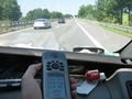
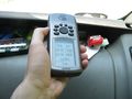
beginning of the watch
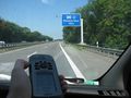
1900 meters before the interchange Wünnenberg is 3700 meters before the hash
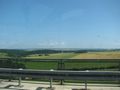
look to the north from the motorway
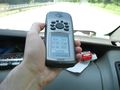
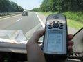
the GPS tells me, that I am near the hash
short before the hash
short behind the hash
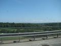
another view to the north of the motorway
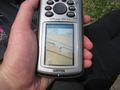
nearest place to the hash


