Difference between revisions of "2013-07-15 55 37"
From Geohashing
imported>Vb |
imported>FippeBot m (Location) |
||
| (3 intermediate revisions by one other user not shown) | |||
| Line 31: | Line 31: | ||
*~18km walk, half of it in the rain. -- [[User:Vb|vb]] ([[User talk:Vb|talk]]) [http://www.openstreetmap.org/?lat=55.58435950&lon=37.55942249&zoom=16&layers=B000FTF @55.5844,37.5594] 13:07, 15 July 2013 (EDT) | *~18km walk, half of it in the rain. -- [[User:Vb|vb]] ([[User talk:Vb|talk]]) [http://www.openstreetmap.org/?lat=55.58435950&lon=37.55942249&zoom=16&layers=B000FTF @55.5844,37.5594] 13:07, 15 July 2013 (EDT) | ||
== Tracklog == | == Tracklog == | ||
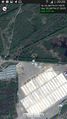
| − | + | [[Image:2013-07-15_55_37_vb_track.jpg|250px]] | |
| + | 17.1km | ||
== Photos == | == Photos == | ||
| Line 45: | Line 46: | ||
{{#vardefine:ribbonwidth|800px}} | {{#vardefine:ribbonwidth|800px}} | ||
<!-- Add any achievement ribbons you earned below, or remove this section --> | <!-- Add any achievement ribbons you earned below, or remove this section --> | ||
| + | |||
| + | {{Walk geohash | latitude = 55 | longitude = 37 | date = 2013-07-15 | name = [[User:Vb|vb]] | distance = 17.1km | image = 2013-07-15_55_37_vb_track.jpg }} | ||
[[Category:Expeditions]] | [[Category:Expeditions]] | ||
| Line 51: | Line 54: | ||
[[Category:Walk geohash achievement]] | [[Category:Walk geohash achievement]] | ||
[[Category:Land geohash achievement]] | [[Category:Land geohash achievement]] | ||
| + | {{location|RU|MOW}} | ||
Latest revision as of 03:11, 14 August 2019
| Mon 15 Jul 2013 in 55,37: 55.5865881, 37.7034166 geohashing.info google osm bing/os kml crox |
Location
What appears to be the north-east boundary of East Biryulevo district.
Participants
Expedition
- ~18km walk, half of it in the rain. -- vb (talk) @55.5844,37.5594 13:07, 15 July 2013 (EDT)
Tracklog
 17.1km
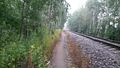
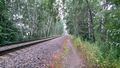
Photos
Coordinates reached.
At the hash.
Still at the hash
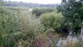
Not far away from the hash.


Achievements
vb earned the Walk geohash Achievement
|