Difference between revisions of "2013-07-08 52 1"
imported>MagicIan m (→Photos) |
imported>FippeBot m (Location) |
||
| Line 68: | Line 68: | ||
[[Category:Expeditions with photos]][[Category:Expeditions]][[Category:Coordinates reached]] | [[Category:Expeditions with photos]][[Category:Expeditions]][[Category:Coordinates reached]] | ||
| + | {{location|GB|ENG|NFK}} | ||
Latest revision as of 11:42, 16 August 2019
Location
In a small wood on the border between the villages of Fundenhall and Tacolneston.
| Mon 8 Jul 2013 in Norwich: 52.5183087, 1.1703466 geohashing.info google osm bing/os kml crox |
Participants
Expedition
Today's hash was at a place MagicIan had been very close to before as he regularly takes his motorbike along the B1113 as it is a nice road with lots of corners.
He reached the hashpoint in the middle of a horse-shoe type cycle route starting after work and ending up at home. It was a fairly short cycle (13.6 miles in total) on a hot and sunny summer afternoon. The hashpoint itself was found fairly easily after a brief walk through the woods which were not too thick with undergrowth.
Achievements
MagicIan earned the Bicycle geohash achievement
|
Photos
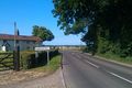
Photo of Fundenhall sign viewed from the road just by the hashpoint for Monday 08-07-2013, 52.5183087°, 1.1703466° (Norwich, United Kingdom)
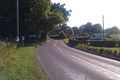
Photo of Tacolneston sign viewed from the road just by the hashpoint for Monday 08-07-2013, 52.5183087°, 1.1703466° (Norwich, United Kingdom)
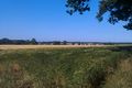
Photo of field next to the wood containing the hashpoint for Monday 08-07-2013, 52.5183087°, 1.1703466° (Norwich, United Kingdom)
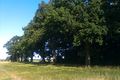
Photo of the wood containing the hashpoint for Monday 08-07-2013, 52.5183087°, 1.1703466° (Norwich, United Kingdom)
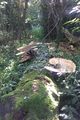
Photo of fungus growing on a fallen tree trunk in the wood containing the hashpoint for Monday 08-07-2013, 52.5183087°, 1.1703466° (Norwich, United Kingdom)
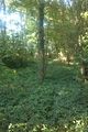
Photo taken at the hashpoint for Monday 08-07-2013, 52.5183087°, 1.1703466° (Norwich, United Kingdom)
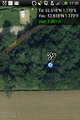
Phone screenshot showing proximity of the hashpoint for Monday 08-07-2013, 52.5183087°, 1.1703466° (Norwich, United Kingdom)


