Difference between revisions of "2013-07-26 51 6"
imported>GeorgDerReisende |
imported>GeorgDerReisende (did not start) |
||
| Line 22: | Line 22: | ||
== Expedition == | == Expedition == | ||
| − | + | ||
| + | I didn't start, because there had been a very bad weather forecast. A big cloud, looking like a big thunderstorm, had created over the Biscaya and traveled across France to North Rhine-Westfalia. At the time of approaching Germany it was already a heavy thunderstorm, while it passed Kassel, it was only some clouds of heavy rain. But lightnings are deadly for hitchhikers and though I don't like to hitchhike, if there is a thunderstorm only at the horizon. | ||
== Tracklog == | == Tracklog == | ||
| Line 28: | Line 29: | ||
== Photos == | == Photos == | ||
| − | |||
| − | |||
| − | |||
<gallery perrow="5"> | <gallery perrow="5"> | ||
| + | Image:2013-07-26 51 6 GeorgDerReisende I.NEW.jpg | a big cell created over the Biscaya | ||
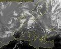
| + | Image:2013-07-26 51 6 GeorgDerReisende II.NEW.jpg | the cell is wandering across France to Germany | ||
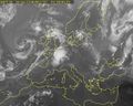
| + | Image:2013-07-26 51 6 GeorgDerReisende III.NEW.jpg | the cell is approaching Germany | ||
| + | Image:2013-07-26 51 6 GeorgDerReisende IIII.NEW.jpg | the evening after | ||
</gallery> | </gallery> | ||
| Line 39: | Line 41: | ||
| − | + | [[Category:Expeditions]] | |
| − | |||
| − | [[Category: | ||
| − | |||
| − | |||
| − | |||
| − | |||
| − | |||
| − | |||
| − | |||
| − | |||
[[Category:Expeditions with photos]] | [[Category:Expeditions with photos]] | ||
| − | |||
| − | |||
| − | |||
| − | |||
| − | |||
| − | |||
| − | |||
| − | |||
| − | |||
| − | |||
| − | |||
| − | |||
| − | |||
| − | |||
| − | |||
| − | |||
| − | |||
| − | |||
| − | |||
| − | |||
[[Category:Not reached - Did not attempt]] | [[Category:Not reached - Did not attempt]] | ||
| − | |||
| − | |||
Revision as of 06:07, 27 July 2013
| Fri 26 Jul 2013 in 51,6: 51.4892519, 6.8853541 geohashing.info google osm bing/os kml crox |
Location
The hash lies on the cyclepath of the Osterfelder Straße in Oberhausen just east of the CentrO.
Participants
Plans
I want to hitchhike to there. Now I know that the service station Am Haarstrang is a no-go for me, but I have to try.
After this hash I want to visit the 2013-07-26 52 6.
Expedition
I didn't start, because there had been a very bad weather forecast. A big cloud, looking like a big thunderstorm, had created over the Biscaya and traveled across France to North Rhine-Westfalia. At the time of approaching Germany it was already a heavy thunderstorm, while it passed Kassel, it was only some clouds of heavy rain. But lightnings are deadly for hitchhikers and though I don't like to hitchhike, if there is a thunderstorm only at the horizon.
Tracklog
Photos
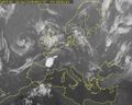
a big cell created over the Biscaya
the cell is wandering across France to Germany
the cell is approaching Germany
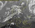
the evening after


