Difference between revisions of "2013-07-27 43 -116"
imported>Eldin ([live picture] Point [http://www.openstreetmap.org/?lat=43.87250000&lon=-116.49900000&zoom=16&layers=B000FTF @43.8725,-116.4990]) |
imported>FippeBot m (Location) |
||
| (3 intermediate revisions by one other user not shown) | |||
| Line 1: | Line 1: | ||
| − | {{ | + | {{meetup graticule |
| + | | lat=43 | ||
| + | | lon=-116 | ||
| + | | date=2013-07-27 | ||
| + | }} | ||
| + | |||
| + | |||
| + | __NOTOC__ | ||
| + | |||
| + | == Location == | ||
| + | In the hills NE of Emmet | ||
| + | |||
| + | == Participants == | ||
| + | * [[User:Eldin|Eldin]] | ||
| + | |||
| + | == Plans == | ||
| + | I'll try to reach the point this afternoon. | ||
| + | |||
| + | == Expedition == | ||
| + | I left home about 3pm, and drove towards Emmet. The trip there was uneventful, though I missed the turn off from the highway that I had intended to take. This turned out to be a good thing. By the time I realized I had missed it, it was easier to just take a different road and approach the hash from the opposite direction than to try to go back and find my turn. I had about 6 miles of winding dirt roads to traverse to reach the hashpoint. | ||
| + | |||
| + | I was starting to worry that this would turn into another no trespassing hash, because all the roads had fences and no trespassing markers along both sides. However, when I turned onto the road which would take me nearest the coordinates, I found that it went across the private property and into land with neither fences nor signs beyond it. I found a spot to park my car about 400m from the coordinates, and set out walking. Because of the steepness of some parts of the hill, I wasn't able to take a particularly direct route to the point, and between the hill and the heat I was sweating pretty heavily by the time I reached the spot, but I did reach it. | ||
| + | |||
| + | At this point, I realized I had left my camera in the car. I was still able to take pictures with my mobile phone, but since my phone is also my GPS device, I was unable to capture photographic proof that I had reached the coordinates. However, the geotagging information in some of my photos shows a location quite near to the correct coordinates. (the tag that geohash droid put into the photos uploaded from my phone is grossly inaccurate, as it sometimes is). I took some pictures anyway, and headed back down the hill to my car. | ||
| + | |||
| + | I decided to continue on and go back the way I had originally intended to come in to get back home. However, as I continued on, the road got progressively worse, eventually deteriorating to just a couple of ruts with plants and bushes growing in the middle. This primitive "road" eventually ended at a gate with a prominent no trespassing sign, so in the end, I had to turn around and go back the way I had originally come in. | ||
| + | |||
*At the point! -- [[User:Eldin|Eldin]] ([[User talk:Eldin|talk]]) [http://www.openstreetmap.org/?lat=43.95167943&lon=-116.44881342&zoom=16&layers=B000FTF @43.9517,-116.4488] 16:29, 27 July 2013 (MDT) | *At the point! -- [[User:Eldin|Eldin]] ([[User talk:Eldin|talk]]) [http://www.openstreetmap.org/?lat=43.95167943&lon=-116.44881342&zoom=16&layers=B000FTF @43.9517,-116.4488] 16:29, 27 July 2013 (MDT) | ||
| + | |||
| + | == Photos == | ||
<gallery> | <gallery> | ||
| − | Image:2013-07-27_43_-116_16-31-52-115.jpg | Grin | + | Image:2013-07-27_43_-116_16-31-52-115.jpg | Grin |
| + | Image:2013-07-27_43_-116_16-32-23-198.jpg | Point | ||
| + | Image:2013-07-27_43_-116_north.jpg | View looking north from the hash point. | ||
| + | Image:2013-07-27_43_-116_south.jpg | and the view to the south (back towards Emmet). | ||
| + | |||
| − | |||
</gallery> | </gallery> | ||
| + | |||
| + | == Achievements == | ||
| + | {{#vardefine:ribbonwidth|800px}} | ||
| + | {{Land geohash|latitude=43|longitude=-116|date=2013-07-27|name=[[User:Eldin|Eldin]]}} | ||
| + | {{consecutive geohash| count = 2| latitude = 43| longitude = -116| date = 2013-07-26| name = [[User:Eldin|Eldin]]}} | ||
| + | [[Category:Expeditions]] | ||
| + | [[Category:Expeditions with photos]] | ||
| + | [[Category:Coordinates reached]] | ||
| + | {{location|US|ID|GE}} | ||
Latest revision as of 06:14, 6 August 2019
| Sat 27 Jul 2013 in 43,-116: 43.9516838, -116.4488184 geohashing.info google osm bing/os kml crox |
Location
In the hills NE of Emmet
Participants
Plans
I'll try to reach the point this afternoon.
Expedition
I left home about 3pm, and drove towards Emmet. The trip there was uneventful, though I missed the turn off from the highway that I had intended to take. This turned out to be a good thing. By the time I realized I had missed it, it was easier to just take a different road and approach the hash from the opposite direction than to try to go back and find my turn. I had about 6 miles of winding dirt roads to traverse to reach the hashpoint.
I was starting to worry that this would turn into another no trespassing hash, because all the roads had fences and no trespassing markers along both sides. However, when I turned onto the road which would take me nearest the coordinates, I found that it went across the private property and into land with neither fences nor signs beyond it. I found a spot to park my car about 400m from the coordinates, and set out walking. Because of the steepness of some parts of the hill, I wasn't able to take a particularly direct route to the point, and between the hill and the heat I was sweating pretty heavily by the time I reached the spot, but I did reach it.
At this point, I realized I had left my camera in the car. I was still able to take pictures with my mobile phone, but since my phone is also my GPS device, I was unable to capture photographic proof that I had reached the coordinates. However, the geotagging information in some of my photos shows a location quite near to the correct coordinates. (the tag that geohash droid put into the photos uploaded from my phone is grossly inaccurate, as it sometimes is). I took some pictures anyway, and headed back down the hill to my car.
I decided to continue on and go back the way I had originally intended to come in to get back home. However, as I continued on, the road got progressively worse, eventually deteriorating to just a couple of ruts with plants and bushes growing in the middle. This primitive "road" eventually ended at a gate with a prominent no trespassing sign, so in the end, I had to turn around and go back the way I had originally come in.
- At the point! -- Eldin (talk) @43.9517,-116.4488 16:29, 27 July 2013 (MDT)
Photos

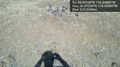
Grin
Point
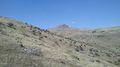
View looking north from the hash point.
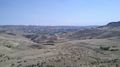
and the view to the south (back towards Emmet).


Achievements
Eldin earned the Land geohash achievement
|
Eldin earned the Consecutive geohash achievement
|