Difference between revisions of "2013-08-03 52 0"
From Geohashing
imported>Benjw (→Participants: +1) |
imported>Benjw (→Photographic documentation: add my single photo for expeditiaon) |
||
| Line 22: | Line 22: | ||
== Photographic documentation == | == Photographic documentation == | ||
| − | + | <gallery perrow="5"> | |
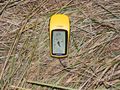
| − | Image: | + | Image:2013-08-03 52 0 gps.jpg | Ben's GPS showing hashpoint reached |
| − | </gallery | + | </gallery> |
== Shiny ribbons earned == | == Shiny ribbons earned == | ||
Revision as of 12:28, 4 August 2013
| Sat 3 Aug 2013 in Cambridge, UK: 52.7169253, 0.3540812 geohashing.info google osm bing/os kml crox |
Contents
Location
The west bank of the River Great Ouse just south of Kings Lynn, at the appropriately named Eau Brink Road.
Participants
- Benjw
- PaintedJaguar, and MrsPJ if she's not asleep
Plans
Given that the next day's hashpoint is so near here, Ben plans to combine both into a nighttime expedition, driving up from Cambridge and visiting Saturday's hash just before midnight, and Sunday's hash just after. He's very happy to change those plans or to give other hashers a lift if anyone else is interested.
The Great Ouse is tidal at this point, but, conveniently, low tide is at 00:47 so with a bit of luck the hashpoint will be on the river bank and not in the water.
Expedition
Photographic documentation
Ben's GPS showing hashpoint reached
