Difference between revisions of "2013-08-08 51 10"
imported>GeorgDerReisende (Created page with "{{subst:Expedition |lat = 51 |lon = 10 |date = 2013-08-08 }}") |
imported>FippeBot m (Location) |
||
| (2 intermediate revisions by one other user not shown) | |||
| Line 1: | Line 1: | ||
| − | |||
| − | |||
| − | |||
| − | |||
| − | |||
| − | |||
| − | |||
| − | |||
| − | |||
| − | |||
{{meetup graticule | {{meetup graticule | ||
| lat=51 | | lat=51 | ||
| Line 18: | Line 8: | ||
__NOTOC__ | __NOTOC__ | ||
== Location == | == Location == | ||
| − | + | ||
| + | The hash lies on a track in the fields near Dögerode, county Northeim. | ||
== Participants == | == Participants == | ||
| − | + | ||
| − | + | [[User:GeorgDerReisende|GeorgDerReisende]] | |
== Plans == | == Plans == | ||
| − | + | ||
| + | Going there by hitchhiking, taking photos, going home. | ||
== Expedition == | == Expedition == | ||
| − | + | ||
| + | I left home at 13:00 MESZ, went to the spot in the Dresdener Straße, got there a lift within a minute to the service station Göttingen, there I got a lift within five minutes to the junction Echte, where I arrived at 14:38. From there I walked to the hash, where I arrived at 15:38. I have taken the usual photos and returned. | ||
| + | |||
| + | [[Image:2013-08-08 51 10 GeorgDerReisende 7798.jpg|1000px]] | ||
| + | |||
| + | On the way home I met in the fields this animal. Will it become dangerous when it grows up? (left is the back, right is the head) | ||
| + | |||
| + | I arrived at 16:47 again at the junction to the motorway, where I got a lift within five minutes and I arrived at the parking area Herkulesblick above Kassel at 17:32, at home at 18:20. | ||
== Tracklog == | == Tracklog == | ||
| Line 38: | Line 37: | ||
--> | --> | ||
<gallery perrow="5"> | <gallery perrow="5"> | ||
| + | Image:2013-08-08 51 10 GeorgDerReisende 7732.jpg | this is Dögerode and behind it the forest of the last hash | ||
| + | Image:2013-08-08 51 10 GeorgDerReisende 7742.jpg | proof | ||
| + | Image:2013-08-08 51 10 GeorgDerReisende 7744.jpg | proof2 | ||
| + | Image:2013-08-08 51 10 GeorgDerReisende 7747.jpg | a farm near the hash | ||
| + | Image:2013-08-08 51 10 GeorgDerReisende 7749.jpg | way in the fields, northward | ||
| + | Image:2013-08-08 51 10 GeorgDerReisende 7750.jpg | view to the west, the forest of the last hash | ||
| + | Image:2013-08-08 51 10 GeorgDerReisende 7752.jpg | view to the southwest | ||
| + | Image:2013-08-08 51 10 GeorgDerReisende 7754.jpg | view to the south | ||
| + | Image:2013-08-08 51 10 GeorgDerReisende 7763.jpg | view to the east | ||
| + | Image:2013-08-08 51 10 GeorgDerReisende 7753.jpg | the internet was here! I should try a better handwriting | ||
| + | Image:2013-08-08 51 10 GeorgDerReisende 7807.jpg | the way home | ||
</gallery> | </gallery> | ||
== Achievements == | == Achievements == | ||
{{#vardefine:ribbonwidth|800px}} | {{#vardefine:ribbonwidth|800px}} | ||
| − | |||
| + | {{Thumbs Up | latitude = 51 | longitude = 10 | date = 2013-08-08 | name = GeorgDerReisende }} | ||
| − | + | [[Category:Expeditions]] | |
| − | |||
| − | [[Category: | ||
| − | + | [[Category:Expeditions with photos]] | |
| − | |||
| − | [[Category: | ||
| − | |||
| − | |||
| − | |||
| − | |||
| − | |||
| − | |||
| − | |||
| − | |||
| − | |||
| − | |||
[[Category:Coordinates reached]] | [[Category:Coordinates reached]] | ||
| − | + | {{location|DE|NI|NOM}} | |
| − | |||
| − | |||
| − | |||
| − | |||
| − | |||
| − | |||
| − | |||
| − | |||
| − | |||
| − | |||
| − | |||
| − | |||
| − | |||
| − | |||
| − | |||
| − | |||
| − | |||
Latest revision as of 03:31, 14 August 2019
| Thu 8 Aug 2013 in 51,10: 51.8064750, 10.0825230 geohashing.info google osm bing/os kml crox |
Location
The hash lies on a track in the fields near Dögerode, county Northeim.
Participants
Plans
Going there by hitchhiking, taking photos, going home.
Expedition
I left home at 13:00 MESZ, went to the spot in the Dresdener Straße, got there a lift within a minute to the service station Göttingen, there I got a lift within five minutes to the junction Echte, where I arrived at 14:38. From there I walked to the hash, where I arrived at 15:38. I have taken the usual photos and returned.

On the way home I met in the fields this animal. Will it become dangerous when it grows up? (left is the back, right is the head)
I arrived at 16:47 again at the junction to the motorway, where I got a lift within five minutes and I arrived at the parking area Herkulesblick above Kassel at 17:32, at home at 18:20.
Tracklog
Photos
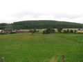
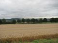
this is Dögerode and behind it the forest of the last hash
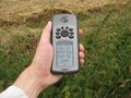
proof
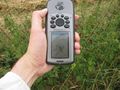
proof2
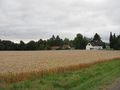
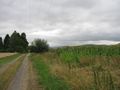
a farm near the hash
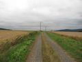
way in the fields, northward
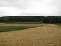
view to the west, the forest of the last hash
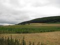
view to the southwest
view to the south
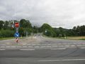
view to the east
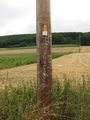
the internet was here! I should try a better handwriting
the way home


Achievements
GeorgDerReisende earned the Thumbs Up Geohash Achievement
|