Difference between revisions of "2013-08-10 33 -116"
From Geohashing
imported>LucasBrown |
imported>FippeBot m (Location) |
||
| Line 17: | Line 17: | ||
[[Category:Expeditions with photos]] | [[Category:Expeditions with photos]] | ||
[[Category:Coordinates reached]] | [[Category:Coordinates reached]] | ||
| + | {{location|US|CA|SD}} | ||
Latest revision as of 03:33, 14 August 2019
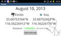
| Sat 10 Aug 2013 in 33,-116: 33.0075376, -116.5622691 geohashing.info google osm bing/os kml crox |
Location
In a grassy field nestled between the Sunrise Highway and CA SR79 at their junction in the Laguna Mountains of San Diego County, CA
Participants
Photos
Geohash Droid details page at the hashpoint
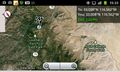
Map at hashpoint

