Difference between revisions of "2013-08-28 51 9"
From Geohashing
imported>GeorgDerReisende (new expedition to Benterode) |
imported>FippeBot m (Location) |
||
| (2 intermediate revisions by one other user not shown) | |||
| Line 1: | Line 1: | ||
| − | |||
| − | |||
| − | |||
| − | |||
| − | |||
| − | |||
| − | |||
| − | |||
| − | |||
| − | |||
{{meetup graticule | {{meetup graticule | ||
| lat=51 | | lat=51 | ||
| Line 18: | Line 8: | ||
__NOTOC__ | __NOTOC__ | ||
== Location == | == Location == | ||
| − | + | ||
| + | The hash lies at the western side of the road from Benterode to Uschlag. | ||
== Participants == | == Participants == | ||
| − | + | ||
| − | + | [[User:GeorgDerReisende|GeorgDerReisende]] | |
== Plans == | == Plans == | ||
| − | + | ||
| + | To go there, have the usual fun, then go home. | ||
== Expedition == | == Expedition == | ||
| − | + | ||
| + | I started at home at 15:00, taking the tram, then one bus, a second bus and a third bus to Benterode, then I have made some steps. After taking the photos I returned home, this time by hitchhiking. | ||
== Tracklog == | == Tracklog == | ||
| Line 34: | Line 27: | ||
== Photos == | == Photos == | ||
| − | |||
| − | |||
| − | |||
<gallery perrow="5"> | <gallery perrow="5"> | ||
| + | Image:2013-08-28 51 9 GeorgDerReisende 8902.jpg | Benterode | ||
| + | Image:2013-08-28 51 9 GeorgDerReisende 8909.jpg | not near enough | ||
| + | Image:2013-08-28 51 9 GeorgDerReisende 8910.jpg | 4 m away | ||
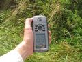
| + | Image:2013-08-28 51 9 GeorgDerReisende 8913.jpg | proof1 | ||
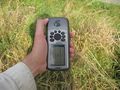
| + | Image:2013-08-28 51 9 GeorgDerReisende 8917.jpg | proof2 | ||
| + | Image:2013-08-28 51 9 GeorgDerReisende 8915.jpg | view to the east | ||
| + | Image:2013-08-28 51 9 GeorgDerReisende 8921.jpg | view to the north | ||
| + | Image:2013-08-28 51 9 GeorgDerReisende 8922.jpg | view to the west | ||
| + | Image:2013-08-28 51 9 GeorgDerReisende 8923.jpg | view to Uschlag | ||
| + | Image:2013-08-28 51 9 GeorgDerReisende 8924.jpg | view to southeast | ||
| + | Image:2013-08-28 51 9 GeorgDerReisende 8928.jpg | a better view to Benterode | ||
| + | Image:2013-08-28 51 9 GeorgDerReisende 8931.jpg | Uschlag | ||
</gallery> | </gallery> | ||
== Achievements == | == Achievements == | ||
{{#vardefine:ribbonwidth|800px}} | {{#vardefine:ribbonwidth|800px}} | ||
| − | |||
| + | {{Public transport geohash | latitude = 51 | longitude = 9 | date = 2013-08-28 | busline = buses 30, 31 & 32 | name = GeorgDerReisende }} | ||
| − | + | [[Category:Expeditions]] | |
| − | |||
| − | [[Category: | ||
| − | + | [[Category:Expeditions with photos]] | |
| − | |||
| − | [[Category: | ||
| − | |||
| − | |||
| − | |||
| − | |||
| − | |||
| − | |||
| − | |||
| − | |||
| − | |||
| − | |||
[[Category:Coordinates reached]] | [[Category:Coordinates reached]] | ||
| − | + | {{location|DE|NI|GÖ}} | |
| − | |||
| − | |||
| − | |||
| − | |||
| − | |||
| − | |||
| − | |||
| − | |||
| − | |||
| − | |||
| − | |||
| − | |||
| − | |||
| − | |||
| − | |||
| − | |||
| − | |||
Latest revision as of 03:45, 14 August 2019
| Wed 28 Aug 2013 in 51,9: 51.3385872, 9.6231009 geohashing.info google osm bing/os kml crox |
Location
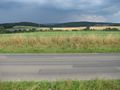
The hash lies at the western side of the road from Benterode to Uschlag.
Participants
Plans
To go there, have the usual fun, then go home.
Expedition
I started at home at 15:00, taking the tram, then one bus, a second bus and a third bus to Benterode, then I have made some steps. After taking the photos I returned home, this time by hitchhiking.
Tracklog
Photos
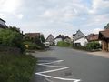
Benterode
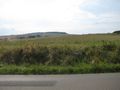
not near enough
4 m away
proof1
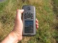
proof2
view to the east
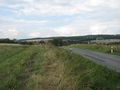
view to the north
view to the west
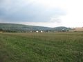
view to Uschlag
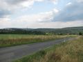
view to southeast
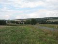
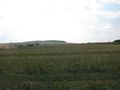
a better view to Benterode
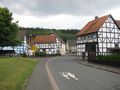
Uschlag


Achievements
GeorgDerReisende earned the Public transport geohash achievement
|