Difference between revisions of "2013-08-28 52 1"
imported>Sourcerer (→Sourcerer Failed Expedition) |
imported>Palmpje m (→Participants: markup) |
||
| Line 24: | Line 24: | ||
<!-- who attended: If you link to your wiki user name in this section, your expedition will be picked up by the various statistics generated for geohashing. You may use three tildes ~ as a shortcut to automatically insert the user signature of the account you are editing with. | <!-- who attended: If you link to your wiki user name in this section, your expedition will be picked up by the various statistics generated for geohashing. You may use three tildes ~ as a shortcut to automatically insert the user signature of the account you are editing with. | ||
--> | --> | ||
| − | [[User:MagicIan|MagicIan]] | + | * [[User:MagicIan|MagicIan]] |
| − | [[User:Sourcerer|Sourcerer]] | + | * [[User:Sourcerer|Sourcerer]] |
Neither realised the other was attempting it... | Neither realised the other was attempting it... | ||
Revision as of 11:03, 18 September 2013
| Wed 28 Aug 2013 in 52,1: 52.3385872, 1.6231009 geohashing.info google osm bing/os kml crox |
Location
In a field above Suffolk Wildlife Trust Hen Reedbeds Nature Reserve, near Wangford
Participants
Neither realised the other was attempting it...
Expedition
MagicIan had the week off work after the bank holiday before starting a new job, and was taking advantage of the summer sunshine by going for a nice long cycle (~60 miles round trip). It was a pleasant route mainly on quiet back roads. He stopped for a sandwich in the village of Wangford before continuing past the waste disposal site to Mardle Road adjacent to the field containing the hashpoint. He parked his bike at Suffolk Wildlife Trust Hen Reed beds Nature Reserve and walked from there. After working out there was no access from the nature reserve he backtracked up Mardle Road and hopped into the field through a gap in the hedge by the woods. From there it was a short walk through the woods themselves, coming out ~35m from the hashpoint. He could've walked into the field to get closer but there were crops growing that he didn't want to damage. For this reason he is claiming the expedition as a success.
- Failed to reach hashpoint. -- Sourcerer (talk) @52.3365,1.6241 22:18, 28 August 2013 (GMT+01:00)
Sourcerer attempted this after a busy day spent preparing and then demonstrating a Raspberry Pi computer being used for Amateur Radio. Several other enthusiasts were also demonstrating, mostly rather more advanced projects however I had got the games working on my Pi.
After the meeting at about 21:20 it was already dark and the drive towards Southwold took a while. Fog banks were forming and there was no moon. There was a very convenient car park for the nature reserve and a path lead to a bird watching platform and screen. The field containing the hashpoint was well fenced and obviously part of the nature reserve. In the dark and fog, it would have been possible to climb a gate with a clear No Access sign and cross the field but this might have caused damage so this was ruled out. It was late and after a tiring day. blundering about in the dark looking for a better access point seemed pointless. Of course I should have fired up my Droid and read this page using MagicIan's directions. It was rather nice at the reserve but not too quiet. There was a procession of traffic leaving Southwold, most likely after a Summer Theatre performance. After a half hearted attempt to find an alternative route, Neil joined the procession of cars and went home.
Tracklog
Photos
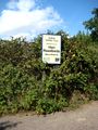
Photo taken at Suffolk Wildlife Trust Hen Reedbeds Nature Reserve near the hashpoint for Wednesday 28-08-2013, 52.338587°, 1.623100° (Norwich, United Kingdom)
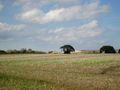
Photo taken of the waste disposal site on the way to the hashpoint for Wednesday 28-08-2013, 52.338587°, 1.623100° (Norwich, United Kingdom)
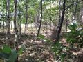
Photo taken while walking through the woods on the way to the hashpoint for Wednesday 28-08-2013, 52.338587°, 1.623100° (Norwich, United Kingdom)
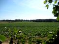
Photo of the hashpoint for Wednesday 28-08-2013, 52.338587°, 1.623100° (Norwich, United Kingdom)
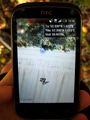
Photo of phone (as it was refusing to save a screenshot) showing proximity of the hashpoint for Wednesday 28-08-2013, 52.338587°, 1.623100° (Norwich, United Kingdom)


Achievements
MagicIan earned the Bicycle geohash achievement
|