Difference between revisions of "2013-09-06 51 9"
From Geohashing
imported>GeorgDerReisende (new expedition to Immenhausen-Holzhausen) |
imported>FippeBot m (Location) |
||
| (4 intermediate revisions by one other user not shown) | |||
| Line 1: | Line 1: | ||
| − | |||
| − | |||
| − | |||
| − | |||
| − | |||
| − | |||
| − | |||
| − | |||
| − | |||
| − | |||
{{meetup graticule | {{meetup graticule | ||
| lat=51 | | lat=51 | ||
| Line 18: | Line 8: | ||
__NOTOC__ | __NOTOC__ | ||
== Location == | == Location == | ||
| − | + | ||
| + | The hash lies on a meadow at the western side of Immenhausen-Holzhausen. | ||
== Participants == | == Participants == | ||
| − | + | ||
| − | + | [[User:GeorgDerReisende|GeorgDerReisende]] | |
== Plans == | == Plans == | ||
| − | + | ||
| + | hitchhiking | ||
== Expedition == | == Expedition == | ||
| − | + | ||
| + | Instead of hitchhiking I have taken the bus, which showed as a good idea, because there are streetworks in Holzhausen, which lead to big detours for the cars. Then I walked to the meadow and have seen, that there is a fence around it, and I wondered, if I could go near enough. After some waiting at the fence the point of my Garmin walked towards the hash and all went good. Three meters away. Then I have made a walk around the place and then I travelled home, again by public transport. | ||
== Tracklog == | == Tracklog == | ||
| Line 34: | Line 27: | ||
== Photos == | == Photos == | ||
| − | |||
| − | |||
| − | |||
<gallery perrow="5"> | <gallery perrow="5"> | ||
| + | Image:2013-09-06 51 9 GeorgDerReisende 9677.jpg | the meadow with a fence | ||
| + | Image:2013-09-06 51 9 GeorgDerReisende 9679.jpg | there is the hash (some meters) | ||
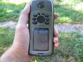
| + | Image:2013-09-06 51 9 GeorgDerReisende 9682.jpg | proof1 | ||
| + | Image:2013-09-06 51 9 GeorgDerReisende 9685.jpg | proof2 | ||
| + | Image:2013-09-06 51 9 GeorgDerReisende 9689.jpg | the trees behind the meadow | ||
| + | Image:2013-09-06 51 9 GeorgDerReisende 9690.jpg | the lake near the meadow | ||
</gallery> | </gallery> | ||
| Line 44: | Line 40: | ||
<!-- Add any achievement ribbons you earned below, or remove this section --> | <!-- Add any achievement ribbons you earned below, or remove this section --> | ||
| + | {{Public transport geohash | latitude = 51 | longitude = 9 | date = 2013-09-06 | busline = bus 40 | name = GeorgDerReisende }} | ||
| − | + | [[Category:Expeditions]] | |
| − | |||
| − | [[Category: | ||
| − | + | [[Category:Expeditions with photos]] | |
| − | |||
| − | [[Category: | ||
| − | |||
| − | |||
| − | |||
| − | |||
| − | |||
| − | |||
| − | |||
| − | |||
| − | |||
| − | |||
[[Category:Coordinates reached]] | [[Category:Coordinates reached]] | ||
| − | + | {{location|DE|HE|KS}} | |
| − | |||
| − | |||
| − | |||
| − | |||
| − | |||
| − | |||
| − | |||
| − | |||
| − | |||
| − | |||
| − | |||
| − | |||
| − | |||
| − | |||
| − | |||
| − | |||
| − | |||
Latest revision as of 03:53, 14 August 2019
| Fri 6 Sep 2013 in 51,9: 51.4282816, 9.5322994 geohashing.info google osm bing/os kml crox |
Location
The hash lies on a meadow at the western side of Immenhausen-Holzhausen.
Participants
Plans
hitchhiking
Expedition
Instead of hitchhiking I have taken the bus, which showed as a good idea, because there are streetworks in Holzhausen, which lead to big detours for the cars. Then I walked to the meadow and have seen, that there is a fence around it, and I wondered, if I could go near enough. After some waiting at the fence the point of my Garmin walked towards the hash and all went good. Three meters away. Then I have made a walk around the place and then I travelled home, again by public transport.
Tracklog
Photos
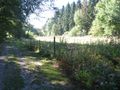
the meadow with a fence
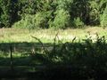
there is the hash (some meters)

proof1
proof2
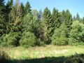
the trees behind the meadow
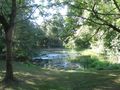
the lake near the meadow


Achievements
GeorgDerReisende earned the Public transport geohash achievement
|