Difference between revisions of "2013-09-06 -43 172"
From Geohashing
imported>Quaternary (Created page with " {{subst:Expedition |lat = -43 |lon = 172 |date = 2013-09-06 }}") |
imported>FippeBot m (Location) |
||
| (6 intermediate revisions by one other user not shown) | |||
| Line 22: | Line 22: | ||
== Participants == | == Participants == | ||
| − | + | [[User:Quaternary|Quaternary]] ([[User talk:Quaternary|talk]]) | |
| − | |||
== Plans == | == Plans == | ||
| Line 29: | Line 28: | ||
== Expedition == | == Expedition == | ||
| − | + | Sadly, while the site had looked publically accessible, the river bed was fenced off with an electric fence! | |
== Tracklog == | == Tracklog == | ||
| Line 38: | Line 37: | ||
Image:2012-##-## ## ## Alpha.jpg | Witty Comment | Image:2012-##-## ## ## Alpha.jpg | Witty Comment | ||
--> | --> | ||
| − | <gallery perrow=" | + | <gallery perrow="4"> |
| + | Image:2013_09_06_-43_172__The_Waimakiriri_River.JPG | The mighty Waimakiriri, meaning 'cold water river' | ||
| + | Image:2013_09_06_-43_172_Finishing_The_Embackments.JPG | Finishing the embackments | ||
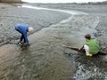
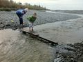
| + | Image:2013_09_06_-43_172_Placing_the_bridge_in_place.JPG | Placing the bridge | ||
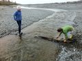
| + | Image:2013_09_06_-43_172_Testing,_but_will_it_hold_dads_weight.JPG | Testing the bridge, but will it hold dad's weight? | ||
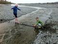
| + | Image:2013_09_06_-43_172_Bridge_for_dad_and_some_encouragement.JPG | "Come on dad, it'll hold your weight!" | ||
| + | Image:2013_09_06_-43_172_Feet_not_too_wet.JPG | Well done! My feet didn't get too wet! | ||
| + | Image:2013_09_06_-43_172_Within_350_metres.JPG | Thawted! A mere 350 metres from the hash point, to be stopped by an electric fence, and a field full of cows. | ||
</gallery> | </gallery> | ||
| Line 46: | Line 52: | ||
| − | <!-- =============== USEFUL CATEGORIES FOLLOW ================ | + | <!-- =============== USEFUL CATEGORIES FOLLOW ================ --> |
| − | |||
| − | |||
| − | |||
| − | |||
| − | |||
| − | |||
| − | |||
[[Category:Expeditions]] | [[Category:Expeditions]] | ||
| − | |||
[[Category:Expeditions with photos]] | [[Category:Expeditions with photos]] | ||
| − | |||
| − | |||
| − | |||
| − | |||
| − | |||
| − | |||
| − | |||
| − | |||
[[Category:Coordinates not reached]] | [[Category:Coordinates not reached]] | ||
| − | |||
| − | |||
| − | |||
| − | |||
| − | |||
[[Category:Not reached - No public access]] | [[Category:Not reached - No public access]] | ||
| − | + | {{location|NZ|CAN}} | |
| − | |||
| − | |||
| − | |||
| − | |||
| − | |||
| − | |||
| − | |||
Latest revision as of 03:52, 14 August 2019
| Fri 6 Sep 2013 in -43,172: -43.4282816, 172.5322994 geohashing.info google osm bing/os kml crox |
Location
Participants
Plans
Expedition
Sadly, while the site had looked publically accessible, the river bed was fenced off with an electric fence!
Tracklog
Photos
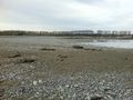
The mighty Waimakiriri, meaning 'cold water river'
Finishing the embackments
Placing the bridge
Testing the bridge, but will it hold dad's weight?
"Come on dad, it'll hold your weight!"
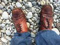
Well done! My feet didn't get too wet!
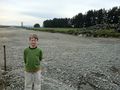
Thawted! A mere 350 metres from the hash point, to be stopped by an electric fence, and a field full of cows.


