Difference between revisions of "2013-09-08 51 10"
imported>GeorgDerReisende (new expedition to Dögerode) |
imported>FippeBot m (Location) |
||
| (One intermediate revision by one other user not shown) | |||
| Line 1: | Line 1: | ||
| − | |||
| − | |||
| − | |||
| − | |||
| − | |||
| − | |||
| − | |||
| − | |||
| − | |||
| − | |||
{{meetup graticule | {{meetup graticule | ||
| lat=51 | | lat=51 | ||
| Line 30: | Line 20: | ||
== Expedition == | == Expedition == | ||
| − | + | ||
| + | I have left home at 11:45, arrived at the hitchhiking spot at 12:40, got there a lift after ten minutes. I had to change the car at the service station Göttingen with a waiting time of five minutes and I arrived at the junction Echte at 13:55. From there I walked to the hash, where I arrived at about 14:40. I have taken some photos and then walked home with a detour around the industrial area of Dögerode. I arrived at the junction Echte at 16:35, waited there for ten minutes and got a car to the junction Kassel-Ost, where I arrived at 17:30. I arrived at home at 18:15. | ||
== Tracklog == | == Tracklog == | ||
| Line 40: | Line 31: | ||
--> | --> | ||
<gallery perrow="5"> | <gallery perrow="5"> | ||
| + | Image:2013-09-08 51 10 GeorgDerReisende 9992.jpg | satisfaction is near | ||
| + | Image:2013-09-08 51 10 GeorgDerReisende 9999.jpg | today's hash is to the left, in the middle behind the trees [[2013-07-17 51 10]], to the right at the edge of the field of maize [[2013-08-08 51 10]] | ||
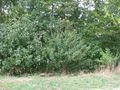
| + | Image:2013-09-08 51 10 GeorgDerReisende 10008.jpg | there is the hash | ||
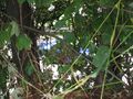
| + | Image:2013-09-08 51 10 GeorgDerReisende 10009.jpg | proof1 | ||
| + | Image:2013-09-08 51 10 GeorgDerReisende 10019.jpg | proof2 | ||
| + | Image:2013-09-08 51 10 GeorgDerReisende 10011.jpg | view to the west | ||
| + | Image:2013-09-08 51 10 GeorgDerReisende 10012.jpg | behind the bushes there is the motorway | ||
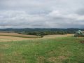
| + | Image:2013-09-08 51 10 GeorgDerReisende 10013.jpg | landscape of northeast | ||
| + | Image:2013-09-08 51 10 GeorgDerReisende 10015.jpg | landscape to the northeast | ||
| + | Image:2013-09-08 51 10 GeorgDerReisende 10016.jpg | landscape to the east | ||
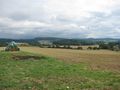
| + | Image:2013-09-08 51 10 GeorgDerReisende 10017.jpg | landscape view to Oldershausen | ||
| + | Image:2013-09-08 51 10 GeorgDerReisende 10018.jpg | landscape to the south | ||
</gallery> | </gallery> | ||
| Line 46: | Line 49: | ||
<!-- Add any achievement ribbons you earned below, or remove this section --> | <!-- Add any achievement ribbons you earned below, or remove this section --> | ||
| + | {{Thumbs Up | latitude = 51 | longitude = 10 | date = 2013-09-08 | name = GeorgDerReisende }} | ||
| − | + | [[Category:Expeditions]] | |
| − | |||
| − | [[Category: | ||
| − | + | [[Category:Expeditions with photos]] | |
| − | |||
| − | [[Category: | ||
| − | |||
| − | |||
| − | |||
| − | |||
| − | |||
| − | |||
| − | |||
| − | |||
| − | |||
| − | |||
[[Category:Coordinates reached]] | [[Category:Coordinates reached]] | ||
| − | + | {{location|DE|NI|NOM}} | |
| − | |||
| − | |||
| − | |||
| − | |||
| − | |||
| − | |||
| − | |||
| − | |||
| − | |||
| − | |||
| − | |||
| − | |||
| − | |||
| − | |||
| − | |||
| − | |||
| − | |||
Latest revision as of 03:55, 14 August 2019
| Sun 8 Sep 2013 in 51,10: 51.8004840, 10.0880283 geohashing.info google osm bing/os kml crox |
Location
The hash lies on an edge of a field north of Oldershausen.
Participants
Plans
This is my third expedition to this area around Dögerode. I have to hitchhike to Echte and then I will walk around.
Expedition
I have left home at 11:45, arrived at the hitchhiking spot at 12:40, got there a lift after ten minutes. I had to change the car at the service station Göttingen with a waiting time of five minutes and I arrived at the junction Echte at 13:55. From there I walked to the hash, where I arrived at about 14:40. I have taken some photos and then walked home with a detour around the industrial area of Dögerode. I arrived at the junction Echte at 16:35, waited there for ten minutes and got a car to the junction Kassel-Ost, where I arrived at 17:30. I arrived at home at 18:15.
Tracklog
Photos
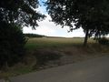
satisfaction is near
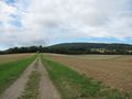
today's hash is to the left, in the middle behind the trees 2013-07-17 51 10, to the right at the edge of the field of maize 2013-08-08 51 10
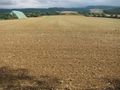
there is the hash
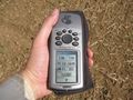
proof1

proof2
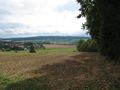
view to the west
behind the bushes there is the motorway

landscape of northeast
landscape to the northeast
landscape to the east
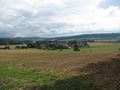
landscape view to Oldershausen
landscape to the south


Achievements
GeorgDerReisende earned the Thumbs Up Geohash Achievement
|