Difference between revisions of "2013-09-08 43 -116"
imported>Eldin ([live] Hash reached!) |
imported>FippeBot m (Location) |
||
| (2 intermediate revisions by one other user not shown) | |||
| Line 1: | Line 1: | ||
| − | |||
| − | |||
| − | |||
| − | |||
| − | |||
| − | |||
| − | |||
| − | |||
| − | |||
| − | |||
{{meetup graticule | {{meetup graticule | ||
| lat=43 | | lat=43 | ||
| Line 15: | Line 5: | ||
}} | }} | ||
| − | |||
__NOTOC__ | __NOTOC__ | ||
== Location == | == Location == | ||
| − | + | On a forest service road north of the Bogus Basin ski area. | |
== Participants == | == Participants == | ||
| − | + | * [[User:Eldin|Eldin]] | |
| − | |||
| − | |||
| − | |||
| − | |||
== Expedition == | == Expedition == | ||
| − | + | I had some time this afternoon, and the hash looked very reachable. So I decided to try to reach it. From the satelite imagery, it looked like the hash was right on a logging road. Due to winding, poor quality roads, it took over an hour to drive to the vicinity of the hash. I found a spot where I could turn my car around and park it about 750ft from the hash, and parked. At this point I realized that I'd left my camera at home. So I set my phone to record a tracklog for the walking portion of my expedition. As I walked down the road towards the hash, I realized that the hash was actually a bit south of the road, up a rather steep slope. So I got to about 20ft from the hash and started climbing. It wasn't a very easy climb, the slope being composed largely of very coarse sand/fine gravel. But after a bit of zig-zagging, I got within the 4ft margin of error on my phone's GPS. The hash appeared to be very nearly in the same spot that a small pine tree was growing. I sat down by the tree and took some pictures, posted a message here indicating my success, and then walked/slid back down to the road and took some more pictures, and headed back to my car. | |
| + | *Hash reached! -- [[User:Eldin|Eldin]] ([[User talk:Eldin|talk]]) [http://www.openstreetmap.org/?lat=43.80049425&lon=-116.08803917&zoom=16&layers=B000FTF @43.8005,-116.0880] 16:56, 8 September 2013 (MDT) | ||
| − | |||
== Tracklog == | == Tracklog == | ||
| − | + | [[http://goo.gl/maps/FkIRt]] - This shows the relatively short walking portion of my expedition. The blue marker is the hashpoint. | |
| − | |||
== Photos == | == Photos == | ||
| − | |||
| − | |||
| − | |||
<gallery perrow="5"> | <gallery perrow="5"> | ||
| + | File:2013-09-08 43 -116 grin.jpg | A grinning geohasher. | ||
| + | File:2013-09-08 43 -116 point.jpg | This tree is growing very nearly on the hash point. | ||
| + | File:2013-09-08 43 -116 road.jpg | Looking down at the road from the hash point. | ||
| + | File:2013-09-08 43 -116 rocks.jpg | Rock formation above the hash point. | ||
| + | File:2013-09-08 43 -116 view1.jpg | The view to the north. | ||
| + | File:2013-09-08 43 -116 view2.jpg | And the view to the west. | ||
</gallery> | </gallery> | ||
== Achievements == | == Achievements == | ||
{{#vardefine:ribbonwidth|800px}} | {{#vardefine:ribbonwidth|800px}} | ||
| − | + | {{Land geohash|date=2013-09-08|latitude=43|longitude=-116|name=[[User:Eldin|Eldin]]}} | |
| + | {{consecutive geohash 2 | count = 2 | latitude = 43 | longitude = -116 | date = 2013-09-07 | name = [[User:Eldin|Eldin]]}} | ||
| − | |||
| − | |||
| − | |||
| − | |||
| − | |||
| − | |||
| − | |||
| − | |||
| − | |||
| − | |||
| − | |||
[[Category:Expeditions]] | [[Category:Expeditions]] | ||
| − | |||
[[Category:Expeditions with photos]] | [[Category:Expeditions with photos]] | ||
| − | |||
| − | |||
| − | |||
| − | |||
| − | |||
[[Category:Coordinates reached]] | [[Category:Coordinates reached]] | ||
| − | + | {{location|US|ID|BS}} | |
| − | |||
| − | |||
| − | |||
| − | |||
| − | |||
| − | |||
| − | |||
| − | |||
| − | |||
| − | |||
| − | |||
| − | |||
| − | |||
| − | |||
| − | |||
| − | |||
| − | |||
Latest revision as of 06:31, 6 August 2019
| Sun 8 Sep 2013 in 43,-116: 43.8004840, -116.0880283 geohashing.info google osm bing/os kml crox |
Location
On a forest service road north of the Bogus Basin ski area.
Participants
Expedition
I had some time this afternoon, and the hash looked very reachable. So I decided to try to reach it. From the satelite imagery, it looked like the hash was right on a logging road. Due to winding, poor quality roads, it took over an hour to drive to the vicinity of the hash. I found a spot where I could turn my car around and park it about 750ft from the hash, and parked. At this point I realized that I'd left my camera at home. So I set my phone to record a tracklog for the walking portion of my expedition. As I walked down the road towards the hash, I realized that the hash was actually a bit south of the road, up a rather steep slope. So I got to about 20ft from the hash and started climbing. It wasn't a very easy climb, the slope being composed largely of very coarse sand/fine gravel. But after a bit of zig-zagging, I got within the 4ft margin of error on my phone's GPS. The hash appeared to be very nearly in the same spot that a small pine tree was growing. I sat down by the tree and took some pictures, posted a message here indicating my success, and then walked/slid back down to the road and took some more pictures, and headed back to my car.
- Hash reached! -- Eldin (talk) @43.8005,-116.0880 16:56, 8 September 2013 (MDT)
Tracklog
[[1]] - This shows the relatively short walking portion of my expedition. The blue marker is the hashpoint.
Photos

A grinning geohasher.
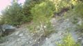
This tree is growing very nearly on the hash point.
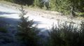
Looking down at the road from the hash point.
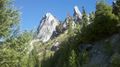
Rock formation above the hash point.
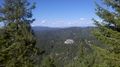
The view to the north.
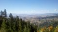
And the view to the west.


Achievements
Eldin earned the Land geohash achievement
|
Eldin earned the Consecutive geohash achievement
|