Difference between revisions of "2013-09-15 47 -122"
From Geohashing
imported>Zebburkeconte |
imported>FippeBot m (Location) |
||
| (4 intermediate revisions by 2 users not shown) | |||
| Line 15: | Line 15: | ||
}} | }} | ||
| − | + | ||
__NOTOC__ | __NOTOC__ | ||
== Location == | == Location == | ||
| Line 21: | Line 21: | ||
== Participants == | == Participants == | ||
| − | [[User:Zebburkeconte|Zebburkeconte]] and [[User:Zebburkeconte|Zebburkeconte]] 's mom | + | * [[User:Zebburkeconte|Zebburkeconte]] and |
| + | * [[User:Zebburkeconte|Zebburkeconte]]'s mom | ||
== Plans == | == Plans == | ||
| − | + | Should be an easy geohash, right off the road. | |
== Expedition == | == Expedition == | ||
| − | + | It went off without a hitch. We arrived, and found it was in the front yard it had been surveyed to be in. GPS on iPhone was having some issues, closest it showed was 13.5 feet although I know I stood on the point itself as I walked on the area it was in on the satellite image. | |
| − | == | + | == Photos == |
| − | |||
| − | |||
| − | |||
| − | |||
| − | |||
<gallery perrow="5"> | <gallery perrow="5"> | ||
| + | Image:2013.09.15.47.-122.1.png | Photo with Geohash+ | ||
| + | Image:2013.09.15.47.-122.2.png | Photo with Geohasher (and apparently zoosk ad) | ||
| + | Image:2013.09.15.47.-122.3.jpg | My first Stupid Grin! | ||
</gallery> | </gallery> | ||
== Achievements == | == Achievements == | ||
{{#vardefine:ribbonwidth|800px}} | {{#vardefine:ribbonwidth|800px}} | ||
| − | + | {{land geohash | |
| + | | latitude = 47 | ||
| + | | longitude = -122 | ||
| + | | date = 2013-09-15 | ||
| + | | name = Zebburkeconte | ||
| + | }} | ||
| − | |||
| − | |||
| − | |||
| − | + | [[Category:Expeditions]] | |
| − | |||
| − | [[Category: | ||
| − | |||
| − | |||
| − | |||
| − | |||
[[Category:Expeditions with photos]] | [[Category:Expeditions with photos]] | ||
| − | |||
| − | |||
| − | |||
| − | |||
| − | |||
[[Category:Coordinates reached]] | [[Category:Coordinates reached]] | ||
| − | + | {{location|US|WA|KN}} | |
| − | |||
| − | |||
| − | |||
| − | |||
| − | |||
| − | |||
| − | |||
| − | |||
| − | |||
| − | |||
| − | |||
| − | |||
| − | |||
| − | |||
| − | |||
| − | |||
| − | |||
Latest revision as of 04:00, 14 August 2019
| Sun 15 Sep 2013 in 47,-122: 47.6707949, -122.1776052 geohashing.info google osm bing/os kml crox |
Location
Someone's front lawn in Kirkland.
Participants
- Zebburkeconte and
- Zebburkeconte's mom
Plans
Should be an easy geohash, right off the road.
Expedition
It went off without a hitch. We arrived, and found it was in the front yard it had been surveyed to be in. GPS on iPhone was having some issues, closest it showed was 13.5 feet although I know I stood on the point itself as I walked on the area it was in on the satellite image.
Photos
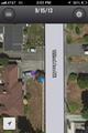
Photo with Geohash+
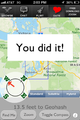
Photo with Geohasher (and apparently zoosk ad)

My first Stupid Grin!


Achievements
Zebburkeconte earned the Land geohash achievement
|