Difference between revisions of "2013-10-17 32 -116"
From Geohashing
imported>LucasBrown (Geohash Droid details page at the hashpoint) |
imported>FippeBot m (Location) |
||
| (4 intermediate revisions by one other user not shown) | |||
| Line 1: | Line 1: | ||
| + | {{meetup graticule | lat=32 | lon=-116 | date=2013-10-17}} | ||
| − | |||
| − | |||
| − | |||
| − | |||
| − | |||
| − | |||
| − | |||
| − | |||
| − | |||
| − | |||
| − | |||
| − | |||
| − | |||
| − | |||
| − | |||
| − | |||
__NOTOC__ | __NOTOC__ | ||
== Location == | == Location == | ||
| − | + | About 50m west of Barona Road and 3km northeast of Barona Resort and Casino on the Barona Indian Reservation in San Diego County, CA | |
== Participants == | == Participants == | ||
| − | + | [[User:LucasBrown|LucasBrown]] | |
| − | |||
== Plans == | == Plans == | ||
| Line 30: | Line 14: | ||
<!-- how it all turned out. your narrative goes here. --> | <!-- how it all turned out. your narrative goes here. --> | ||
| + | [[User:LucasBrown|LucasBrown]] reached the hashpoint at 17:36 PDT by following a route qualifying for the [[Tron achievement]]. He would like to note that the apparent path-crossing in his tracklog (which can be found at the start/end of the route just south of Twin Peaks Road in Poway and in the vicinity of the hashpoint) is due to GPS inaccuracies and not actual path-crossing. | ||
* -- | * -- | ||
== Tracklog == | == Tracklog == | ||
| − | + | [[User:LucasBrown|LucasBrown]]'s tracklog: https://docs.google.com/file/d/0B31DVyBvktcrY0pVLVBrVlJVWUk | |
== Photos == | == Photos == | ||
| − | |||
| − | |||
| − | |||
<gallery perrow="5"> | <gallery perrow="5"> | ||
| − | + | Image:2013-10-17_32_-116_18-24-28-236.jpg | ([[User:LucasBrown|LucasBrown]]) Geohash Droid details page at the hashpoint | |
| − | Image:2013-10-17_32_-116_18-24-28-236.jpg | Geohash Droid details page at the hashpoint | ||
</gallery> | </gallery> | ||
== Achievements == | == Achievements == | ||
{{#vardefine:ribbonwidth|800px}} | {{#vardefine:ribbonwidth|800px}} | ||
| − | + | {{Tron | latitude = 32 | longitude = -116 | date = 2013-10-17 | name = LucasBrown | tracklog = https://docs.google.com/file/d/0B31DVyBvktcrY0pVLVBrVlJVWUk | possessive = his}} | |
| − | |||
| − | |||
| − | |||
| − | |||
| − | |||
| − | |||
| − | |||
| − | |||
| − | |||
| − | |||
[[Category:Expeditions]] | [[Category:Expeditions]] | ||
| − | |||
[[Category:Expeditions with photos]] | [[Category:Expeditions with photos]] | ||
| − | [[Category:Expeditions with videos]] | + | <!-- [[Category:Expeditions with videos]] --> |
| − | |||
| − | --> | ||
| − | |||
| − | |||
[[Category:Coordinates reached]] | [[Category:Coordinates reached]] | ||
| − | + | <!-- or if you failed :( | |
| − | |||
[[Category:Coordinates not reached]] | [[Category:Coordinates not reached]] | ||
-- and a reason -- | -- and a reason -- | ||
| Line 87: | Line 52: | ||
(Don't forget to delete this final close comment marker) --> | (Don't forget to delete this final close comment marker) --> | ||
| + | {{location|US|CA|SD}} | ||
Latest revision as of 04:21, 14 August 2019
| Thu 17 Oct 2013 in 32,-116: 32.9599825, -116.8369884 geohashing.info google osm bing/os kml crox |
Location
About 50m west of Barona Road and 3km northeast of Barona Resort and Casino on the Barona Indian Reservation in San Diego County, CA
Participants
Plans
Expedition
LucasBrown reached the hashpoint at 17:36 PDT by following a route qualifying for the Tron achievement. He would like to note that the apparent path-crossing in his tracklog (which can be found at the start/end of the route just south of Twin Peaks Road in Poway and in the vicinity of the hashpoint) is due to GPS inaccuracies and not actual path-crossing.
- --
Tracklog
LucasBrown's tracklog: https://docs.google.com/file/d/0B31DVyBvktcrY0pVLVBrVlJVWUk
Photos
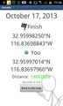
(LucasBrown) Geohash Droid details page at the hashpoint

Achievements
LucasBrown earned the Tron achievement
|