Difference between revisions of "2013-11-10 59 17"
From Geohashing
imported>DLichti |
imported>DLichti |
||
| Line 43: | Line 43: | ||
<!-- Add any achievement ribbons you earned below, or remove this section --> | <!-- Add any achievement ribbons you earned below, or remove this section --> | ||
| − | |||
| − | |||
[[Category:Expeditions]] | [[Category:Expeditions]] | ||
[[Category:Coordinates reached]] | [[Category:Coordinates reached]] | ||
[[Category:Expeditions with photos]] | [[Category:Expeditions with photos]] | ||
| + | |||
| + | <!-- =============== USEFUL CATEGORIES FOLLOW ================ | ||
Delete the next line ONLY if you have chosen the appropriate categories below. If you are unsure, don't worry. People will read your report and help you with the classification. --> | Delete the next line ONLY if you have chosen the appropriate categories below. If you are unsure, don't worry. People will read your report and help you with the classification. --> | ||
[[Category:New report]] | [[Category:New report]] | ||
Revision as of 21:12, 10 November 2013
| Sun 10 Nov 2013 in 59,17: 59.0623886, 17.8278696 geohashing.info google osm bing/os kml crox |
Location
In the woods close to Åvik in Nynäshamns kommun.
Participants
Plans
Expedition
After a half hour bus ride, I walked the remaining 2km to the hash point. Most of it was on a unpaved road, so, apart from some muddy parts, it went rather well. The last 100m were through the forest untill I found the hash point on a clearance at around 14:30. I wrote "xkcd" on the ground using some dead branches, took some pictures and went back to the bus stop to get the next bus before it got dark.
Tracklog
Photos
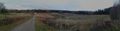
View of the road leading to that expedition's destination.
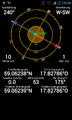
It must be here...
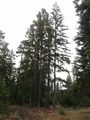
The hash point is somewhere on this clearance.
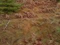
In case other hashers would visit the location, I left a message for them.


Achievements