Difference between revisions of "2013-11-26 43 -116"
imported>Eldin (Created page with "{{subst:User:Eldin/template/Expedition |lat = 43 |lon = -116 |date = 2013-11-26 |participants = * User:Eldin |location = In the desert north of the grandview highway. |ex...") |
imported>FippeBot m (Location) |
||
| (3 intermediate revisions by one other user not shown) | |||
| Line 1: | Line 1: | ||
| − | |||
| − | |||
| − | |||
| − | |||
| − | |||
| − | |||
| − | |||
| − | |||
| − | |||
| − | |||
{{meetup graticule | {{meetup graticule | ||
| lat=43 | | lat=43 | ||
| Line 15: | Line 5: | ||
}} | }} | ||
| − | |||
__NOTOC__ | __NOTOC__ | ||
| Line 25: | Line 14: | ||
== Plans == | == Plans == | ||
| − | + | Extreme lack of sleep made it seem like a good idea to drive ~70 miles round trip, largely on dirt roads, to get the 2nd to last county for the reverse regional achievement on my home graticule. | |
== Expedition == | == Expedition == | ||
| − | + | When I noticed that today's hash was in the small bit of Elmore county which sticks into my home graticule, I knew I wanted to try for it. But being on a weekday I didn't think I'd manage to get off early enough to reach the vicinity of the hash before dark. But then I ended up finihing at work by about 3pm, so I headed out to the hash. Reaching the hash wasn't too dificult. I was able to find dirt roads of varying quality to get to within a thousand feet or so of the hash. I nearly qualified for a tron hash by taking a different route home than there, but I didn't record a tracklog, and did spoil it anyway with a single U-turn after missing a turn I needed to take. It was overall an enjoyable and successful hash. | |
| − | |||
== Photos == | == Photos == | ||
| − | |||
| − | |||
| − | |||
<gallery perrow="5"> | <gallery perrow="5"> | ||
| + | File:2013-11-26 43 -116 proof.jpg | Proof. | ||
| + | File:2013-11-26 43 -116 view.jpg | View looking west from the hash. | ||
| + | File:2013-11-26 43 -116 grin.jpg | Grinning geohasher. | ||
</gallery> | </gallery> | ||
== Achievements == | == Achievements == | ||
{{#vardefine:ribbonwidth|800px}} | {{#vardefine:ribbonwidth|800px}} | ||
| − | + | {{Land geohash|name=[[User:Eldin|Eldin]]|latitude=43|longitude=-116|date=2013-11-26}} | |
| − | |||
| − | |||
| − | |||
| − | |||
| − | |||
| − | |||
| − | |||
| − | |||
| − | |||
| − | |||
[[Category:Expeditions]] | [[Category:Expeditions]] | ||
| − | |||
[[Category:Expeditions with photos]] | [[Category:Expeditions with photos]] | ||
| − | |||
| − | |||
| − | |||
| − | |||
| − | |||
[[Category:Coordinates reached]] | [[Category:Coordinates reached]] | ||
| − | + | {{location|US|ID|EL}} | |
| − | |||
| − | |||
| − | |||
| − | |||
| − | |||
| − | |||
| − | |||
| − | |||
| − | |||
| − | |||
| − | |||
| − | |||
| − | |||
| − | |||
| − | |||
| − | |||
| − | |||
Latest revision as of 04:45, 14 August 2019
| Tue 26 Nov 2013 in 43,-116: 43.1027382, -116.1739717 geohashing.info google osm bing/os kml crox |
Location
In the desert north of the grandview highway.
Participants
Plans
Extreme lack of sleep made it seem like a good idea to drive ~70 miles round trip, largely on dirt roads, to get the 2nd to last county for the reverse regional achievement on my home graticule.
Expedition
When I noticed that today's hash was in the small bit of Elmore county which sticks into my home graticule, I knew I wanted to try for it. But being on a weekday I didn't think I'd manage to get off early enough to reach the vicinity of the hash before dark. But then I ended up finihing at work by about 3pm, so I headed out to the hash. Reaching the hash wasn't too dificult. I was able to find dirt roads of varying quality to get to within a thousand feet or so of the hash. I nearly qualified for a tron hash by taking a different route home than there, but I didn't record a tracklog, and did spoil it anyway with a single U-turn after missing a turn I needed to take. It was overall an enjoyable and successful hash.
Photos

Proof.
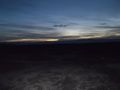
View looking west from the hash.

Grinning geohasher.


Achievements
Eldin earned the Land geohash achievement
|